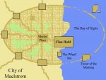
Cartography Workshop

XCorvis

First Post
Jürgen Hubert said:
Here's an alternate way of creating mountains. It's probably a good idea if you use a nice, strong primary color as a background for this...
...
This probably doesn't look as good for color layers, but it seems to be somewhat crisper for b&w maps. I'll investigate b&w effects further when I find the time, but like I said, I can use any suggestions...

Er, that's actually somewhat nauseating. Ease up on the blur.
 

log in or register to remove this ad

Jürgen Hubert

First Post
Hmmm... How about this as additional steps?


Merge everything and copy twice. Merge the two copies.
Filters->Enhance->Sharpen: 99
Select Regions by Color->Antialiasing, Select transparent areas, Threshold 100
Select->Shrink: 2
Select->Invert
Edit->Cut

I know it's still not ideal, but do you think this works better?
 

Attachments

  • MountainsColor3.png
    MountainsColor3.png
    70.4 KB · Views: 474
Last edited:

XCorvis

First Post
Jürgen Hubert said:
Hmmm... How about this as additional steps?
...
I know it's still not ideal, but do you think this works better?

I'm not fond of the specific graphic you're using, but the basic effect (to keep the shadow fuzzy but the actual object sharp) is the right way to go, IMO. So yes, that's better. :D
 

Ebonyr

First Post
When you build large cities do you draw or detail every building or do you draw them like google maps does?

I thinking about going with a layout without detailing every building and then only detail large public or special buildings or structures.

Your thoughts please.
 

Jürgen Hubert

First Post
Ebonyr said:
When you build large cities do you draw or detail every building or do you draw them like google maps does?

I thinking about going with a layout without detailing every building and then only detail large public or special buildings or structures.

Your thoughts please.

Unfortunately, I haven't drawn a city map yet, though I plan to do so within the next few months.

At the moment, my intention is to make it pretty basic - a rough layout of the neighborhoods, with the locations of the major throughfares and significant points of interest. Drawing every single building would be far too detailed - the city has more than 1,6 million inhabitants!

But at this point, I would appreciate any advice from people who have done it before.
 

terrainmonkey

First Post
hey

I've been following this thread for a while now. about cities, they are very labor and time intensive. the only real reason to do a city for a game is if it is going to be a campaign setting in itself. like the city of Bryest that i designed. it was a setting for a multi level dungeon slavers type campaign, with rival thieves guilds, assassins, and a dark overlord that held the people in an iron grip. the dungeons below the city actually were like a prison, where he would send prisoners into with barely a hope of survival to fight against the denizens of long dead necromancers in the town's history. but that is for another thread. didn't mean to bore you.

Take a look at the city of Bryest, this one took about 12 hours with Corel Draw. now that i know how to actually use the software better, something like this would only take me 2.

http://www.enworld.org/showthread.php?t=163663


Here are some maps to my campaign world that folks might like.
The first is the eastern half of the continent

http://i46.photobucket.com/albums/f127/terrainmonkey/drakold4.jpg

This is the western half
http://i46.photobucket.com/albums/f127/terrainmonkey/drakold2a.jpg

and this is the entire setting. http://i46.photobucket.com/albums/f127/terrainmonkey/drakkengardall.jpg

this process involved a hand drawn black and white map which was then scanned in and added to with text and color for the terrain features. i tried several different ways to get the maps to come out right, but finally had to break down and draw them by hand and then scan them, because i don't have a stylus just yet. that is one of the next things i get, as it will greatly speed up my map making skills. i'm still a noob compared to several people on these threads.
 

Ebonyr

First Post
Most of the cities in my homebrew will be between 10,000 to 40,000 inhabitants. I like the Ptolus city map with every building, but that is really labor intensive.

I think I going the route of the broad overview showing the major streets and points of interest. I will also do some color coding to show the different districts of each city or town.
 

Jürgen Hubert

First Post
Ebonyr said:
I think I going the route of the broad overview showing the major streets and points of interest. I will also do some color coding to show the different districts of each city or town.

I'd really like to see some filtering effects that hint at street patterns and buildings without going into detail...
 

full_moon_draw

First Post
I done this rough city map some time ago - ok it's very primitive compared to some of the stuff you guys come up with - but the streets were created by a couple of rough street plans used over & over as a "fills" in photo paint 5.

If all you're interested in is a rough layout of the city so that you can "hoof it" when your players reach the city & add detail as you go along - may be this sort of thing will do the trick?

Cheers - FMD
 

Attachments

  • Rough_Maelstrom.jpg
    Rough_Maelstrom.jpg
    27.5 KB · Views: 582

Ebonyr

First Post
Here is a ci that I have done by drawing all the buildings. It is time consuming to say the least. This map took me about 4 hours to complete. Yet, I still need to put the street names and develop a city guide showing the major interest points for further adventures.
 

Remove ads

AD6_gamerati_skyscraper

Remove ads

Recent & Upcoming Releases

Top