Knightfall's "CC2 Cartography" Thread (Retired: Apr 16/05)

Knightfall

World of Kulan DM
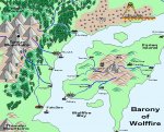
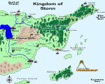
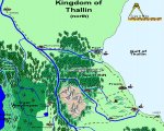
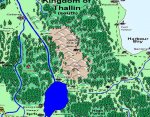
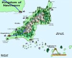
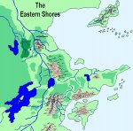
Ok, I figured I'd post some of the CC2 maps I've created here and get everyones' opinions. The map below is an overview of a region called the Eastern Shores in my World of Kulan campaign setting. (Yes, its supposed to look plain.)

{EDIT}

This is an really old version, check page three for the latest version. (You know, everytime I think I've finished fixing this map, something else comes up.)
 

Attachments

  • eastern shores.jpg
    eastern shores.jpg
    86.1 KB · Views: 716
Last edited:

log in or register to remove this ad

Knightfall

World of Kulan DM
Note: You'll see a lot of 'post deleted' posts. These are the posts of older versions of my maps that have been removed becuase they simply are to out of date to keep up here. Also, I have a tendancy to merge threads where I wrote text and forgot to attach the image.

Simply ignore them at your leisure.

Cheers!

Knightfall1972
April 29th, 2003
 
Last edited:


Knightfall

World of Kulan DM
Barony of Wolffire/Farion Island Region (Old Version)

The Barony of Wolffire. This map has been updated and reposted on page three.
 

Attachments

  • wolffire.jpg
    wolffire.jpg
    144.7 KB · Views: 709
Last edited:

Knightfall

World of Kulan DM
Kingdom of Stonn/Jagged Peninsula (Old Version)

Ok, next up is the Kingdom of Stonn. The oldest existing human kingdom on the continent except for the Empire of Swords.

{EDIT}

This map has been completely redone as to show the entire Jagged Peninsula. It is on page 3.
 

Attachments

  • stonn.jpg
    stonn.jpg
    168.9 KB · Views: 706
Last edited:

Knightfall

World of Kulan DM
Wind River Region (North)/Thallin (Old Version)

Kingdom of Thallin. A new verison of this map has been posted on page 3.
 

Attachments

  • n-thallin.jpg
    n-thallin.jpg
    219.8 KB · Views: 634
Last edited:

Knightfall

World of Kulan DM
Wind River Region (South)/Thallin (Old Version)

Thallin South. This verion is pretty bad. I was cropping maps lefdt right and center at one point in order to get them small enough to post here. I've fixed that problem for the most part.

A new, full sized version of this map is now on page 3.
 

Attachments

  • s-thallin.jpg
    s-thallin.jpg
    232.2 KB · Views: 628
Last edited:

Knightfall

World of Kulan DM
Calla Island/Navirosov (Old Version)

The Kingdom of Navirosov. This island kingdom was once part of the Eastern Council (the official alliance amongst the Kingdoms of the Eastern Shores). The kingdom is still a loose ally with the Eastern Shores but doesn't official have a treaty with them. It is a kingdom of paladins.

This map have seen much change over the last few months. The island has been completely redone although you'd have to mark every angle to notice it. The new version has been posted on page 3.
 

Attachments

  • navirosov.jpg
    navirosov.jpg
    137.7 KB · Views: 599
Last edited:


Remove ads

AD6_gamerati_skyscraper

Remove ads

Upcoming Releases

Top