EN World City Project: Geography

TGD@work

First Post
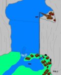
After the first contact with the dwarves, it became obvious that commerce should also continue on the river flowing to the south. The Crane (Fig 3.) was created by hired dwarves and wizards to move boats over the dam. Commerce found new ways to bring resources to the City of Coins.
-------------------------------

Comments/corrections please!
The graphics obviously need someone able to do them.
 

Attachments

  • unseendam002.jpg
    unseendam002.jpg
    33.6 KB · Views: 223
Last edited:

log in or register to remove this ad


David Argall

First Post
too magical

This origin is a good bit too specific. Unless you had real stud mages around, it just won't do.

Better to be a tad more mundane. Indeed, almost entirely so is quite reasonable.
 

Krug

Newshound
Re: too magical

David Argall said:
This origin is a good bit too specific. Unless you had real stud mages around, it just won't do.

Better to be a tad more mundane. Indeed, almost entirely so is quite reasonable.

Yeah I'd prefer a much more non-magical origin... and also not to use Col Pladoh's name. ;) I think it'll get us into the same trap as ENtropy, Eric's Grandma etc. Some folks might find us hard to take seriously if there's too many in jokes.

But nice maps! Have we settled on a dam? Did medieval folks really know how to built a dam?
 

Conaill

First Post
Medieval folks knew how to build small earthen dams. Small, because an earthen dam requires moving a LOT of dirt. You really need something like concrete (or Mud to Rock ;)) for anything fancier than that.

I'd vote against the dam idea. For one, we would have to redo most of the work we've already done on the map.

Also, I would prefer an not-so-mountainous environment. rivers flowing through mountain passes do not make for good trade routes. At most you could float logs down that sort of river. It's fine if we have some mountains around, but the flow of the river eastwards should be failry smooth.
 
Last edited:

TGD@work

First Post
The previous history was built on what I thought you had agreed on before:

---------------------------------------------------------------
Geography: (Next edit needed... Grey Dwarf, whenever you've got it finalized let me know.) The city started out on the side of some tall mountain within a mountain pass that had a river flowing through it and a dam was built across the river to cut off the water that flowed south down to a lower kingdom. As years rolled by the lake grew, and the old river bed dried up (instant clay deposits).
Eventually the water found new exits from the mountains and now there are at least two rivers exiting the lake, one of which is still trying to cut a new channel, thus creating your swamp to the west (?). Now as the lake grew the city found that it had to move higher up the mountain, and was running out of room. So someone sheared the top of one peak, leaving a vast flat region, upon which the city grew. Now of course the water level of the lake is almost even with the ground, or maybe even slightly higher.
The "islands" in the lake are really the old mountain tops of some of the smaller peaks within the mountain range.
---------------------------------------------------------------


In fact, there's no need for all this. It had a nice dramatic touch that made me want to expand it. :rolleyes:
And the dam is not supposed to be near the city.

Ok, back to the drawing board. ;)
There might be a gap between this message and the next: another funeral (very sad week endeed).
 

Knightfall

World of Kulan DM
TGD@work said:
The previous history was built on what I thought you had agreed on before:

Geography: (Next edit needed... Grey Dwarf, whenever you've got it finalized let me know.) The city started out on the side of some tall mountain within a mountain pass that had a river flowing through it and a dam was built across the river to cut off the water that flowed south down to a lower kingdom. As years rolled by the lake grew, and the old river bed dried up (instant clay deposits).
Eventually the water found new exits from the mountains and now there are at least two rivers exiting the lake, one of which is still trying to cut a new channel, thus creating your swamp to the west (?). Now as the lake grew the city found that it had to move higher up the mountain, and was running out of room. So someone sheared the top of one peak, leaving a vast flat region, upon which the city grew. Now of course the water level of the lake is almost even with the ground, or maybe even slightly higher.
The "islands" in the lake are really the old mountain tops of some of the smaller peaks within the mountain range.

Actually, this is why I asked for a re-write of the geography section. The map Grey Dwarf came up with and the written text didn't match, in my mind.

Obviously, I didn't describe my concerns well enough. Sorry for any confusion this may caused for you TGD.

Cheers!

KF72
 

The Grey Dwarf

First Post
NP, KnightFall, I'll write something else. Anyway, it was more history than geography.

It might be a good idea to remove the text from the summary before people get used to it and take it for granted (people like me ;) ).

I'll be back! :D
 

The Grey Dwarf

First Post
Conaill said:
By the way, here are some excellent links to medieval city maps, for your entertainment and inspiration...
Historic Cities: Maps & Documents: dozens of city maps, from Aachen to Zurich, and from the 15th century to the 18th.
Dutch City maps from Blaeu's Toonneel der Steden: excellent quality, aerial-view city maps from the 1600's. Lots of water, lots of military reinforcements.

There are even maps of the city where I live (ie Namur).
Great! You can even see the citadel where the river parts (NE corner)
 

Attachments

  • namur002.jpg
    namur002.jpg
    95.6 KB · Views: 211

Conaill

First Post
Hey, another Belgian! Hadn't even noticed before. :)

You cheat, you based the Mor's End map on Namur, didn't ya? :D Rotated 180 degrees, but you can't deny the resemblance...

Here's another somewhat relevant map...

Paris, 1572: Note the central island which makes for a perfect spot to cross the river. You can still clearly see the original trade route (probably a Roman road, actually) cutting straight through the city left to right. By this point the city has expanded well beyond its medieval city wall and they've dug a protective canal around the new city boundaries. Note the difference in size between both sides of the city: The Seine is friggin wide, and there isn't really any other way to cross the river than through the island.

braun_hogenberg_I_7_m.jpg
 

Remove ads

Top