Photoshop Cartography Society...

cybernetic

Explorer
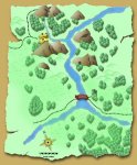
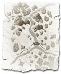
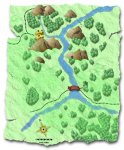
I was starting to create some brushes and actions in photoshop for making some maps and such for an upcoming campaign I plan on running soon and got to thinking that maybe my photoshop stuff I was working on might be able to aid others in creating maps as well....and then I got to thinking...maybe there are others out there who would like to join the "team"...thus the Photoshop Cartography Society for RPGs was born.....

I'll be putting together a site with all the stuff I create for making maps and such in photoshop....if anyone else is interested in joinging forces and creating stuff to aid the community let me know...
 

log in or register to remove this ad

Trainz

Explorer
I use Paintshop, but it's basically the same thing.

I have done a few maps (not that many) that I could share, and also made some structures that one can copy-paste-rotate onto a map. I wouldn't mind sharing it all.


pensiv

Explorer
Yes Please! I'm an Illustrator-Photoshop cartographer myself and would love to have a community for sharing these tools.
 

cybernetic

Explorer
I'm glad that there are others out there interested...I'll work on putting together a website for it asap...and hopefully start it off with my own resources...

I have CC2 but I prefer to have more control over things (i'm just more familiar with photoshop since i've been using it since version 4...and I am more of a hands on artist that would like the power to draw some things in with my wacom tablet...)

I suppose I can try to make jpegs of the brushes and such that I make for photoshop so that those of you who use other programs can make brushes and such out of them....

post any suggestions, offers of aid, and/or requests here..
 

ml3

First Post
quick islands/continents

This is a really simple way to generate islands or continents quickly in PS.
First, create a blank document and with black and white selected as the front and back colors, apply the render/clouds filter.

Once that is done, you may choose to switch the colors to blue and green to color the map. Dark areas will be blue water, light will be green land. Of course you could leave it black and white for a clean slate map, or use sepia and dark yellows for antique map look. Experiment.

Apply the sketch/notepad filter. The higher the image balance the more "water" or dark area you will get. Play around with the settings. I find that setting the graininess and releif to 0 gives you more room to customize later but you may like the way they look.

When the land is generated, color select the land mass and copy it to a new layer twice. Take the lower of the two and apply a stroke slightly lighter than the water color and blur it. Scale and resolution factor in to the stroke size needed here so try it out. Apply a slight gauzian blur to that layer to represent a continental shelf.
 

Attachments

  • ps_island.jpg
    ps_island.jpg
    27.6 KB · Views: 205

Fargoth

First Post
I'd be greatly interested in such a group!

I use CC2 and Paintshop Pro for all my cartography needs. I've been working on creating picture tubes for PSP but have only gotten as far as a forest tube. I have been experimenting with creating b/w CC2 maps and then colorizing them in PSP. Here's a few exports of the same map using different formats, filters, etc.

Keep in mind that this was only an initial experiment to test the gradients in PSP. It didn’t turn out too bad. I learned a lot and will be using the experience gathered in future mapping endeavors.

Looking forward to hearing more about this proposed group.

Regards,
Paul
 

Attachments

  • 1.jpg
    1.jpg
    223.7 KB · Views: 184
  • 2.jpg
    2.jpg
    242.2 KB · Views: 156
  • 3.jpg
    3.jpg
    213.6 KB · Views: 170
Last edited:

MarauderX

Explorer
I'm in, though I use AutoCAD much more than Photoshop lately, even for gaming. I will be glad to contribute any tips/tricks as well as a few samples.
 

ml3 said:
Apply the sketch/notepad filter. The higher the image balance the more "water" or dark area you will get. Play around with the settings. I find that setting the graininess and releif to 0 gives you more room to customize later but you may like the way they look.

For me the image has to be in R/G/B before I can sketch filter. Took me a while to figure out since I normally work in CMYK. :)

When the land is generated, color select the land mass and copy it to a new layer twice. Take the lower of the two and apply a stroke slightly lighter than the water color and blur it. Scale and resolution factor in to the stroke size needed here so try it out. Apply a slight gauzian blur to that layer to represent a continental shelf.

I found that using a small area (say 2x3) give better results. Thanks for the tips, they're very helpful!

joe b.
 

James Heard

Explorer
Generic Map Symbols. Just tossing a few out there as a bump. Obviously these aren't high color or art, just something I made up to see how many I could bang out in 15 minutes as an exercise using PS' custom shapes.

Edit: Thumbnail is ugly, I suppose because of the transparency I left in the image.
 

Attachments

  • JMH_Gen_Map_001.gif
    JMH_Gen_Map_001.gif
    23.3 KB · Views: 162
  • JMH_Gen_Map_002.gif
    JMH_Gen_Map_002.gif
    14.5 KB · Views: 153
Last edited:

Remove ads

Top