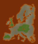
You want your mountains to look real? Real as in how? Contour maps are probably available to guide you, and in contour mapping gradients (even if they aren't exactly standard gradients) are your friends.
If you're just looking for 'real mountain looking icons' then make them in a separate layer and then just select cut n' paste them around like you would if you were using something like CC2, top down and staggered. If I can remember which maps might still have some of mine, I might even grab some up and post them to the cartography thread with the rest of them.
Just a note though, with the stylistic trend of your map I'm not sure if I would bother with putting mountains on there at all. Rivers certainly, but mountains are just going to look weird I think with all that red and they're going to compete with that because they're generally some warm tone. I might just indicate them by font and writing along the spines in a clearly different manner where they are. In any case it's not as if people don't know where mountains are in Europe. I'd say just stick with the cities and roads and rivers, everything else looks like it might look out of place on the tone of your map.


")