Maps by the Artisitcally Declined

Greatwyrm

Been here a while...
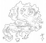
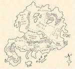
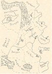
I figured I'd post some step-by-step shots of some maps I'm using for an upcoming game. I'm not really doing this to show off, but rather to give hope to others (like me) who couldn't produce good art if their lives depended on it. I just want to illustrate that you can get reasonably good results without having Photoshop and a degree in illustration.

All of these were hand drawn or traced, as noted below. Then I just scanned them into my PC.

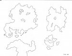
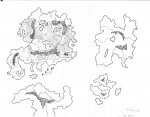
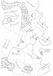
This is the map I started with. It just has the coastal outlines and major lakes.
 

Attachments

  • small coastlines only.jpg
    small coastlines only.jpg
    156.5 KB · Views: 117

log in or register to remove this ad

Greatwyrm

Been here a while...
Next, I used a simple picture editor called irfanview to zoom in on the continent I wanted and copy it to a new map. I printed this out, added the details I wanted with a nice, black pen, and then scanned it back in. Here's what I got.
 

Attachments

  • small domus regoins labelled.jpg
    small domus regoins labelled.jpg
    190 KB · Views: 106

Greatwyrm

Been here a while...
You can see I tried to do some kinda fancy lettering. I know it stinks. You should see my regular handwriting.

Anyway, my next step was to paste that picture into Powerpoint. I used one of the photo tools in PP to make the white sections of the map transparent. Then I went to the Format Picture menu and added a parchment background fill. Finally, I cranked the contrast way up, since the scan was a little fuzzy coming back in.

Here's the finished product. It looks better if you don't let your browser size it for the window and look at it full-sized. Looks okay printed out, too. Unfortunately, my color cartridge is dying, so my players will have to make due with the b/w version until I can sneak this through the color laserjet at work.
 

Attachments

  • domus regoins labelled with parchment.jpg
    domus regoins labelled with parchment.jpg
    65.2 KB · Views: 101
Last edited:

Greatwyrm

Been here a while...
Finally, here's another set of maps I made with the same process. What I needed was a zoom in map of the main campaign area.

I started with a rough political map I already had scanned in. Not at all pretty, but functional.

Next, I zoomed in on the portion I wanted. Pasted to a new file. Printed. Traced the outlines of what I needed. Added the details. Scanned it back in.

Finally, I did the parchment thing with Powerpoint again.
 

Attachments

  • small regions.jpg
    small regions.jpg
    146.9 KB · Views: 69
  • small seven kingdoms zoom.jpg
    small seven kingdoms zoom.jpg
    179.8 KB · Views: 58
  • small seven kingdoms parchment.jpg
    small seven kingdoms parchment.jpg
    68.6 KB · Views: 77

Greatwyrm

Been here a while...
So, there you have it. Nobody is going to be hiring me as a cartographer anytime soon, but they're not bad, compared to some of my past work. I think they'll look kinda cool once I get that parchment background working. Probably ought to add a scale sometime, too.

They're farily easy to produce if you have a decent scanner, a good pen, and some paper. You could probably do much of the same stuff with a copier that has a good zoom function to it and some nice parchment paper.


Remove ads

AD6_gamerati_skyscraper

Remove ads

Upcoming Releases

Top