EN World City Project: Geography

Conaill

First Post
Some more details:

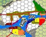
The central island would have been the major river crosing at first. Much easier to cross from shore to island to shore than cross the river all at once. That would also have made the island the prime location to place the tollgate, which eventually grew into the castle.

With the new bridges downstream (and one of them should be called "Newbridge", no matter how old it is ;)) the island obviously no longer serves as toolgate. But if we ever get around to mapping the castle and the island in more detail, there should still be an imposing gate structure on the island

Just thought of something else: we may also want to have a toll gate on the river, for ships passing from the lake (and further upstream?) to the ocean. Again, the central island could (still) fulfill that function.

Once we have the large-scale map more or less worked out, we should proably make a higher resolution one for the city itself.
 

log in or register to remove this ad

The Grey Dwarf

First Post
Conaill said:
According to MMS, a Small City has a population density of 80-120 adults/acre, and 40-60 structures/acre. That comes to a total of about 100 acres (less than 1/2 a mile side-to-side!) and ~5000 structures.
Just checking the conversion tool... 100 acres is a circle with a 360 meter (1200 feet) radius.
This gives us roughly 90 yards per hex on the current map. We should take 100 yards per hex to make for the place taken by the river. What do you think?
Knightfall1972 said:
I agree, it's really important to get the scale of the city and the surrounding terrian correct at this point. We don't want to have to explain discrepencies or "fix it" later.
I totally agree.
Krug said:
Thanks Gray Dwarf for your patience. :D
If I was any good at it, I wouldn't need to be patient. :rolleyes: :D

Jolly, you definitely got yourself the job. :D
If you can come up with a rough sketch of the district repartition and size, mail it to me. I'll do the adjustments to the map.
As for Paint, it's mainly a CopyPaste job.

I'll start to work on the city map right now. I think I'll use Autocad for that. I'll be faster for me.


Jolly Giant

First Post
Gray Dwarf, I'm starting work on a first draft of the districts now. Do you reckon the squats should be within or outside the city walls? Maybe a little of both? Personally, I think it should be outside the walls. Anybody else got any input here?
 

Lalato

Adventurer
Squats... I say outside... near the swamps...

The residents of the Squats have been reporting strange lights coming from the swamps for weeks. No one paid too much attention until people started coming up missing...

--sam
 

The Grey Dwarf

First Post
lalato said:
When someone says Autocad will be faster... That person is way out of my league. :D
--sam
LOL. I've been using it professionally for 10 years before finding a proper job. ;)

The Squats: I would say to start inside along the south palissade and spread towards the swamp. This will be the weak point in the city defences (there's always one!).
 

Jolly Giant

First Post
Ok, here are my thoughts so far. Now let me hear yours! :confused:

I've located the military barracks between the southern and western outlet, and one between the eastern inlet and the government district. Felt this made the most sense, as these are probably the places that needs defences the most. But maybe there shouldn't be more than one of them? Are two one too many?

I've placed the shopping districts along the main roads. That makes the most sense to me.

For the logic behind the other placings, see my previous post.


Mor's End Districts

1) The Squats
2) A mistake. Please ignore!
3) Ships wharfs
4) Old Town
5) Island of Towers, old government district
6) Docks for riverboats between Mor's End and Kul Moren
7) Dwarven town
8) The posh district, full of rich people
9) Port Jollita, the halfling and gnome district.
10) Shopping districts
11) Fishermans docks. Smelly!
12) Wearhouses and docks for trade ships
13) Newer government district
14) Military districts

The rest: Largely residential

Of course, these labels wouldn't be absolutes. That large
portions of the city are called shopping districts, doesn't mean
there aren't any residential buildings there, or that no shops
can be found elsewhere! It merely indicates the districts
dominant feature...

Edit: Seems I can neither draw nor spell! :(
 

Attachments

  • me.jpg
    me.jpg
    33.3 KB · Views: 449
Last edited:


Conaill

First Post
Jolly: it looks like you reversed direction in the river! The river flows left to right: outflow out of the lake is towards the left, ocean is somewhere to the right.

In other words, you're going to have to switch around the location for the Squats etc, and the posh districts!
 

Lalato

Adventurer
This gives us roughly 90 yards per hex on the current map. We should take 100 yards per hex to make for the place taken by the river. What do you think?

One unfortunate thing of a hex being 100 yards is that the river will have to be widen inside the city.


--sam
 

Remove ads

Top