D&D 1E Wilderlands experts?

ilgatto

How inconvenient
Amici,

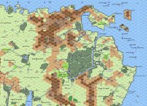
So I've been working on combining all Wilderlands maps into one Campaign Map Zero.

Now, consulting numerous sources I've been able to find what most things on the various maps are, but the meaning of some "entries" on the map for the City State of the Invincible Overlord continues to elude me.

So, does anyone know what the "Demon Tongue" (hex 2904), the "Battleplain Gwalion" (hex 1225), the "North Mantle" (hex 0306-0506), and the "South Mantle" (hex 0112-0212) are? All hex numbers as they are on the original map.

Attachments with maps. Had to convert the files to .jpgs so hope you can still read them.

Thanx.

ilgatto
 

Attachments

  • CM-1-CityState.jpg
    14.1 MB · Views: 49
  • csoi-1.jpg
    csoi-1.jpg
    2.3 MB · Views: 60

log in or register to remove this ad


Dale Libby

Explorer
Demon Tongue: Thirteen miles northeast of Thunderhold, the Rorystone Road turns east to an area of abandoned mineshafts. The area gets its name from the switchback road.

Battleplain Gwalion (Battlefield, EL 8): Legendary site of barbarian and nomad wars. The ground is fertile from spilled blood and contains the remains of many dead. Encounters: ghosts, skeletons

South Mantle (grasslands): A broken wall spans the main pass but the gate was breached ages ago, and smaller ruins dot the region. Huge boulders worked into smooth spheres are found near the ruins. While locals claim that these are the kidney stones of titans, others suspect that they were simply the siege weapons of giants.

Source: Wilderlands of High Fantasy (Necromancer Games)


ilgatto

How inconvenient
Demon Tongue: Thirteen miles northeast of Thunderhold, the Rorystone Road turns east to an area of abandoned mineshafts. The area gets its name from the switchback road.

Battleplain Gwalion (Battlefield, EL 8): Legendary site of barbarian and nomad wars. The ground is fertile from spilled blood and contains the remains of many dead. Encounters: ghosts, skeletons

South Mantle (grasslands): A broken wall spans the main pass but the gate was breached ages ago, and smaller ruins dot the region. Huge boulders worked into smooth spheres are found near the ruins. While locals claim that these are the kidney stones of titans, others suspect that they were simply the siege weapons of giants.

Source: Wilderlands of High Fantasy (Necromancer Games)
Awesome!

Tnx.

Also for pointing out there is a revised later-edition edition. Never knew that.
 

I also have updated Wilderlands maps from Bat in the Attic Games.

I got them from the City State of the Invincible Overlord Kickstarter (of which the less said the better) and it's in my library on Drivethru but doesn't seem to be available on the site itself. I'm not sure if it was Kickstarter patrons only, or if it has since been pulled for some reason.

Necromancer Games/Judges Guild 3rd edition version doesn't seem to be on there either.

And since this seems to have been missed:

North Mantle (Rugged Mountain, high pass/low peak): Once considered the best defense for the plains below, the passes though this rough terrain contain ruined frontier forts. The forts have long since been plundered of valuables, but stories tell of a weird moaning that echoes through the passes if anyone tries to find any lost treasures.
 
Last edited:


ilgatto

How inconvenient
And since this seems to have been missed:

North Mantle (Rugged Mountain, high pass/low peak): Once considered the best defense for the plains below, the passes though this rough terrain contain ruined frontier forts. The forts have long since been plundered of valuables, but stories tell of a weird moaning that echoes through the passes if anyone tries to find any lost treasures.
Thanxalot!

Strange, though, this North Mantle being "Rugged Mountain, high pass/low peak". Map says plains (or perhaps Plateau of Bendigroth). Shouldn't the hex at least have featured hills?

I also have updated Wilderlands maps from Bat in the Attic Games.
Heh. Learning that there was a 3E version of the Wilderlands did make me suspect someone might have made a complete map of the world (Although a quick interwebs search before I started the project didn't reveal any).
Anyway. Not sure if I wanna see that map - at least not right now. My map was literally SOME work and I don't wanna spoil the fun if you catch my drift. :)
 

ilgatto

How inconvenient
So here's an initial version (the jungles still need work and I'm not too happy with the rivers) of the full Wilderlands map - Campaign Map Zero, if you like. Darlene it is not, but I sure was inspired by her.

I've stayed as true the original Campaign Maps as possible, with older maps taking precedence over newer ones.

This means that:

* some names and/or their spelling of others will deviate from how they are given in the various Campaign Installment listings;

* all (possible) spelling errors on the maps have remained, the one notable exception being Harpy Scarp;

* some features had to be moved (e.g., column "52xx" on CM6; several "in-water-lairs" on CM2; sparrows on CM14);

* there is "0000" row between CM13 and CM15;

* only monsters that appear on original maps appear on this one (e.g., Koses, Serd Worms, but not the Lady of the Lake or the Old Man of the Woods);

* all "doubles" remain (e.g., the CM1 row "01xx" and CM5 row "xx34" islands; double villages in overlapping hexes);

* but that I didn't include the Tarantis Islands that have exact duplicates in the Isles of the Blest listing (the "nexus" thing).

Also, the names of a couple of features do not appear in the map, either because I don't know their exact (original) location (e.g., Crespar, Wild Orcs of the Purple Claw, Man'Throp, numerous features that should be on CM6); because of other missing info (e.g., Kingdom of Dolphins, Might [sic] Pentarchy of Am-Rood, Triton Coral Kingdom); or because of a lack of space (e.g., Goblin Reservation, Isle of Lackluster, The Idyllicia and its various features).

The markers should speak for themselves, with "S" being "Special" features found in various JG sources (e.g., Pegasus magazine); "O" being for oases; "D" for dragons; and "P" for pirates/buccaneers.
Note that not all markers point to the exact location of a feature in a hex (coz unknown).

As always, please feel free to point out anything I may have forgotten, as well as any other mistakes.

The exact location of Crespar would be much appreciated.

P.S.: Had to convert the file coz size so there's a .jpg (37.2 MB) and a .png (17 MB). Hope they still work.
 

Attachments

  • CM0.jpg
    35.5 MB · Views: 39
  • CM0.png
    16.2 MB · Views: 36

Remove ads

Top