Jürgen Hubert
First Post
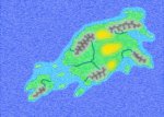
Now open Inkscape again. Create a new layer at the bottom named "BackgroundImage". Go to File->Import and load the map image you have just created. Move it around until the lines of the Inkscape map are directly over the bitmap image.
Now you can place new terrain features directly on top of the main map! You can simply put cities, names, or more intricate features on the map with Inkscape and export it together with the background image, without messing up your existing work and having to do it all over again.
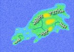
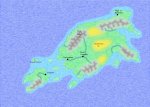
But let's first add some vegetation into the background. Create an additional layer called "vegetation". Since this is supposed to be a simple tutorial, we will only two two different types of vegetation - grassy plains and desert.
Simply draw lines on the land areas depending how you want to divide the land into different vegetation zones. Then save this layer together with the Coastline layer (as usual, make all other layers invisible before saving) as "VegetationLayer.png"
Now you can place new terrain features directly on top of the main map! You can simply put cities, names, or more intricate features on the map with Inkscape and export it together with the background image, without messing up your existing work and having to do it all over again.
But let's first add some vegetation into the background. Create an additional layer called "vegetation". Since this is supposed to be a simple tutorial, we will only two two different types of vegetation - grassy plains and desert.
Simply draw lines on the land areas depending how you want to divide the land into different vegetation zones. Then save this layer together with the Coastline layer (as usual, make all other layers invisible before saving) as "VegetationLayer.png"


")