EN World City Project: Geography

Conaill

First Post
I don't think there's too much terraforming visible on those medieval Dutch maps, I believe that really started much later. They're probably more spread out than your average medieval city though (notice all those gardens and even farmland inside the city walls?)

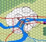
True, Enheim is well above sea level, but for such a sizeable lake I would expect the terrain to be reasonably flat anyway. (The swamp to the south is another good indication.) You can't really deduce the speed of the water just from the width of the river anyway. And you probably need some kind of canyon or seasonal meltwater to create rapids of the kind you're describing. All in all, the current map looks like a rather placid river to me...
 

log in or register to remove this ad

Conaill

First Post
Here's my attempt at a more detailed map of Mor's End.

1: Dwarven Town (away from the water, and probably on a little hill)
2: The Posh District: upstream, near the main trading route, nice view across the water
3: the main Market Square. Right on the confluence of three major trading routes
4: Begger's Market: counterpart of Market Square on the "bad" side of the river. Near the docks and fishing villages
5: The Squats: poor hygiene, extends well past the city walls
6: Port Jollita, the halfling and gnome district. Good water, pictoresque part of town, parks
7: Docks
8: "Mudville": poor quarter near the swamp. Fishing industry
9: NewBridge, built by the merchants guild to bypass the Citadel.
10: Commercial district: industry, warehouses, crafts, some docks
11: The Citadel

Note that I've made some small changes to the map as well:

1) I made the traderoute south of the river more important. If Mor's End started as an important river crossing, it seems like it would make most sense if the major trade route came from the left, cross the river at the Citadel, and continued south of the river.

2) I made the "Island of Towers" smaller, mainly to make it harder to cross the river there (leaving Citadel island as the first choice for river crossing).

3) I replaced the southernmost bridge by a ferry Seems to make more sense, because we would need a very long and high bridge there otherwise. There's probably plenty of ship travel between Port Jollita and the docks anyway.

4) We may also want to move the city walls in a little on the Southeast part of the river. There's no need for the city walls to line up on both sides, and the city fathers wouldn't want to spend too much money protecting the slums anyway
 

Attachments

  • morsend.jpg
    morsend.jpg
    112.4 KB · Views: 259
Last edited:

Conaill

First Post
Another exercise in applied demographics:

How big are the slums?

"Magical Medieval Society" lists "beggers" as the single most frequent profession, with an incidence rate of 1/7. That's a total of 1460 beggers in Mor's End. It also lists shanty towns and slums as being the densest parts of town, with 58-60 structures/acre and 116-120 adults/acre. That makes about 12 acres, or ~ 1/8 of the city


wizardoftheplains

First Post
Since their are rare clay deposits nearby, where are they on the map?
Was the who area under water at one time and did the lake drop? OR
Since rivers meander over time, is there a dry river bed that the inhabitants dig into for clay?
And do the rare colors of clay come from a source deep beneath the lake?
Just some thoughts.
 

Conaill

First Post
I guess the clay deposits could be on the "big island" west of the city. Mainly because I can't think of any other good reason why the city didn't develop any further on the island instead. ;)

Anyone know a real geologist that we could consult on stuff like this?
 

Shadowdancer

First Post
I think the city looks great so far. A couple of suggestions:

A foreign quarter or district. With all the trade coming into town, there are going to be lots of foreigners. The city rulers would likely want them concentrated in one area so they can easily keep an eye on them.

A university quarter or district. Again, as a major trade center, the city is likely going to attract people who would start various types of schools -- wizard school, bard school, mining school. Maybe even a school in which classes in pottery making are not an easy "A" for athletics to bump up their GPA. :)
 

Jolly Giant

First Post
Conaill said:
Here's my attempt at a more detailed map of Mor's End.

1: Dwarven Town (away from the water, and probably on a little hill)
2: The Posh District: upstream, near the main trading route, nice view across the water
3: the main Market Square. Right on the confluence of three major trading routes
4: Begger's Market: counterpart of Market Square on the "bad" side of the river. Near the docks and fishing villages
5: The Squats: poor hygiene, extends well past the city walls
6: Port Jollita, the halfling and gnome district. Good water, pictoresque part of town, parks
7: Docks
8: "Mudville": poor quarter near the swamp. Fishing industry
9: NewBridge, built by the merchants guild to bypass the Citadel.
10: Commercial district: industry, warehouses, crafts, some docks
11: The Citadel


Good stuff, Conaill! I can't believe I got the river the wrong way around when I did my map... Guess I read the boards a little too quickly before going to work. :rolleyes:

I like what you've done here, but I have one small objection: There's probably been fishing going on in the river for as long asa there've been people here. The fishermens docks were very likely the first kind of 'industry' to settle in, so shouldn't they be quite close to the original town site? Yeah, sure the place is smelly, but it was there before everyone else...
 

TGD@work

First Post
So, looks like nice work up there. I'll have a closer look tonight.
In the meantime, here's a little someting to occupy your bubbling minds.

-----------------------------------------
The city started out on the side of some tall mountain, within a mountain pass that had a river flowing through it (Fig.1).

continued next post...
 

Attachments

  • cut001.jpg
    cut001.jpg
    11.8 KB · Views: 239

TGD@work

First Post
The mad mage Gyrygax (LN) (alt. Gydoh Plagax) had appointed himself protector of Enheim. Seeing the corruption and the chaos reigning in the city, he set out to teach the people the ways of the law. He was ignored at best. After being told once too many to "f### off", he blew it, he constructed the Unseen Dam to drown all that filth.

The slow rising of the water allowed the people to calmly pack their things and move upwards along the mountain, ruining the Demented One's plan. Out of sheer rage, Gyrygax blasted the top of the mountain the people were climbing, hoping that the rocks would crush them. This was only marginally more successful as only 100 people or so were hurt by debris, the main part of the rock having simply vanished. The people were thus supplied with a new place to create the city (Fig.2).

The city was still threatened by the rising of the lake. As the water found new exits and two rivers started flowing towards the east, one of which is still trying to cut new ways thus creating a swamp south of the city. To restrict the expansion of the swamp, the leaders of the city hired a powerful mage to create a small breach in the Unseen Dam. This allowed the regulation of the water level and recreated the original river flowing to the south. They didn't want to remove the dam because the lake had become a endless source of income for the community.

It is rumoured that Gyrygax is still looking for another Ring of Wishes to "finish them off this time". There is also a sect of followers of "Gyrygax the Creator" who work in the shadows to bring some order to the city.
 

Attachments

  • cut002.jpg
    cut002.jpg
    11.8 KB · Views: 231

Remove ads

Top