• The VOIDRUNNER'S CODEX is coming! Explore new worlds, fight oppressive empires, fend off fearsome aliens, and wield deadly psionics with this comprehensive boxed set expansion for 5E and A5E!

What's a good fantasy mapping program?

DM Howard

Explorer
Here's another vote against CC3 and it's add-ons. It just simply doesn't do a good enough job (for me) compared to the work I have to put into it. I've settled on the Hex mapping programs mentioned above as it leaves a little to the imagination, looks nice, and is pretty easy to learn.

Edit: That being said, I do enjoy CC3 for maps that I will get a large amount of use out of, but for maps that I'll probably only ever use once, the work:time ratio seems to steep. It may be that I'm simply not super proficient at it yet I'm willing to admit.

Edit #2: I've recently been giving GIMP a go and I'm pleasantly surprised that I'm getting a very good look out of it compared to the effort I'm putting into it. No, it's not a mapping program, but I've found it allows a better amount of customization for what I need. The learning curve is steep, like other programs, but makes more sense to me at least.
 
Last edited:

log in or register to remove this ad

DrunkonDuty

he/him
I've put a lot of time into CC3 over the last couple of years. Now I can get it to most of what I want without to much effing about. But it took some time to get there, even with the tutorials. What isn't really discussed in the tutes is that you have to do things the way the program wants them done. It will auto select sheets when you choose a symbol set. Lakes were a total PITA. What isn't mentioned (until something like the 11th tutorial) is that when you look at the sheets list the sheets are in reverse order of what is seen on the map (lower in the list, higher on the map picture.) I kept wondering where my lakes vanished to. And judging by the queries on the CC forums I was far from the only one.

Now, as I said, I have put a lot of effort into it and eventually I have gotten used to it. I have paid the cash and am going to stick with it. But unless you are used to AutoCAD drawing already or have plenty of time to learn or enjoy the challenge of learning new software, I would not recommend CC to someone who just wants to get on with the map making.

But I'm still not happy with the final resolution of the maps that get exported (as JPEGs, et.al.) No matter what I try the resolution is poor. WizardDru if you have any tips for improving thatI'd love to hear them.
 

gamerprinter

Mapper/Publisher
But I'm still not happy with the final resolution of the maps that get exported (as JPEGs, et.al.) No matter what I try the resolution is poor. WizardDru if you have any tips for improving thatI'd love to hear them.

And it takes forever to export a file, especially a large map - and almost impossible to export at anything higher than 72 ppi.
 

DrunkonDuty

he/him
And it takes forever to export a file, especially a large map - and almost impossible to export at anything higher than 72 ppi.


Yeah, the 72ppi is a problem. There was a suggested work around (exporting "views" IIRC.) I tried it but didn't get any better resolution.


gamerprinter

Mapper/Publisher
Yeah, the 72ppi is a problem. There was a suggested work around (exporting "views" IIRC.) I tried it but didn't get any better resolution.


All the inefficiencies of applications like Campaign Cartographer is the reason I prefer working with a vector drawing/desk top publishing program to do my mapping instead of any mapping specific application. As stated, I use Xara Photo & Graphic Designer 9 ($89) which allows you to create greeting cards, flyers, brochures, signs, posters (any standard graphics uses), but is also a superior mapping application (although only me, and those I introduce the software ever actually use it for mappping).

XP&GD9 allows me to create shapes, apply bevels, shadows, transparency, edge feathering, infinite layers, infinite undo (even files that are saved, you can reopen and undo anything you did before saving the file even from the first step applied.) Because it is vector, I generally use inches to define a map size and never consider the pixel resolution until I finish the map, and am ready to export it to whatever format best fits my needs. Because it is a vector program, anything created can be reduced or enlarged, even the entire map, and can subsequently export to any resolution from 1 ppi to 300 ppi, even export multiple resolutions from the same original file - so I can use it for Roll20 or print in high resolution. Any tool used, the applied result is almost instant (Xara is one of those programs that most efficiently minimizes memory usage - it is not a memory hog.) Exporting a large map design to large format and high resolution is very fast, almost no waiting at all.

You can view the maps posted in my Gamerprinter's Map Emporeum thread (Miscellaneous Geek Talk and Media Lounge forum) - all of them were created in one edition of Xara or another (I've upgraded my software since December). Most of these maps one might not consider to be a vector created map, but they all are.

Really, because it is so easy to learn and use, I find no other program better at creating maps than Xara, and I'm including all mapping applications (CC3, Dundjini), image editors (Photoshop, GIMP), vector drawing apps (Illustrator and Inkscape) in that comparison - I've used all those applications.

And scheduled for August 2014 release are 4 map tutorials guides I am in the process of writing following a successful Kickstarter to fund their creation. Although I offer primer instructions for using the guide with Photoshop, GIMP, Inkscape, Illustator and Xara Photo & Graphic Designer 9 - all the included maps, the tutorials and the page layout for all the guide books were done in Xara. You can view the KS to learn more about this project here, or visit my G+ community dedicated to the same project.

Also consider that I am a professional RPG cartographer (I even created the original hand-drawn map of the City of Kasai for the Jade Regent AP by Paizo) and created 189 of the map objects found in the ProFantasy Modern Symbol Set accessory for CC3 and related software.
 
Last edited:

DrunkonDuty

he/him
[MENTION=50895]gamerprinter[/MENTION]

You've convinced me to give Xara a try. :)

Now I'm not a graphic designer but I am a video editor and I do do some work with titles and such forth. And as far as I can see vector graphics is the only way to go.* So I was surprised when I got CC3 and discovered it isn't vector graphic.


*I do vaguely recall being taught 20 years ago that there are reasons to use non-vector graphics, I just can't remember them.
 

gamerprinter

Mapper/Publisher
[MENTION=54364]DrunkonDuty[/MENTION] - I hope you like it. Check out the basics tutorial videos posted on the Xara site, check out the rough draft tutorials on my G+ community, ask any questions there if you have them.

If you want to use some cool free photo-realistic textures, get a free account to download 15 MB of image files every week at Cgtextures.com

I may have missed it, but which of the mentioned programs is good t mapping a city? I'd like to finally make a map of crystalshore. My only issue is the program needs to be free due to my non existent budget.

While I don't use this to create my city maps, per se, I do use it to get ideas on street plan layouts. Here is a freeware application called the Roleplaying Game City Map Generator.

It has setups for African village, viking village, old west town, European style city, US style city, thorpe to city. You can define parameters for city walls, wall thickness, towers, gates, number of bulidings (population size), building size variance, distance from streets, include rivers/waterways, set size and number of parks, etc.

Once you set your parameters, hit "Go" and it generates a random city plan. If you don't like the result, hit "Go" again and again until you get something you like. Its pretty cool for a free app, though its for Windows only.
 
Last edited:

While I don't use this to create my city maps, per se, I do use it to get ideas on street plan layouts. Here is a freeware application called the Roleplaying Game City Map Generator.

It has setups for African village, viking village, old west town, European style city, US style city, thorpe to city. You can define parameters for city walls, wall thickness, towers, gates, number of bulidings (population size), building size variance, distance from streets, include rivers/waterways, set size and number of parks, etc.

Once you set your parameters, hit "Go" and it generates a random city plan. If you don't like the result, hit "Go" again and again until you get something you like. Its pretty cool for a free app, though its for Windows only.

thanks :) i'll give it a try
 

gamerprinter

Mapper/Publisher
thanks :) i'll give it a try

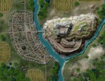
As stated, I only use it for ideas, but also as stated I use Xara, a vector app to create my maps, including city maps. Here's a recent city map and castle I created with Xara. Note, I used photo realistic textures for the 'color'. Also, note, I create all my map objects - buildings, trees and such with Xara as well.

castle-town-800.jpg
 

SkidAce

Legend
Supporter
[MENTION=50895]gamerprinter[/MENTION]

You've convinced me to give Xara a try. :)

Now I'm not a graphic designer but I am a video editor and I do do some work with titles and such forth. And as far as I can see vector graphics is the only way to go.* So I was surprised when I got CC3 and discovered it isn't vector graphic.


*I do vaguely recall being taught 20 years ago that there are reasons to use non-vector graphics, I just can't remember them.

CC3 is vector graphic based. It's developed from a CAD program. Bitmap fills and non vector icon symbols have been added, but its definitely vector based.
 

Remove ads

Top