• NOW LIVE! Into the Woods--new character species, eerie monsters, and haunting villains to populate the woodlands of your D&D games.

Map of Campaign World - Feedback?

Esteban

Explorer
Hello,

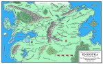
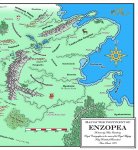
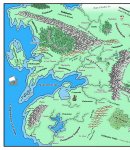
Wanted to post the map of my campaign world and get some feedback. Most of the map was drawn out by hand, scanned in, then modified using Photoshop. I'm happy with the results, but would like to get some feedback from the forum.

I've attached 3 images (though I had to reduce the size and quality somewhat because of the forum's limits on file size). The 1st image is reduced copy of the full map, the second image is a full sized copy of the eastern section, the 3rd is a full sized copy of the western section of the map.

Anything anyone would have done differently? Is there too much detail, not enough?

Thanks,

-Steve
 

Attachments

  • enzopea_fullreduced.jpg
    enzopea_fullreduced.jpg
    222.8 KB · Views: 219
  • enzopea_east.jpg
    enzopea_east.jpg
    205.9 KB · Views: 161
  • enzopea_west.jpg
    enzopea_west.jpg
    228.6 KB · Views: 144

log in or register to remove this ad


pogre said:
Did the mountains and trees come out of CC?

The maps really look like CC maps to me.

They look very professional.
Thanks for the feedback.

Both the trees and mountains were drawn by hand. In the case of the trees, I drew around 10 or 11 trees, scanned them in, colored them using PS, then reduced their size. I then copied each one as a separate layer and combined in various ways to make my forests.

I do own CC but sort of gave up on it due to the high learning curve. Also like using hand drawn elements in my maps to give them more of a 'fantasy' feel.

-Steve
 

Wow! Great Job! I'm working on a campaign map from time to time. I'll be pleased if it looks half as good.

I love the little "pope-like" guy.

Where did you get that font? Please do not tell me you hand-lettered it!
 
Last edited:

Esteban,

Great looking maps. Overall it is top-notch stuff but here are a few suggestions for you to consider.

1. The map has the same solid green base throughout. Most maps have browns, yellows, and tans faded in to note terrain/climate. I think adding some of this (which you seem very capable of since it is already done in the rivers and artic areas) would really make the map pop.

2. Fade the lighter blue costal regions into the darker blue sea....ditto for the lakes.

3. Rivers that come off mountains are strait and fast unless there is a strange mitigating factor - meandering loopy rivers are slow lazy affairs.

4. Generally speaking only one side of a mountain chain will be "wet."

5. This one is sheer taste - you don't have enough trees on the map. I think a few (6-10) more small forests would look nice in the south.

I will re-iterate that this is a good map and the suggestions are just a little feedback for you.

PS - the symbols say "CC2" but the map hollers "Photoshop."
 
Last edited:

pogre said:
Wow! Great Job! I'm working on a campaign map from time to time. I'll be pleased if it looks half as good.

I love the little "pope-like" guy.

Where did you get that font? Please do not tell me you hand-lettered it!
Thanks!

No, I didn't hand letter. The larger font that I used is called Sherwood, the smaller font that I used is called Chaucer.

Not sure where I got those fonts. Let me know if you would like them and I'll email them to you.

-Steve
 

Eosin,

First off, thanks for the feedback!

Agree with you about the solid green base throughout. I'll go ahead and modify. Same with the oceans.

You also wrote:

>3. Rivers that come off mountains are strait and fast unless there is a
>strange mitigating factor - meandering loopy rivers are slow lazy affairs.

This was more of a style thing. I had looked at regular maps and started drawing my rivers that way, then decided that meandering rivers just looked - better. ;)

>4. Generally speaking only one side of a mountain chain will be "wet."

Hmmm, so major river systems shouldn't emerge from both sides of a mountain chain? I may modify my map accordingly. The rivers may be stylized but, overall, I would like things to be geographically accurate (at least somwhat anyway).

-Steve


Ferret,

In PhotoShop, I used fills for the main portions of the map then used PhotoShop's airbrush tool to paint the colors for the hills and mountains and the dark green areas around the rivers. The airbrushing was time consuming but I'm happy with the final result.

-Steve
 
Last edited:


Into the Woods

Remove ads

Top