
Oscaron
First Post
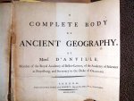
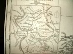
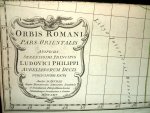
I thought I might share a few photos of an Atlas that came into my possession a few years back.
It's a 1775 Complete Body of Ancient Geography by Jean Baptiste Bourguignon d'Anville, Royal Cartographer of France.
You can read a bit about him at http://en.wikipedia.org/wiki/Jean_Baptiste_Bourguignon_d'Anville if you wish.
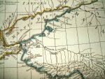
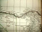
Anywho, I know it's a bit later period than the Middle Ages that Fantasy Genre's tend to emulate, but since there is also a bit of technology in most Fantasy settings, above and beyond historical levels, I figured it was not beyond the pale that cartographic tech might be along these lines.
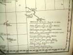
The atlas was produced with the copper-engraving method and borders were then watercolored by hand.
The finished maps unfold to roughly 2.5' x 3' and are attached to a tag then sewn into the atlas by the tag.
I hope it's of use to someone.
As foir me, when I finish my own maps for a personal project of mine, I may attempt to create a historically accurate build of an atlas just to say that I've done it.
Osc
It's a 1775 Complete Body of Ancient Geography by Jean Baptiste Bourguignon d'Anville, Royal Cartographer of France.
You can read a bit about him at http://en.wikipedia.org/wiki/Jean_Baptiste_Bourguignon_d'Anville if you wish.
Anywho, I know it's a bit later period than the Middle Ages that Fantasy Genre's tend to emulate, but since there is also a bit of technology in most Fantasy settings, above and beyond historical levels, I figured it was not beyond the pale that cartographic tech might be along these lines.
The atlas was produced with the copper-engraving method and borders were then watercolored by hand.
The finished maps unfold to roughly 2.5' x 3' and are attached to a tag then sewn into the atlas by the tag.
I hope it's of use to someone.
As foir me, when I finish my own maps for a personal project of mine, I may attempt to create a historically accurate build of an atlas just to say that I've done it.
Osc
")


