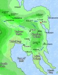
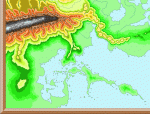
Beautiful maps! I've never played with CC2 - how much input do you have on the geography? For example, that big linear mountain chain in the 3rd out of 4 maps seems very artificial or magical in origin. Did you specify that one by hand, then let the program for a fractal terrain around it?
Just a few nits to pick, because I can't help myself
")
:
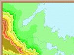
- The abrupt breaks in the color gradients really detract from the realism and interpretability for me.
- Assuming you have some choice over where the rivers are located... I've noticed a tendency for your rivers to start at the top of a mountain peak, especially on the first of your 4 unlabeled maps. That doesn't seem quite right to me. Firstly, the river should start near the center of a local watershed basin, not on top of the peak itself. Secondly, that close to the peak, the "river" would only be a small seasonal gully. If you want to draw the rivers down to that scale, you should draw all the other foot-wide tributaries as well, which is impractical.