How detailed are your wilderness/overland maps?

This is a little off-topic, but I think worth discussing here:

On the subject of describing nearby terrain to the PCs, as far as I can tell you can see major features (such as mountains) from about 40 miles away, assuming you have a clear line of sight. Perhaps further for taller mountains, but at 40 miles they're looking purple and indistinct, no matter how tall they are. It's also difficult to estimate if the particular mountain is a really tall, distant mountain, or a closer, shorter mountain. I'm trying to make it simple, if not purely accurate.

So, if mountains are generally visible on the horizon at 40 miles, then other terrain features are probably visible at about 20, if you're standing on flat ground. That's my rule of thumb, just for the sake of having one. It ain't perfect, but assuming that the characters are in reasonably clear terrain, that's what I consider the limit of their major-terrain-features vision. That dark patch is probably a forest, that glinty thing is probably a lake, a bit of haze over there suggests smoke from a small town, etc...

Of course, if they're in the middle of swamps, woods, hills, mountains, etc..., their vision could easily be significantly reduced.
 

log in or register to remove this ad

Wolffenjugend said:
Where do you get them from?

(This is about "real world" maps)

Usually from the local library - I find books discussing the area I'm interested in, and odds are I'll find a few with maps that I can copy. As a bonus, there's often lots of adventure ideas.

Another good source is the web. For example, the U.S. Geological Survey has a neat website:

http://www.usgs.gov/

... with lots of maps, including an interactive map of the continental US that can be zoomed in and out to get the level of detail you need.

Another good site is GeoConnections:

http://www.geoconnections.org/CGDI.cfm/fuseaction/home.welcome/gcs.cfm/index.html

... which is part of a Canadian government project. This is a better source for ordering maps than viewing them, but does have some good info and links to online atlases and such.
 

For wilderness - I have a HUGE world map that I made on a huge hex grid (it folds out to the size of a regular map like you'd get from AAA). I drew it out, based on fault lines discerned from dropping a hard boiled egg and using the cracks on it. Then I drew the moutains and the edges of the main continent (which is what the map really is of - it is probably only 1/2 of the actual world). I colored it all in with colored pencils. It looks rather nice. I then added countries and cities and other details that I planned, and I continue to add detail as parts of the map are "explored" - so there is always room to modify it, though the basic terrain features are all set, such as rivers (which flow from mountains to sea, generally, all set by the egg fault-lines).

I note details on the maps as I think of them. Sometimes I'll draw "zoom in" features, but generally, I keep the details pretty sketchy - a wilderness trek will include some random encounters, but I'll also make up more substantial things along the way as well. If the players really showed an interest in exploring an area, I'd probably make something up on the fly if there wasn't already something there, and then continue to detail the area more as the sessions stayed there. In this way, I've managed to build up quite an interesting geography of cities, castles, ruins, and other features - some planned, some from spontaneous exploring.

A world map can be VERY VERY big and cover a lot of area, so one will never have everything exactly set - even if you think you do, in "reality" there would probably be even more details there that you had left out, if you were so inclined to expand on it later.
 

I have three kinds of maps: Continent, Region, and Player.

The continent map is on one US Letter size sheet of graph paper (5x5), and consists only of an outline of the coasts. I then have several transparent overlays that I put on top of it. The overlays are: vegatation, climate, hills/mountains/waterways, prevailing winds and ocean currents, and political (with trade routes and symbols for mines and other natural resources).

Region maps show areas that are roughly 1 month by 1 month across via horse back. I used to just arbitrarily draw them based on my needs for the next game. Recently, I have been redoing these using the blank map sheets Jolly Blackburn provided over at the Kenzerco site (they are the same sheets used for the Garweeze Atlas.)

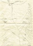
The player maps are drawn with pencil and charcoal on rough packing paper. See the attachment for a scan of one of the crappier ones I provided to the players early on.
 

Attachments

  • map1a-b-s.jpg
    map1a-b-s.jpg
    237.2 KB · Views: 85

Remove ads

Top