It was hand-drawn at first, then scanned. Then I realized it looked too much like Europe (try cocking your head to the left a bit, and mentally connecting Risur to the rest of the continent. Danor is England, Risur is France, Drakr is Germany, Crisillyir is Italy, Ber is Spain, and Elfaivar is Turkey.
So I erased all the landmarks and used photoshop to tilt the image slightly. So now it looks like Europe and Africa, but oh well. I've got another setting,
here, that looks a lot like North and South America.
I redrew the mountains and altered a few coastlines with photoshop, then added text and shading. I'm planning to put up a campaign website with dynamic links from the map to pages with descriptions of each area,
here. But I've just been playing around with image mapping so far, with no actual descriptions yet.
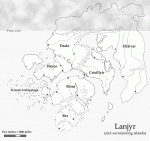
Northeast Crisillyir is very flat and dry, and the sectioned-off areas are separated from the mainland by water that's only ten or fifteen feet deep. The ground there is just cut open by any sort of water current. The Risur inlet, though, is a snafu on my part. But I don't mind it. I'm sure there's more unlikely stuff in the real world.

 The VOIDRUNNER'S CODEX is coming! Explore new worlds, fight oppressive empires, fend off fearsome aliens, and wield deadly psionics with this comprehensive boxed set expansion for 5E and A5E!