Campaign Map - Feedback Requested

Esteban

Explorer
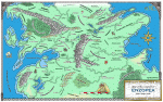
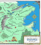
About 8 months ago, I posted to this forum with a map of my campaign world asking for some tips and ideas on how to improve it. I got some great suggestions, many of which I incorporated into the map. I finally got the map completed and wanted to post again to get some feedback on the final result. Because of the filesize limit on ENWorld, I've created 3 images. The first is a reduced image of the full map, the second is a more detailed image of the western part of the map, the third a more detailed image of the eastern part.

Also, has anyone had a map or other photoshop image printed out at a copy shop like Kinkos? If so, in what format should I save the file when I take the map file to get it printed. Should I save it as a TIFF, BMP, JPG, or something else?

Thanks,

-Steve
 

Attachments

  • enzopeareduced.gif
    enzopeareduced.gif
    235.2 KB · Views: 145
  • enzopea_east.gif
    enzopea_east.gif
    238.8 KB · Views: 137
  • enzopea_west.gif
    enzopea_west.gif
    240.8 KB · Views: 139

log in or register to remove this ad


Great job on the maps Esteban. I can see that you primarily used CC2 for the creation of the maps. It appears that you did some touch up on the maps also. If so, what did you use?
 

Wonderful maps.

I don't think the "Art Gallery" has file size limits, you can post there and link to image.

As far as I know Kinko's will handle every type but call them and ask, you may also want to check and see if they laminate (sp).
 

Alisanos said:
Great job on the maps Esteban. I can see that you primarily used CC2 for the creation of the maps. It appears that you did some touch up on the maps also. If so, what did you use?

Thanks for the feedback. Actually, I didn't use CC2. Initially, I hand drew the coastline, rivers, hills, and mountains. I then scanned the image and imported it into Photoshop. Using Photoshop, I added text, coloring, and some clipart images.

I also drew out some images and trees and scanned them in. I then used Photoshop to scale down and color. In the case of the trees, I created around 12 trees and copied and pasted to create forests.

-Steve
 

Very nicely done. I was impressed when I thought you used CC2 for the maps. I am more impressed to find out that it was hand drawn and touched up with Photoshop. Keep posting your work. I would love to see more.
 

Very nice.

I only have one comment; that the Micklespine Mountains ought to have a forest on their western foothills. Oh, and the Moldava Mountains ought to have a bit of forest on either side, but not a lot.

Otherwise, very nice. I like the regional names especially; it's nice to see germanic roots instead of the cliched latin and modern english.
 

Very nice maps!

Kinkos will be able to handle all the major image formats. You might want to check out other printing services, including online ones. You can find it for a lot cheaper than kinkos (like $6/sq ft as opposed to $10/sq ft).

One tip: When you're finished in Photoshop and want to convert the document from .psd to something more useful, consider using PNGs. They're like GIFs but better, and they don't loose image quality when you compress them. Their file sizes aren't as small as Jpegs, but jpegs loose quality as you shrink them.
 

Galethorn - Why do you think that the Micklespine Mountains ought to have a forest on their western foothills? Is it your personal opinion based on aesthetics or is does it have something to do with geography/geology? Just curious. Thanks.
 

Alisanos said:
Very nicely done. I was impressed when I thought you used CC2 for the maps. I am more impressed to find out that it was hand drawn and touched up with Photoshop. Keep posting your work. I would love to see more.

Alisanos,

Thanks again for the feedback! I'm going to take "Hand's" advice and go ahead and start putting the maps in the art gallery. Should have a new kingdom sized map for my new campaign completed by the end of the month.

-Esteban
 

Remove ads

Top