• The VOIDRUNNER'S CODEX is coming! Explore new worlds, fight oppressive empires, fend off fearsome aliens, and wield deadly psionics with this comprehensive boxed set expansion for 5E and A5E!

I need tips for drawing maps!

blackshirt5

First Post
Basically, I'm just looking for somebody who can draw a good map to give me a few tips. I'm trying to draw an overworld map before my next session, that way I can have something to reference(also to point to when they(my players) are doing overland travel, so that they don't get confused).

Also, if anybody has any tips for drawing cities and towns(I don't have any mapping programs on my computer, BTW, I prefer to do a lot of my D&D prep work by hand, usually at night sitting on my bed), they'd be appreciated too.
 

log in or register to remove this ad

Hand of Evil

Hero
Epic
You don't need detail. Don't make it too big.

Eye ball your scale, 1 inch on the paper equals X number of miles or X number of days. 120 miles or 12 days.

Draw things in the following order:
Coast
Mountains
Rivers
Cities/ruins/places
Swamps/special landscapes
Roads
Forest
 

Terry Edwards

Registered User
making maps

Start on a broad scale blocking out the various land features first with a hard pencil (that is draw a series of connected shapes each labeled with the terrain it will be). Know what style you will use for each terrain type and practice drawing it before you begin filling in the blocked out areas. Use a softer pencil to fill in the blocked sections and label where needed. Pen over the terrain then erase the pencil for a nice neat map. For beginners I suggest using published maps for reference until you develope your own style.


Pax

Banned
Banned
blackshirt5 said:
Also, if anybody has any tips for drawing cities and towns(I don't have any mapping programs on my computer, BTW, I prefer to do a lot of my D&D prep work by hand, usually at night sitting on my bed), they'd be appreciated too.

The best city maps I have managed to draw have taken not one, but SEVERAL maps ... drawn in chronological series.

Draw the city/town as it was when the first habitations were built there -- even if that was all of a tower and bridge, with a couple houses nearby. Don't be ultradetailed; roughly block in the buildings, zones, etc. If something is a farm field, label it "Farm"; if it's the village commons or local barracks' parade grounds, label it accordingly.

Fast-forward to the next "stage of development" -- a full village or small town, perhaps. Figure out which, if any, roads have been paved. Decide how any fortifications the aforementioned tower-and-barracks) might have been expanded -- or even mvoed. Write up a couple sentences regarding local history.

Lather.

Rinse.

Repeat.

:)

I did this once, over a series of some 15+ maps, for a smallish city; I ended up with a VERY pleasantly organic city; you had cemeteries inside the city limits, neighborhoods of differing age (some old neighborhoods were wealthy neighborhoods, occupied by families who'd been present, and prosperous, throughout most of the city's history ... SOME older neighborhoods were little better than falling-into-ruins slums ... and so on).

It's a LOT of work, but it also gives you a good idea where there might be additional stories waiting to unfold (the "church tower" inside the cemetery along Temple Street is really the uppermost floors of the old, long-ruined tower from teh tower-and-bridge days; though the river has, in teh thousand years since then, shifted it's course several hundred yards away ... so what people THINK is the "Old Bridge" is, in fact, a wholly different and newer structure ... under the semiruined tower of the old "Soldier's Chapel" in the old cemetery, the old barracks' underground workings still exist ... perhaps leading to a small series of caverns, contianing some treasure or other, etc, etc).
 

Scorpio

First Post
Send a blank e-mail to maps@roleplayingtips.com , and you'll get 100-odd map links I edited for Johnn Four....a bit of everything there!(Including AutoRealm)....
 

Attachments

  • mmbanner.jpg
    mmbanner.jpg
    37.1 KB · Views: 138


WayneLigon

Adventurer
RangerWickett said:
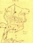
Well, here's a map I drew for my campaign. The link to the storyhour is in my sig.

Very nice map!

Blackshirt5, notice some significant things that RangerWickett includes; these should help and are really self-evident after you think about it.

1. Rivers flow from mountains to the sea; i.e. from higher to lower elevations. Rarely will they ever cross other mountains or hills. If they do, there will be a really large canyon or split there; commonly, the second set of uplifts will be significantly lower than the first. A river can also 'disappear' and go underground for a time, though this is pretty rare. Note that Toliien does this with (I think) the Sirion; pretty neat effect.

2. Cities grow up first around rivers, lakes and oceans. Rivers = interstates; they are used to move goods around.

This Maps Workshop also has some good points.
 

Remove ads

Top