EN World City Project: Geography

Bridge Placement?

Ok, just to let you all know - it's very simple to modify things in CC2 but will become harder to change as more feature are added. Thus, if no one objects then how about using the following layout for the bridges:
 

Attachments

  • mors_end2.jpg
    mors_end2.jpg
    95.4 KB · Views: 181

log in or register to remove this ad

Hah! beat me to it... :) See my updated pic above yours.

You bridge labels are a little off. What you call Quaybridge is Highbridge, and what you call Highbridge is Newbridge.

Note that I also changed the width of some of the roads. The main trade route (and thus widest road goes across Oldbridge and Highbridge (called Quaybridge on your latest map), and has only recently been bypassed by Newbridge in the East. Port Jollita probably wouldn't have any roads quite as big as that, and the only large roads on the SE side of the river would be trade road, forking towards Highbridge and Newbridge. The roads leading out of the NE and SW city gates are probably minor (in comparison with the main trade route anyway), as is the one heading S from the SE gate.

I also shortened the span for Highbridge a little (extended the SE end of the city towards the Citadel), and widened river mouth a little where the southern bridge used to be on your map.

If this makes it easier, here's a little difference map between my version and your old one:
 

Attachments

  • mors_end_diff.gif
    mors_end_diff.gif
    25.2 KB · Views: 198

Mor's End - Version Three

Ok, moved the labels around, as well as naming the different gates and adding a gate in the north. Both Northgate and Eastgate are smaller than the other gates. I also added district roads. The main roads are now 18 feet wide while most of the secondary roads are 10 feet wide (roughly).

Traders' Way (known as Traders' Road outside of the city) comes through Tradegate then goes north over Newbridge and then west to Westgate.

I forgot to label the different markets but that's ok. I'll do that during the next update.

The small island dedicated to the mysterious wizard of Mor's End is named Mage's Roost, which I thought sounded cool.

Also, are all the bridges made of stone?

Anyway, opinions please.

KF72
 

Attachments

  • mors_end3.jpg
    mors_end3.jpg
    111.2 KB · Views: 195


KF... that's some nice work...

Here's some stuff to work on...
I think the caravans would be heading East... not West... so EastGate would be larger than WestGate.

As for the bridges... I like the idea that they are not all stone. I know New Bridge is definitely stone (designed by dwarves)

Here's a breakdown...
New Bridge - stone
High Bridge - wood and stone
Old Bridge - wood and stone
Jollita Bridge - wood

I think the road from the Jollita Bridge should go around the building instead of through it... That way you can close off part of the building from the roads.

--sam
 

Cool! Staring to look better and better, Knightfall! :)

Oldbridge and Highbridge are the oldest bridges in the city, and thus definitely made of solid dwarven stone. Newbridge is fairly new and made of cast iron, a marvel of modern dwarven engineering. (Newbridge should also be the longest bridge in town, only a little shorter than Oldbridge and Highbridge combined. Any chance of narrowing the river a little at Highbridge?) The other bridges... don't know. Probably stone, I would guess. We don't want to stray *too* far from the medieval city. One cast iron bridge is plenty. Depending on where we place the Glazers, one of the bridges may even be glazed clay bricks, but I don't think we need to go into that kind of detail right now.

I would still move Tradegate further East, but I'll leave that up to you. Dunno how hard it would be to change at this time. (Moves the trade route farther away from the dangerous swamp, and allows us to connect the Squats with the Squats-beyond-the-Wall further downstream.)

Knightfall, how hard would it be to randomly populate these streets with buildings? Is CD2 up to something like that? Or would you need to do lots of work by hand for each individual street? We don't really need to draw in the buildings (all 5000 of them! ;)), just curious how powerful this feature is...

The scale in the bottom right is rather hard to read. I'm still wondering exactly how large things are on this map, which is going to become more and more important as we add more detail.

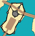
Here's a closeup of how I see Citadel Island. It grew out of the toll gate straddling the trade route in between the two bridges. Then a keep got built next to the toll gate (that's the actual Citadel), and the NE part of the island got split lengthwise into two courtyards where trading caravans can gather before crossing the toll gate. The keep grows as more administrative offices get added, and eventually the entire island gets a curtain wall. I've drawn in a parade ground for official celebrations and jousts etc. There will also be barracks, stables, other administrative buildings etc., none of which I've drawn in yet.
 

Attachments

  • citadel.gif
    citadel.gif
    81.4 KB · Views: 182

I'd say the glazers are over by Port Jollita... if we're still saying that the big island is the source of the clay...

--sam
 

Heh, lalato beat me to it. :D

You're right, we should have some more wood in the bridges. Definitely Jollita Bridge. Oldbridge possibly as well (wood and stone = wooden deck on stone supports?), but I was thinking more along the lines of "Ye old bridge" that TGD posted on the previous page.

Also check out some of the cast iron bridges on that page for Newbridge. Some of them are obvioulsy too grandiose for the time period we're aiming for, but the dwarves are mining iron ore in the vicinity...

Keep in mind that Knid Vermicious over on the Art Gallery forum may be doing some drawings of the three major bridges. We probably shouldn't tie our hands too much until we see what he comes up with...

PS: What's the name of the Westernmost bridge? Little hard to read in that font.
 
Last edited:

Flashing back to the area map. Should the East Trade route be north of the river not south of the river (still in the swamp). If the town is supposed to be a major river crossing then shouldn't the trade route cross the river? Westgate would lead to the Dwarves in the North, Southgate and Trade Gate lead to the swamps and the western trade route, shouldn't the Eastern Trade route go out East Gate? The way it's set up now a caravan doesn't even have to enter the city or cross the river here at all. Crossing the river here and then going East just makes more sense.
 

:confused: 
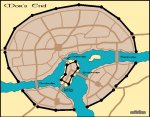
That's exactly why we changed the Eastern trade route to be South of the river: The main trade route comes from Kul Moren and parts West of Lalaton (not drawn in yet, but probably should be), enters the city at Westgate, crosses the river at the Citadel or Newbridge, exits from the Tradegate, and continues south of the river towards the East.

The road crossing the swamp is a minor road and highly dangerous. Most trade from that direction would probably come via boat across the lake. Likewise, most trade going Northeast is via river barges because of difficult terrain (we should probably make the river curve upwards a little more, and draw in some terrain around it). The road coming out of Eastgate is a minor road.
 
Last edited:

Remove ads

Top