Pixels/square of Battlemaps

But why the difference between 28-odd and the 37 Morrus suggested? I assume there's some compression in the image in the PDF?

Can you try the hedge maze map that Morrus posted in the preview thread and see if you get 37? I get 34.7

Yep, I got 34.7 on the hedge maze map from the preview, too.
 

log in or register to remove this ad

For comparison's sake, I tried the Coaltongue map from Page 14 (the 17th page of the PDF). It appears to be 21.97 pixels per square. I have no idea where the 31 is coming from; perhaps the Pathfinder version is totally different?
 

I'm going to download MapTool and do some testing with the original JPGs and let you all know what I find out. (I'm pretty sure the numbers in the OP are derived from those, and not the resized/resampled copies in the PDF.)

Is MapTool the only program I should be looking at, or is there another that I need to test?

In order to properly conduct my testing, I also need to know how you all are measuring the squares. See the attached graphic. Assume the black squares are the pixels in the dead center of the gridlines, and the grey squares are the antialiased borders of those lines. Are we using the red, green, blue, or purple count?
 

Attachments

  • Pixel Count Map.gif
    Pixel Count Map.gif
    7.8 KB · Views: 102
Last edited:


I'm going to use the images Ryan sent me during layout, since those are the ones I'd be passing along in a theoretical ZIP file to accompany each future adventure.

Now it's possible I'm barking up the wrong tree, but I envision a shorter workflow than the one in your blog there. In particular, I want anyone using Paint.NET or the GIMP to be able to just open a map JPG, use the measurement we provide, scale the JPG, and save and close it, and only then get started with MapTool.
 

That would be grand.

Ultimately, maptool is only the endpoint. All the work involved is to get the image to 50 pixels per square. Once you've done that, you just import the image into maptool and move the grid around until it sits neatly on the image's map lines.

PS. I'm using the blue measurements too.
 
Last edited:

Yes, exactly. If you do the work for us by either already doing the math (maps are currently at 28.24 pixels per square) or resizing them to 50 pixels per square, great! The workflow I use is only because, well, I don't know of a better way.

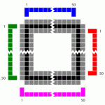
Measuring a single square is not accurate enough, just to be clear. If you have an image that starts off at 2200 pixels wide and you say it's 31 pixels per square, then the final map could be anywhere between 3498 and 3601 pixels wide. It makes a big difference. If the rescaled map is "close, but not quite there" then the tokens in MapTool will line up with the map wherever you match the image to the grid (say, in the middle) but will get progressively farther and farther off as you move away from the matched area.

Edit: Also, I realize that I may have confused you based on my workflow on the blog; sorry about that. That workflow is specifically for rescaling a map image I CREATED in MapTool. The only thing I'm using MapTool for there is for counting squares (because that's a drag to do manually).

For an image like the ZEITGEIST maps, I only use Paint.NET. Open the map, zoom way in, count the number of pixels from the first square to the last square, count the number of squares, do the math, rescale, done. At that point, I can import the map to MapTool and use it.
 
Last edited:

So far I am finding that taking measurements is much easier in the GIMP (GIMP - The GNU Image Manipulation Program) than it is in Paint.NET. I add a layer, count off about 30 squares so I have a good "sample size" (I use the paintbrush on the new layer to "dot" the squares I've counted -- a new layer so I don't accidentally mark the map itself), loop the squares with the rectangular selection tool, then zoom in to finesse the selection.

I haven't discovered a way to do this in Paint.NET. It's possible in the GIMP (and Photoshop of course) because you have the ability to directly adjust the selection rectangle after you've drawn it (by simply grabbing a corner or side and dragging), which makes the "loop-zoom-adjust" technique feasible in the first place. Of course the GIMP is a Java application, and Paint.NET is a native Windows application, etc. etc.

I certainly think the "blue measure" is the way to go. And my measurements of the "original" Coaltongue map (not extracted from the PDF) match the 28.8ish measures, so I think I'm doing it right. :) (I also got the "squares weren't square" result.)

Finally, I've had a look at my rescaled version in MapTool (I also needed more than one attempt) and it seems to be OK -- one or two pixels off at the extreme end (which I finally solved with a quick "touch-up" resizing in the GIMP). So when I get some time, I'll use this procedure to re-measure the maps from the "preview" thread and post my results (remembering to double-check for non-square squares in the unlikely event that happened to another map). But if you don't want to wait for me, I can recommend using the GIMP to take the measurements (and doing the rescaling).


Remove ads

Top