• The VOIDRUNNER'S CODEX is LIVE! Explore new worlds, fight oppressive empires, fend off fearsome aliens, and wield deadly psionics with this comprehensive boxed set expansion for 5E and A5E!

die_kluge's story hour - The Lost Continent

der_kluge

Adventurer
Game #1 (Saturday, October 4th) (cont).

The crew stared head-long into a dreary 4-month journey at sea. Valgo wasted no time attempting to introduce the adventurers to the crew members. "We've got 4 months at sea with these folks, Valgo, I imagine we'll learn all their names by then", they joked.

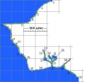
Shortly after their departure, Valgo eagerly called the party inside his quarters. "I wanted to share with you some of the inside information about where it is we're going." Valgo, sitting down with journals, and maps, and blank graph paper on his table, invited them to sit down. "Before Gorian Landiler's expedition landed on Terra Clanculum, another explorer - Alexander Richtus first discovered the continent." "Yes, we have heard the tales", Rath mentioned. "Yes, it was a very big discovery", Valgo continued, "Alexander set out to the east not knowing what he would find, but he discovered the coast of a large, undiscovered continent. He knew that he was ill-equipped to initiate a landing and an inland investigation, so he chose - wisely in my opinion, to map out a large chunk of the coast. Alexander had a cleric aboard that was able to make food, so despite his crews' eventual disgust at being at sea for so long, he was able to map out what we believe to be the entire western shoreline of this continent. He returned to the Bastion and was lauded as a hero - and rightly so. This map, along with his obnoxiously detailed journal entries proved an invaluable starting point for Gorian to launch his expedition. It is with these same maps and journal that I intend to follow in Gorian's footsteps." "It is our intention to find out what happened to Gorian", Nytor asked. "No", Valgo replied, "Not really. We intend to drop anchor where Gorian intended to drop anchor because there is evidence of an ancient civilization there. If we are able to find Gorian and his crew, that would be an added bonus, but it is not the intention of our mission." "And what exactly is the intention of our mission", Bax asked, as if already knowing the answer. "To simply seek out new civilizations, and recover any lost artifacts that may add to our knowledge of our past. As you are aware, as a stipulation of your contract, any items that we find as a part of our explorations are yours to keep for your services, but items that hold significant archaeological, or educational value will be kept by the archaeologist's guild. This is, of course, a standard practice. But enough about that, allow me to show you the map that Alexander made. It is quite impressive and detailed.", Valgo said, redirecting everyone's attention to a map in the center of his table.
 
Last edited:

log in or register to remove this ad

der_kluge

Adventurer
Handout #1 - the Coastline map
 

Attachments

  • Valgo's map.jpg
    Valgo's map.jpg
    19 KB · Views: 408

der_kluge

Adventurer
Handout #2 ( in several parts)

Alexander Richtus' Journal

Valgo reads from the journal...

"The journal itself was massive, and contained detailed day-to-day activities aboard Richtus' vessel. Most of it is fairly boring. I have boiled down the relevant bits into a smaller form. Each numbered area of the journal corresponds to the numbers on his map."


Alexander Richtus’ journal

1 – After spotting the continent, we sailed to its northern-most point. This point is the immediate-most northern point of the continent. From here, it journeyed further south as far as we are able to see. We sailed another day south here, and it showed no sign of turning back. From here, we sail back west, and will map the western side of Terra Clanculum.

2 – By remaining a fair distance off shore, we can take in the scope of the land. It is a beautiful country, with lush vegetation, mountains and valleys, and streams. This location has seen a constant panorama of forests and jungles. The land here is fairly flat, and white, sandy beaches dot the shoreline every mile or so.

3 – We saw a large herd of deer that had apparently been spooked by something inland, as they all came running out of the woods, and then down the beach. My crow’s nest crew spotted them early in the morning.

4 - There isn’t much geographically new here than from areas 2 or 3. There was a rather sizable beach some 2 miles long or so. From there, it sloped gently up into a rolling valley that stretched on for some time, into some dense forests.

5 – The jungles here come all the way up to the shoreline. Trees some 80 to 100-ft. tall dot the landscape. The land here is thick with overgrowth and dark to the core. Along the shoreline, large rocks, and rock formations dot the coastline.

6 – We dubbed this point Cape Richtus. It is a prominent mountain range that juts into the sea. The mountains are nearly vertical and extend well into an impressive mountain range that goes well into the mainland. The tops are dotted with trees, but are mostly rocky - all in all, a very impressive sight.

7 – This terrain is rockier, and more mountainous. The mountains that extend out into Cape Richtus extend even to here, making this an impressive mountain range indeed. From a distance, we spotted some mountain goats grazing on the cliff faces. The mountains do not end abruptly like they do in Cape Richtus, but rather start at the shore and work their way up into tall mountains.

8 – A mountain range, perhaps a new mountain range, or an extension of the same mountains we’ve been seeing for the past several weeks comes into full view here. It is several thousand feet tall, and extends nearly to the shore. Between this area and area 7, the terrain was rocky, but still quite forested. We’re not sure, but it may be that the tops of these mountains are actually snow-capped.

The wizard grabbed this picture of a small island just off the coastline.
 

der_kluge

Adventurer
(having a dickens of a time getting the image upload stuff to work today....)
 

Attachments

  • journal picture 1.jpg
    journal picture 1.jpg
    8.3 KB · Views: 392

der_kluge

Adventurer
9 – My crow’s nest spots a strange construction just off the shore. A stone pyramid set amongst the dense vegetation. Though it is covered in vines, and apparently hasn’t seen use in a long time (probably a pre-Ice Age structure) it is obvious to be man-made, and not a natural occurring phenomenon. We do not observe any other structures like it, or other man-made structures in the surrounding areas, however. It appears to be alone in this regard.

10 – Sloping up from the shore, we can just make out another huge mountain range in the distance here. Again, whether these mountains are attached to the previous mountain ranges we’ve observed, we are unable to determine.

11 – A large sandy beach was observed here. Crabs were seen along the shore. Since we’d reached the halfway point on our rations, I authorized a small vessel to procure a large supply of these crabs. The cleric on board assures that we have plenty of food and water, but that stuff gets so old after a while. We ate well that night. It really helped boost morale on the ship since we’d all been kind of bored mapping for so long.


My wizard captures this picture just after sunrise. Another small island just offshore. Note the mountain ranges in the distance.
 

Attachments

  • journal picture 2.jpg
    journal picture 2.jpg
    16.3 KB · Views: 363

der_kluge

Adventurer
12 – Some more mountains were spotted. We’d been seeing an increase in rocky formations, and had started seeing mountains in the distance over the last several days. There is nothing more of interest here.

13 – This seems to be the southwestern corner of the continent. From here, it continues eastward. The land here is decidedly flat, but yet still overgrown with thick vegetation, and tall jungle trees.

A clear view of the mountains near the shoreline.

(ed note: ignore the anachronisms in the picture)
 

Attachments

  • journal picture 3.jpg
    journal picture 3.jpg
    13 KB · Views: 372

der_kluge

Adventurer
13 – This seems to be the southwestern corner of the continent. From here, it continues eastward. The land here is decidedly flat, but yet still overgrown with thick vegetation, and tall jungle trees.

14 – Small sandy shores dot the beaches, but otherwise it is nearly identical to area 13. The land here is slowly curving northward.

15 – At this location, we observe a major tributary. Here there is a large river that flows from the inland. We have decided to pursue this waterway inland to see where it leads. Traveling this should not prove to be very difficult, as it is several miles wide.

16 – The river forks here. We have not observed anything highly unusual about the river or its surroundings. It very much appears to be similar to the oceanfront. There are dense forests all along the river here, and the occasional beach. We did observe some unusual stones that were on one such beach. Though there was much debate and speculation by all, we felt that they weren’t quite indigenous to the native rock, and some appeared to have a man-made touch to them. For instance, some appeared to be more rounded than what a naturally occurring rock should look like. We all agreed that if they were man-made, whatever structure they were a part of is long since gone, or at least possibly within the dark confines of the forests near here.
We have decided to take the left fork. The clerical divinations did not indicate woe with either path, so a coin flip has decided our fate.

17 – This path has taken us into a huge lake, stretching for several miles. Indeed it has taken us several days just to map the extent of its size. From here, the river continues northward.

18 – The river forks here yet again. It has become increasingly narrower over the course of the past few days. We have decided to forge up the left fork, since that has proven successful thus far. Eventually, we decided to turn around, since we don’t want to risk running aground. The area here is choked with vegetation, and practically envelops the river at times with overhanging branches from tall jungle trees.

19 – Heading back up to the fork, we proceed up the right fork, and encounter much of the same terrain as the left fork presented. The lush vegetation of this valley makes mapping anything but the immediate surroundings all but impossible. A few flying spells here and there from our wizard, and we are able to see (once we surpass the trees) that this is indeed an enormous valley that stretches on for miles in every direction. Eventually, we are forced to turn around.

20 – Proceeding all the way back to the original fork, we find another huge lake inland. Following the left-most shoreline (left has been fairly good to us so far), we map a large island, with a large rocky beach on its northern shore. The cleric, wizard and I were discussing the land, and we all agreed that it was unusual that we hadn’t encountered any sizable living creatures at all. We had been seeing birds of all colors amidst the trees, and at night it is a glorious sound of birds and insects, and bats were known to swarm around our crow’s nest. The crew had even caught several fish in their nets in the lakes here. However, nothing of intelligence had yet been spotted. If there are civilizations here, they are surely all nestled deep inland, as we’ve not seen any real indication of any yet.

21 – This enormous lake is easily twice the size of the lake in area 17. In fact, if the water wasn’t fresh water, we’d have all swore that we had come back into the ocean, since it stretches all the way to the horizon. There is another river that pours into this body of water that connects to the northeast corner. The entrance is rocky, and we decide it best not to risk it.

22 – Only after circling back southward from the lake area 21, do we realize that we’d mapped the western side of an island. The island itself is ordinary, and covered in the same dense vegetation that the surrounding countryside is covered with. On this date, however, we spotted some spotted leopards near the shore, drinking from the lake. We observe them through the spyglasses. And they were only visible for a short period of time.

23 – Having made our way out of the river system that started at area 15, we have come back into the ocean, and are continuing down the shore eastward. The crew is all very tired, and the natural rations were all gone weeks ago. The cleric even commented to me that he was sick of asking his god for the same food-making spell over and over again. The crew knows that this work is important, and indeed the information that we have gleaned is invaluable. We eventually make our way here to another river, and decided to forge inward.

24 – Traveling up the river for a solid week, it eventually turns very mountainous, and the river cuts a fjord through some mountain formations. After some time, we are traveling at the base a huge crevasse and the light from the sun is only visible to us for maybe 2-3 hours at a time before going back behind the mountain wall. Eventually this path becomes fairly narrow, and we decide to turn around. It was a sight to behold, nonetheless.
 

Attachments

  • journal picture 4.jpg
    journal picture 4.jpg
    24.6 KB · Views: 382

der_kluge

Adventurer
25 – Here we spotted some wild horses grazing in a field. The area was large and flat, and filled with knee-high grasses as far as the eye could see. The shoreline is rocky, but spotted with sandy beaches here and there. My crew is anxious to leave, and I have assured them that we will do so shortly. I am as anxious to get back home as they are.

26 – Here, the continent begins curving northward, and we have decided to finish our expedition on this, the point that seems to be the southernmost point of the continent. It seems a fitting end to a long and difficult journey. The area here is considerably more rocky than area 25, but is essentially as flat, and covered in thick, tall trees.
 

Attachments

  • journal picture 5.jpg
    journal picture 5.jpg
    10.1 KB · Views: 376


Breakstone

First Post
I love it, die_kluge!

Where did you get those pictures?

I've always wanted to DM an "exploration" campaign myself, so this'll be fun to read.
 

Voidrunner's Codex

Remove ads

Top