EN World City Project: Geography

Conaill

First Post
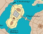
Skenfrith is way too small for what we have, but it's essentially the same idea as my earlier sketch: a ringwall around the island, and a solid central keep inside it.

Beaumaris looks cool, but it looks like it was all pretty much designed by one architect and built all at once (which, I believe is the case for many of the British castles: Britain went through a huge expansion in number and size of castles during a relatively short period of its history). I would prefer something a lot more "organic", like some of the mainland european castles.

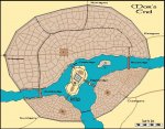
Here's the Counts' Castle (Gravensteen) from my own hometown of Ghent:
sgr1.jpg

grstn.jpg

You can get a nice virtual walk-through of the castle (click on the "EN" button for English).

Edit: hmm... seems like the walkthrough doesn't work too well in the English version. You may need to pick the NL or FR version to get all of it...
 
Last edited:

log in or register to remove this ad

Conaill

First Post
Regarding the latest sketch of the Citadel: we do need to draw in the trade route connecting both bridges, which should *not* go through the inner set of walls. Then you also need space for entire trade caravans to gather (the toll collectors would presumably want to check the entire caravan before asessing the toll and letting the caravan pass).

Add in the fact that you don't need such an immense inner courtyard (600 feet... what, are you planning on playing football there? ;)) and you get something that's probably more like halfway between out two designs.

PS: we really need to draw in the actual keep as well, i.e. the solid central building that houses everything that all those walls are protecting. In my sketch I had intended the entire inner circle to be the keep, but now I do think that we need an inner courtyard as well, separate from the outer more "public" area where the caravans gather.
 

Conaill

First Post
Been reading through the Castles of Britain site Knightfall posted earlier. Very informative, but keep in mind that the four castles featured there aren't very representative of the possible variety of castles. Three of the four (Beaumaris, Harlech and Conwy) were built pretty much from scratch by Edward I between 1277 and 1283. That's why they share so many features (especially the very "planned" and symmetrical look, and the huge round towers).

I'll see if I can dig up some more pictures...
 

Knightfall

World of Kulan DM
Last Citadel revision for a while

Ok, this work on the citadel is taking up too much of my time. Thus, I won't be revising this for a while. There are other things I have to do for the city map, as well as my own mapping projects.

I tried using curved lines for the curtain wall but it looked awful. Very unnatural. The main keep in the center is finished. I'm going to keep it simple.

Next up is a curtain wall for the older part of Mor's End. This will include all of the merchantile district on the northern shore. (I dont think the Posh District will be included in it. It would look weird.)

Later,

KF72
 

Attachments

  • citadel_new_ver2.jpg
    citadel_new_ver2.jpg
    78.8 KB · Views: 222

Conaill

First Post
Looks good for now. I agree there's more important things to work on for now. I still like the idea of having the original toll gate in between the bridges. Perhaps the gate is freestanding in the center of the area north of the keep, kinda like the Arc de Triomphe?

I wouldn't add too many extra walls in the city. I don't think 300 years is long enough to develop a second ringwall, and we don't have enough guards to man the wall as it is.

Here's one idea that needs urgent implementation: put a grid on the map! You know... A-Z across the top, 1-10 down the side. Make the grid as fine as possible,maybe adding AA-ZZ etc. as well. That way, posters in the Crafts and NPC threads can start specifying exactly where they want to place certain buildings.
 

Knightfall

World of Kulan DM
Revised Main Map

Ok, this is where I am. To sore to type. Will show closeups tomorrow.
 

Attachments

  • mors_end.jpg
    mors_end.jpg
    108.3 KB · Views: 208


Knightfall

World of Kulan DM
CLOSEUP: Ruined Inner Wall

Ok, this wall was originally built to protect the city when it was much smaller. It evolved from being a simple wooden wall to a stone construct. This wall took a pounding in its day and the last time it was breached the city didn't have the resouces to rebuild it.

Plus, as the city continued to expand and the main outer wall was built, it became less vital to defense. The city's limited monatary resources were allocated to other thing and the wall was never fixed.

Certain sections are near collapse, especially in the northeastern part of the city. Some of the sturdier walls and towers have been bought and used by private owners, strong foundations for their homes and businesses.

However, the one tower near the Dwarven District and last two towers in the ruined chain near Newbridge are still under the control of the city and are used by the watch.
 

Attachments

  • ruined-wall.jpg
    ruined-wall.jpg
    56.4 KB · Views: 174

Knightfall

World of Kulan DM
CLOSEUP: Posh District

Unlike the portion of the wall that was left ruined in the eastern half of the city, the Old Wall, as it's called, was rebuilt shortly after the attack that destroyed it. Not rebuilt by the city, but by the private coffers of the city's nobility, this wall is still sturdy, and is often manned by the private guards of those same nobles.

However, in a time of crisis, any high ranking city official, military or otherwise, can take command of this wall to help defend the city from attack. Not even the nobles would dare oppose Lady Kelvin or the Castellan during such a crisis.

While the Old Wall refers to the entire wall that stretches from Wallbridge to the edge of the Dwarven District, it is this section which is well maintained, as it divides the Posh District from the rest of the city.

The city's nobility wish to have a another wall built stretching from Westgate to the Old Wall on the northern side of Traders' Way but so far, the Castellan has refused their request. Such a wall serves no real military purpose and would further divide the city.

Note: The Downpour Alehouse would be located on the other side of the Old Wall, just beyond the edge of the map.
 

Attachments

  • posh-district.jpg
    posh-district.jpg
    54.2 KB · Views: 172
Last edited:

Knightfall

World of Kulan DM
CLOSEUP: Dwarven District

Ok, here's the dwarven district, this time with it's gates included and a semi-finalized road layout. (All of these road layouts are semi-finalized, BTW.)

The inner wall here wasn't goingto be rebuilt after the attack that destroyed the Old Wall but the dwarves living in the district couldn't stand to look at the crumbling fortifications. The entire district purchased the wall from where it turns south towards the western part of the city to the tower just before the watch tower on the other side of the Northern Way.

The dwarves rebuilt the wall and added to it as well, stretching the wall all the way to the western tower of Northgate and up to the city's outer wall at the western end of the district.

The dwarves scoff at the notion that the Old Wall is is better condition than the Dwarven Wall. And one could say that it is just as solid as rebuilt section of the Old Wall near the Posh District. In reality, it's like comparing apples and oranges.

Both are just as sturdy, but the Old Wall was built by humans. The Old Wall is simple and strong while the Dwarven Wall has been built by dwarves for dwarves. The wall would last a thousand years without maintenance and is carved like a dwarven work of art.
 

Attachments

  • dwarven-district.jpg
    dwarven-district.jpg
    54 KB · Views: 171

Remove ads

Top