How do you create setting maps if you can't draw?

I've done the same as Hejdon...use google maps or google earth to find a coast line or island I like. Then I copy that into the Gimp or paint.net, trace the outline, and color or adjust it until I like it. It's taken a while to get good at it, but I'm really starting to like my results.

Attached are two examples. The Greentarn map is actually the northern island of the Philippines, shifted and cropped a bit. Regalport is where Manila is in the real world.

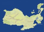
The Kingsholm map is Vanuatu off the east coast of Australia.
 

Attachments

  • greentarn.relief.jpg
    greentarn.relief.jpg
    74.9 KB · Views: 108
  • Kingsholm.jpg
    Kingsholm.jpg
    48.5 KB · Views: 387

log in or register to remove this ad

Because I'm OCD about certain things, I just broke down and set my campaign in the real world, map and geography wise. My current campaign is happening in the area of West Virginia and Maryland, up into Pennsylvania. New York State has a major blasted zone across most of it. I find it works really well, because I can refer to climate, weather, geological, and other resources from earth and be certain they're at least close to accurate. It gives real depth to the world's underpinnings.
 

Gilladian said:
Because I'm OCD about certain things, I just broke down and set my campaign in the real world, map and geography wise. My current campaign is happening in the area of West Virginia and Maryland, up into Pennsylvania. New York State has a major blasted zone across most of it. I find it works really well, because I can refer to climate, weather, geological, and other resources from earth and be certain they're at least close to accurate. It gives real depth to the world's underpinnings.

You're in good company, considering that the Gygax's actual original Greyhawk campaign also used the map of North America. The city of Greyhawk was in the place of Chicago, and the Great Kingdom was New York. The Nyr Dyv was originally Lake Superior.
 

Remove ads

Top