
Kid Charlemagne
I am the Very Model of a Modern Moderator
My suggestion is to look at maps, lots of them, and try to draw your maps following the visual cues you'll pick up.
Here's a site that could be useful. You can switch from geographic maps to political maps of the exact same area easily, and zoom in and out as needed to get a good look at various areas.
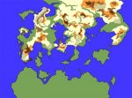
My own plan of attack when making up a new large scale map is to base it off of real geographic formations, but change it enough so its not obvious where it came from. Here's an example of my latest (only partially finished) map that I've been working on:
Here's a site that could be useful. You can switch from geographic maps to political maps of the exact same area easily, and zoom in and out as needed to get a good look at various areas.
My own plan of attack when making up a new large scale map is to base it off of real geographic formations, but change it enough so its not obvious where it came from. Here's an example of my latest (only partially finished) map that I've been working on:
Attachments
Last edited:


