Priest_Sidran said:
That is what my real problem is is that I can't seem to figure out how to add wording to a map in a way that I want. (Is there a program that lets you put text on a path).
Jurgen, I have Paint Shop Pro for the layered stuff and I have problems with that. My magic wand no longer works so very magically.
yes, there is a way to do text using this technique. all you have to do is look for a command called "fit text to path" or something. i'm not sure if you can do it in ms paint, i've only worked with it once or twice and was really dissapointed. I switched to corel draw and now i'm loving it. take a look at my thread for examples.
about the text thing, if you can't find it, look in the help menu index or search function. i'm sure you'll find a way to do it.
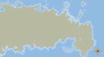
by the way. your maps look good. if i could give you one piece of advice, the first one is good for a player map, only the text is hard to read. i'm sure yours is okay, and this is a low quality jpeg, but it seems a little washed out for me. good job on the mountains.
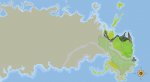
the second one is good, but i would perhaps change the boundary lines. on a real map, boundary lines are mostly squigly lines that follow the contours of the natural features of the world. such as rivers, mountains, and other bodies of water or topographical areas. if you look at geological surveys and property deeds you will find that ancient peoples and pre technology had boundary lines listed as, "Following the flow of river Putane until the fortieth league from the city of Harvenfarven" or something like that. most of the time, you didn't even know where the boundaries were, as the frontiers of a country changed from day to day. take a look at the old greyhawk maps from the 1st ed game, or even the latest new ones. you won't find any boundary markers there.
all in all though, you are doing great. i wouldn't mind seeing what the latest one looks like. keep it up!
")