You are using an out of date browser. It may not display this or other websites correctly.
You should upgrade or use an alternative browser.
You should upgrade or use an alternative browser.
Photoshop'd maps, etc.
- Thread starter Kid Charlemagne
- Start date
Kid Charlemagne
I am the Very Model of a Modern Moderator
kkoie said:I don't know why, but I never thought of using photoshop to do maps, thats a great idea.
K Koie
Ever since I upgraded to 5.5 (now 6.0) and learned how to make good use of layers, I've been hooked. I made some early ones with Paint (years ago) now I'm pretty much just using Photoshop.
Kid Charlemagne
I am the Very Model of a Modern Moderator
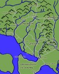
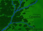
Here's a map of an area north of that indicated on the previous map. This one was designed to be more of a player map, and so has a few more "artistic" touches. I'm pleased with how the trees came out - I'd tried dozens of ways to represent forests, and finally figured out what to do...
Attachments
Kid Charlemagne
I am the Very Model of a Modern Moderator
Nareau
Explorer
Cool maps...
You might consider saving them as .gif's instead of .jpg's. The way .gif does its compression, you'll likely get better quality, smaller files. Gif does well with large areas of single-color, and is best for line drawings and the like. Jpg does well with gradients, and is better for photographs and other images that require more subtle changes than sharp definition.
You might consider saving them as .gif's instead of .jpg's. The way .gif does its compression, you'll likely get better quality, smaller files. Gif does well with large areas of single-color, and is best for line drawings and the like. Jpg does well with gradients, and is better for photographs and other images that require more subtle changes than sharp definition.
Kid Charlemagne,
How did you do the trees and how do you do mountains? I have been trying forever to get something I like, mainly for the mountains, but good trees would be cool to.
I have one map I did a major update/cleanup to for a friend in PS. Someone else from the group had drawn it for him before I started gaming with the group. It was done on a 20-30 poster board material with some kind of colored pens. IT was beat up and had a few stains, plus the DM trying to add cities with horrible handwriting.
I had to scan it, in 4 seperate pieces and put it back together. Then I cleaned up all the color and edges. Then I put it in Pagmaker to do all the text work. I was working at Kinko's at the time so Iprinted it on a large format color printer and laminated it.
It turned out really good, and I haven't been able to get anything even half as good since. :-(
JDragon
Kid Charlemagne
I am the Very Model of a Modern Moderator
JDragon said:Kid Charlemagne,
How did you do the trees and how do you do mountains? I have been trying forever to get something I like, mainly for the mountains, but good trees would be cool to.
JDragon
All I really did was draw one (by hand) in a seperate layer, then copy it, crop it, and paste it into its own file. Then, I cut-n-paste that image into subsequent maps.
For the trees, I made several files, one with a single tree, and a couple with varying numbers of trees (groves, if you will) so I could paste a larger section into a picture (pasting hundreds of trees into a picture one-by-one gets REAL old REAL fast).
For the mountains, I did more or less the same thing, except I drew several different mountains, and pasted them into the map. There are 5 or 6 different mountain shapes, and using them sparingly keeps you from noticing that some of them are identical.
EDIT: looking back at the first image in the thread, it looks like I might have drawn all of the mountains by hand... I can't remember. I think that they are based off several "basic" Mountain shapes, and then I added little flourishes to individualize them.
I was trying to achieve a look similar to the maps in the front of the LoTR books, and other similar books, as well as similar to D&D maps...
The most important thing for me is to be able to make them look good, but also to make doing the pictures fast and easy. I'm not one to slave over an image for days. If I'm not making fast progress, I set it aside and wait for inspiration to strike, because I know that when I get inspired, I can churn out an image in no time at all.
Last edited:
Kid Charlemagne
I am the Very Model of a Modern Moderator
Darraketh
First Post
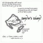
Great maps! I like Sander's Island the best, it says ADVENTURE!
I think PaintShop has something called Tubes where you can add cloned images by dragging the mouse. Photoshop may have somethin comparable.
Kid Charlemagne said:
All I really did was draw one (by hand) in a seperate layer, then copy it, crop it, and paste it into its own file. Then, I cut-n-paste that image into subsequent maps.
For the trees, I made several files, one with a single tree, and a couple with varying numbers of trees (groves, if you will) so I could paste a larger section into a picture (pasting hundreds of trees into a picture one-by-one gets REAL old REAL fast).
For the mountains, I did more or less the same thing, except I drew several different mountains, and pasted them into the map. There are 5 or 6 different mountain shapes, and using them sparingly keeps you from noticing that some of them are identical.
I think PaintShop has something called Tubes where you can add cloned images by dragging the mouse. Photoshop may have somethin comparable.
Similar Threads
- Replies
- 95
- Views
- 8K
- Replies
- 68
- Views
- 5K
- Replies
- 336
- Views
- 22K
Enchanted Trinkets Complete
Recent & Upcoming Releases
-
December 9 2025 -
June 18 2026 -
October 1 2026


