sandbox campaign - map size/scale?

If I'll create my campaign in a wide cluster of islands, I'll probably use 30 miles per hex for the big overview map, and 6 miles per hex for the higher-res individual island maps. The idea is to have the northernmost islands frozen year-long, while the southern islands would have a more temperate climate in the spring and the summer, so there should be some serious distance (unless the southern islands would be warmed by an ocean current coming from the south).

The intention is to allow "island hopping" with a small coastal ship or sailing boat, while leaving the sandbox to the open ocean would require, for the very least, an expensive longship and a trained crew, and even then would be quite risky; for really going deep into the open ocean, a carrack or caravel would be needed. All of these options, as well as magical transportation, are expensive and thus limited mostly to the higher levels.
 
Last edited:

log in or register to remove this ad

I'm really starting to like that big map/small maps split ideas. This way I can have both medium-distance water travel and shorter-distance (and more detailed) land exploration in the same campaign.

I'm thinking about 6 miles per hex for the high-res, small-scale focused maps. So what would be a good hex scale for the low-res big overview map? 18 miles per hex? 24? 30?
 

Regarding the OP, a good suggestion I've heared for larger-scale maps is having one hex per distance covered by a day of foot travel in good conditions (24 miles in 3E, 18 miles in BFRPG). A good 30x30 hex map could give you a 724x724 mile map (3E) or a 540x540 mile map (BFRPG).
 

Well, I use 50 miles/hex for my continental map of my Ea/Lands of the Old Empire setting, then 10 miles/hex for the next level down. 30 and 6 should also work well, but I find 50 mile hexes are ideal for grand tactical stuff like monthly troop movements.
 

This will be long. I don't want it to be long, but I know up front I'm going to give you a brain dump from my current sandbox campaign. So, apologies. Or "you're welcome" if you're into this sort of thing.

I'm not going to map out the whole world but is there a good rule of thumb for sizing the campaign area?
I'm of the opinion that you should indeed map out the whole world, so that you know when to say to your players, "there isn't any more land." Of course, eventually they'll be off in spaceships or spelljammers or something and it won't matter, but for the first huge chunk of the game, it matters a lot.

The good news is that this very big map can be very sloppy. I can do a basic one in 5 minutes. Just landforms will do it. However, if you're feeling inspired (and you have the ability to reign yourself in before becoming overwhelmed), then getting general notes about each region is cool. For example, knowing that the eastern portion of the map is frozen tundra populated by frost giants is very useful. You don't need to stat up any creatures or even pick the areas of civilization (though you could), but it's always nice to give yourself a framework that will help you to wing it convincingly when the players suddenly go hundreds of miles off course on a whim (which they do).

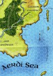
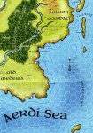
Having said that, in my campaign, I use the giant Greyhawk poster map as my world map, but in terms of what the players do on a day-to-day basis, I focus on the region around Rel Astra. Here I'll attach a tiny little portion of the big map, which I scanned in and used from levels 1 through 6:

attachment.php


Some things to note about the map. First, it's a modified scan -- the Hightower Tor, Zolmik's Retreat, Almack, Seawell, and the lighthouse were all added in with the Gimp (a Photoshop-like tool). The areas south of Rel Astra would have been very unpopulated otherwise.

The second thing to note is that the hexes are huge -- 30 miles each. I handwave them to be even slightly bigger -- 32 miles each. That's because in D&D 3.5 (which I use), 32 miles is the normal daily movement speed for people on horses. So it's easy to say "1 hex per day."

Third, I like that things are so far apart. I really don't like 4th edition much, but the "points of light" idea was a prizewinner for me. I want my game world's towns to feel like isolated little points of civilization, fighting back the monster hordes. So going from Rel Astra to Almack is about a 3 day ride, and I want that ride to be scary -- maybe not lots of wandering monsters (it gets boring) but 1 big problem? You bet.

(That's what the "Hightower Tor" was -- that's the free 1st-level module on the Wizard's site that has a zombie hobgoblin to fight. Well, after my players cleared it, I had the local hobgoblin tribe assume that their burial grounds were deliberately desecrated by Rel Astra. While the PCs gained levels 2 & 3, I had the tribe gathering there, rebuilding, and readying to launch a war which the PCs could have stumbled upon and stopped. However, around level 4 they began moving by boat, missed it entirely, and so eventually I launched the war without them, resolved it, and just had it be a news/gossip item that they could hear about. That's the sandbox for ya.)

OK, well, I still have tons to add and this is already far too long. I'll start a second post. More maps. Hang on.
 

Attachments

  • rel_astra.jpg
    rel_astra.jpg
    345.4 KB · Views: 1,259
Last edited:

...Continued from above...

The second question is how detailed the scale should be. Should each hex represent 1 mile, 5 miles, 10 miles?
So I already showed you my main map for the game. Now I'll show you three variations I used, which address your question. First is simply the same map but with a few new areas (Foretown to the north of Rel Astra, plus the druids & temple as listed in the legend on the right), used by the players at levels 7 & 8:

attachment.php


The point is that you can see how I'm fleshing it out as they play. I do not need to obsessively map out everything before the campaign even starts. In fact, if you look closely at the forest near Rel Astra & the druids, you'll note that the forest has actually been redrawn to be closer to Rel Astra (I just used the clone tool in the Gimp, which is why the forest seems to fit in so seamlessly). I am shameless about retconning things if it works for the plot. I wanted the druids within 15 miles of Rel Astra, so they were.

Next map shows a zoomed-in view of the coast from Seawell to the lighthouse -- that tiny little dot on the big map is this huge thing that they played on:

attachment.php


I made that map using the free AutoRealm (tutorials here). It only took about 30 minutes. The Pooters, Piranha, and Peccary are territories of monsters from the Tome of Horrors. This zoomed-in view was useful for about 3 game sessions. That's how long it took my players to solve the lighthouse module.

Finally, here is an even more zoomed in map. This was used for 2 game sessions, and is actually drawn on a battlemat. I had the players use 1 mini to represent the whole party. They could move 5 hexes per turn, which amounted to a half-mile. On the lower left is Foretown, almost off the edge of the photo. The short black marks are 1-mile markers. The green weedy stuff is the Lone Heath marshland. The top right corner is a pyramid & blob (a lake) from the Sunken Ziggurat module. Halfway down the right edge is a building (the Treasure of the Black Veils module).

attachment.php


Most of the marshland was covered with sheets of paper at the start of the game session. I revealed things only as they got near. I put that extra lake between the two modules just to throw them off. It isn't significant at all. It's just water.

So they moved around, found some stuff, and generally had fun. Once they actually stumbled into a module area, I had a 2nd battlemat with the module floorplan. At that point they all broke out their minis and we had at it. :)

(By the way, that pyramid in the top right corner is the module that has now turned into the apocalypse in my game.)

What is a realistic area of a creature's hunting territory?
How far away can the creature move and still get back to its lair for sleep? That's how far. In other words, not very far for most land-bound creatures. However, note that this assumes we're talking about creatures with a lair. A young bear leaving home can search hundreds of miles before finding a place to settle.

How far will a common folk's knowledge of the surrounding area be? Will they know about far-away places, ruins, rumors, etc?
If you're trying to base this off of our world hundreds/thousands of years ago, then the answer is that historically people didn't know much at all. There will be exceptions -- adventurers, sailors, cartographers, and the nobles who underwrite them -- but most normal folk will live their whole lives and die within a 15 mile area. Their knowledge of other things will be minimal. D&D 3.5 actually does an OK job here with mechanics to back that up. The knowledge skills (which would apply to what people know of the area) cannot be used untrained, or at least not well. The PHB says that without points in a knowledge skill, people cannot know more than common knowledge (DC 10 stuff -- the easy obvious things). Since most farmers will be investing skill points into Profession (farming) or the like, the odds that any would have enough points to know anything about outlying areas is pretty minuscule.

Anyway, I hope all this helped you to have an idea about how I run my sandbox. Maybe there is an idea or two that you can build upon? Have fun.
 

Attachments

  • rel_astra_rev1.jpg
    rel_astra_rev1.jpg
    399 KB · Views: 1,031
  • lighthouse_map.gif
    lighthouse_map.gif
    21.4 KB · Views: 999
  • ziggurat.jpg
    ziggurat.jpg
    212.2 KB · Views: 944
Last edited:

I stepped away from this thread for a few days and just took a look - wow! So much good stuff in here. When I have an hour or so, I'm going to start from the top again.

Or "you're welcome" if you're into this sort of thing.

Thanks boyd! I just skimmed your posts but that's some great stuff. Much appreciated.

Now I need to go block some time off on my calendar... :)
 

If I'll create my campaign in a wide cluster of islands, I'll probably use 30 miles per hex for the big overview map, and 6 miles per hex for the higher-res individual island maps.
That sounds reasonable. It's also a perfect match for Gary's advice. Gary describes a "referee's map" at 5 miles per hex scale that shows a starting village, the location of the nearby dungeon/ruin, and the wilderness area immediately surrounding these locations. He also mentions a "campaign map" with a 20 to 40 miles per hex scale (and specifically mentions a 30 mile hex campaign map in the 1e DMG section on PCs developing territory -- incidentally, a 20-30 mile radius is the standard area that a domain "civilizes").

Also in the 1e DMG (the section on adventures in the outdoors), Gary mentions that a campaign hex of 20-40 miles can be divided into smaller hexes for more detailed maps: 5 hexes across the middle or 5 hexes per hex face, as desired. Under that scheme, if your campaign map is at a 30 miles per hex scale, that means your more detailed "referee's map" of a specific area would be at 6 miles per hex. Just right, eh? :)

As a cherry on top, the outdoor movement rates given in the 1e DMG list normal movement afoot with a light burden as 30 miles per day.
 

30 and 6 works out pretty well in leagues, too, if you're using a 3 mile league. On the 6 mile hex map, each hex is two leagues (i.e. a two hour walk for normal terrain). On the 30 miles hex map, each hex is 10 leagues (10 hours walk for normal terrain).
 

I'm using BFRPG, in which a lightly armored human can cover 18 miles per 8-hour day of walking over good terrain; that'll mean three 6-mile hexes per day in the open, or less for more difficult terrain. I'm even thinking about making random encounters per hex instead of three times a day; the more distance you cover, the higher the chances are you'll run into something or someone.

The 30-mile hex would fit some of the boats from BFRPG in daily movement.
 

Remove ads

Top