• The VOIDRUNNER'S CODEX is coming! Explore new worlds, fight oppressive empires, fend off fearsome aliens, and wield deadly psionics with this comprehensive boxed set expansion for 5E and A5E!

Tool for mapping a city wanted

Hussar

Legend
We figured that it's lover than a modern big city, because of far less levels of the buildings. You also need room for the streets, maybe a park, market place, shops, a large palace and much more. Munich today has 4286 per sq km and a fair amount of sky scrapers. Therefore we just halved that for a wild guess that is accurate enough to stop the players arguing about it. And for my city I though about half-timbered houses which should no feature more than 3 levels in general.

I'll take a look at the City Designer and see if it works good enough to be worth it's price. I one tried Campaign Cartographer and it was a total button hell. You were unable to figure out how anything worked at all. And id didn't seem to support an evolutionary development like with layers and stuff. I was pretty disappointed for the "top notch tool".

Just to jump on the pile a bit here, something to remember about medieval cities is that you would generally have large numbers of people sharing a single room. Families would not have their own bedrooms unless they were very rich. You'd quite possibly have seven, eight people sharing a single bedroom that probably doubles as the living/dining room during the day.

I remember being shocked when I traveled to Angkor Wat and toured the Bayon - a city of almost a million people around 1100, one of the largest in the world at the time - and I could get around the ruins on foot. Sure, it took a couple of hours, but, you could walk across the city. When you don't need space for cars, streets become REALLY small.

Heck, ancient Rome wasn't exactly huge either IIRC.

I'd vote either Inkwell's city generator or the Cartographer's Guild. If you can't find a map that suits your purpose there, you're really picky.
 

log in or register to remove this ad


gamerprinter

Mapper/Publisher
I'm a senior member of the Cartographers Guild. Although Profantasy City Designer is a decent program for making cities, Profantasy software, being CAD is a pain in the ass, unless you're familiar with using it - there is a couple city designer tutorials at the CG however. And that random city generator is nice for creating realistic city layouts, but you have no control at using it.

Most of us mappers at the CG, rely on non-mapping specific graphics applications like Photoshop and GIMP or Illustrator and Inkscape to create our maps whether for a city or any kind of map. There are literally hundreds of tutorials at the CG for creating various kinds of maps using those kinds of applications.

Because those above mentioned apps are general graphics applications it means you have to design the city yourself without any software help, just use the software to create the buildings, roads, etc that you need for you map.

It could be helpful to use the random city generator to get some ideas on road layout, city walls and locations of specific things like parks, etc. Then go to GIMP/Photoshop or whatever your application of choice to emulate the generated city, but place buildings more specifically to where you want to place them.

This is how most of us 'pros' making city maps.

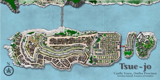
Here's a hand-drawn city map of Tsue-jo for my second and third adventure Curse of the Golden Spear for Kaidan. I finished the map with color and beveled shapes using Xara Xtreme, my preferred application of chioice...

tsue-jo-thumb.jpg


Link to larger version of this map... Tsue-jo castletown.

GP
 
Last edited:

Maggan

Writer for CY_BORG, Forbidden Lands and Dragonbane
City map tool

I use Adobe Illustrator for my iAltdorf project, but given that you are looking for a free or cheap tool, that won't fit the bill.

But if you find a free open source vector illustration program that is compatible with the Illustrator format, I can give you my file to work from.

I'm a lousy graphic designar myself but I have found that using a vector based program is golden, allowing for simple copying and alteration of basic shapes.

/M
 

gamerprinter

Mapper/Publisher
It may not appear so, but my city map above is completely finished in Xara Xtreme Pro 4 which is a vector application. I too prefer vector apps to image editors, however you can get some really fantastic designs from vector apps that don't look like vector maps, rather something created in Photoshop which is an image editor, not a vector app.

Many people using vector apps to create maps make overly simple, not 'graphic-y' designs, when vector apps are perfectly capable of creating those kinds of map. None of my maps look vector, yet all of them are created with a vector app.

Vector means fast, easy to alter, quick to render, and capable of exporting to any pixel dimension required. The above map design is a small thumbnail, but I am capable of exporting that as a 300 ppi, 24" x 48" map ready for hi-res printing, or can export to a pixel dimension useful for playing in a virtual terrain app, at 50 or 100 ppi.

Image editors force you to decide on pixel dimension at creation and you can't effectively resize without some graphic anamolies, like artifacts (extra pixels that create artificial and unwanted detail.)

I only use vector applications.

GP


Ebonyr

First Post
Looks cool. How long did it take? And did you create maps before often or is this one of your first ones?

It took me took me about 6 hours to get the map where I wanted it. I've been working on different map techniques for over a year. My blog has the progression.


Remove ads

Top