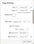
So, I did some quick poking and think I may have found your issue. In the map page settings, the very first set of things are the number of units for width and height and how many pixels that is. If you're doing default, then the number of pixels should be 70x the number of units. If you have a lesser number in there, then the image will not zoom in fully. This is because the number of pixels sets the image size at 100% zoom. If you've set it up for 30 units width at 70 pixels per unit, then at 100% it will be 2100 pixels wide. When you zoom to 250%, it'll be 840 pixels wide, still a reasonable viewing size. If, however, you've set it to be 30 units at 7 pixels per unit, then it's only 210 pixels wide at 100% and 8.4 pixels at 250%. The browser doesn't do that, so it limits the size of the image to something it understands better, so you get a postage stamp sized 100% and a small envelope sized zoomed image.
Check your pixels per unit and make the pixel width/height in the settings is large enough. It should be 70 pixels times the unit size of each to be the default.
Hope this helps and is actually your issue.
EDIT: sorry, this is what happens when you're typing from memory of a problem rather than refreshing it. The pixel per unit is fixed. But you can use very small unit/pixel sizes and it will cause the zoom problem. I used an image that is normally 36x24 (WxH) units, which translates to 2,420 x 1,680 pixels. I took the trailing zero off of the pixel counts for both width and height, and replicated your zoom issue. But, contrary to my above, this fixes the units to 3.6 x 2.4 units and doesn't change the pixels per unit. Mea culpa, should have refreshed my memory by looking before posting instead of a fuzzy memory from last night.