Discussion - LEW 4th Edition

Manzanita

First Post
There are disadvantages to using a map of our world as the basis for another. For one, the lack of mystery. Name confusion could be another.

We could assume that nothing has an official name until someone named it as part of the game. We could also allow modifications to the map, but only if the person who modified it provided an alternate map.

If we were to take this approach, I think the mediteranean would be a better starting point than the carribean.
 

log in or register to remove this ad

Wik

First Post
Mediterranean versus the caribbean, with new names?

It could work, although finding a place to throw a jungle might be a bit different. And I think it blocks the "island" isolation idea.

Personally, I like a Caribbean model, simply because it's much easier to allow GMs a bit of freedom in their game - a lot more flexibility.

Rystil: But with a caribbean model, we have several Continental areas - central america (Desert), north america (forests, mountains, and plains), Florida (great place for an empire), and South America (Jungle, Swamps). Plus, there are several islands in the chain (and we could add more) that are relatively large - Cuba is the PERFECT size for an island kingdom, and we could definately add a few.
 

Boddynock

First Post
Hmm, this thread slipped below my radar until now. I haven't read all the posts but re the latest discussions of real world geography, there is a dataset available that can be utilized by the Fractal Terrains software to produce a world map that we can then easily update in Campaign Cartographer.

I haven't yet got this combination to work but I am a very, VERY part-time cartographer, and I'm sure there are a lot of more skilled people here on the boards. The plus of it is that we can have accurate, realistic earth maps to which we can easily add our own labels.

It may end up being too much work but if we can do it I think it would be great! :cool:

'Nock
 

Wik

First Post
I think making a map shouldn't be all that difficult. I was thinking of picking up CC or Fractal Terrains, and this is just one more reason to do it. And I don't think we need much more than a "Very, very part-time cartographer" - once the initial mapwork is done, I think the amount of work required to update things will consist of maybe an hour every month or so, if that.
 

Rystil Arden

First Post
I don't think we should cleave so closely to a real-world geography. I mean, did you take a look at the Eyros map I linked? The guy who made that just sort of came up with it very quickly, and in my opinion at least, it's beautiful and very clear without being just a copy of a real-world map. I think we should invent cool stuff and then work out a map rather than use a real-world map and then be forced to place stuff based on that.
 

Wik

First Post
Oh, I fully agree that we shouldn't adhere to a real-world map. But I *do* believe we should look towards our world for inspiration. I say "Caribbean model" because I think that's an easy way to explain the rough idea of geography that I'd like to see.

But when it comes to making the actual map... I imagine it'll be quite a bit different. We could lengthen out some parts, and shrink others.

So long as we add in an island called "Wikia". :)
 

Rystil Arden

First Post
Wik said:
Oh, I fully agree that we shouldn't adhere to a real-world map. But I *do* believe we should look towards our world for inspiration. I say "Caribbean model" because I think that's an easy way to explain the rough idea of geography that I'd like to see.

But when it comes to making the actual map... I imagine it'll be quite a bit different. We could lengthen out some parts, and shrink others.

So long as we add in an island called "Wikia". :)
Well, if that's what you mean, I think our world should be bigger than the Caribbean--as I mentioned above, if we must use islands (I'm still not convinced we will be doing so, as it seems rather presumptuous to make such a commitment at this time without the support of the community based solely on the fact that we are a group comprised solely of earlybirds and people who dislike the fact that earlybirds can take over a process by virtue of nothing but the fact that they are earlybirds and thus joined to be a moderating influence specifically for that reason), it would be neater and require less weirdness (because let's face it--stretching the Caribbean to be a whole world in size is fairly unreasonable) to have several different areas that can be reached relatively quickly sometimes, despite their distance, due to the odd transitive nature of the ocean. I gave an example of four, but there could be more as well. The other good thing about this is that it draws a specific veil between certain sections and can help preserve flavour and cultural interests for players--particularly, if we started mainly in one or two areas, it would leave us room to expand.
 

Wik

First Post
Howzabout this:

1) We build around a "caribbean model".
2) We shrink South America, compressing it into a sub-continent of jungles and swamps.
3) We elongate western north america, so that it juts out further than usual.
4) At the end of that jutting point, we put another island chain (not as large as our carribbean chain)
5) and we add an island continent (england-sized) somewhere in the ocean, at least fifty miles from any other landmass.

Gives us a pretty large play area.
 

Rystil Arden

First Post
Wik said:
Howzabout this:

1) We build around a "caribbean model".
2) We shrink South America, compressing it into a sub-continent of jungles and swamps.
3) We elongate western north america, so that it juts out further than usual.
4) At the end of that jutting point, we put another island chain (not as large as our carribbean chain)
5) and we add an island continent (england-sized) somewhere in the ocean, at least fifty miles from any other landmass.

Gives us a pretty large play area.
I'm curious--what attracts you to the 'Caribbean model', per se? This is not an accusation, just an attempt to explore why. Myself, I'd rather just totally start from scratch, and if forced to pick from the real-world, I'd go with the Mediterrannean, heading out to the Arabian sea for sure, so I'd like to see what the advantages of the Caribbean are in your mind?
 

The Goblin King

First Post
I never meant that the map should be the entire world. I always assumed the world was going to be as big as ours but that we would focus on one area just like most campaigns only focus on one area of a larger world.

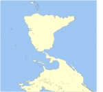
I will of course abide by whatever the group decides. I feel that using the real world map moves away from the realm of Fantasy and into Alternate History. Now, I love AH as much as the next guy but I'm not sure thats the feeling we want to convey. BUT, if we still want to use earth there are ways to make it less obvious. For example, turn the map upside down and backwards. Also, cut apart continents and move them around a bit.

10 minutes in Inkscape
 

Attachments

  • 1160.png
    1160.png
    22.8 KB · Views: 83

Remove ads

Top