Libramarian
Adventurer
I've been looking for good maps at the 1 mile-per-hex "province" scale, but they're difficult to find.
Mike Schley's maps are nice but too simplistic to take advantage of the smaller scale. The contour maps in old TSR modules had the right idea but they're ugly and difficult to use. Amateur maps are usually terrible all-around.
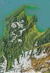
Luckily I stumbled upon www.maphill.com, which makes pretty topographic maps of real-world regions. Just search for a county/district/prefecture from somewhere around the world and you have a province-scale map.
Here are some of my favourites:
http://www.maphill.com/switzerland/tessin/ticino/maps/satellite-map/
http://www.maphill.com/norway/hedmark/maps/satellite-map/
http://www.maphill.com/united-kingdom/wales/wales/powys/maps/satellite-map/
http://www.maphill.com/new-zealand/nelson/tasman/maps/satellite-map/
http://www.maphill.com/japan/kyushu/kumamoto/maps/satellite-map/
http://www.maphill.com/bhutan/wangdiphodrang/maps/satellite-map/
http://www.maphill.com/greece/ipiros/ioannina/3d-maps/satellite-map/
The labels would have to be edited...unless you want to use them as-is. Since my players and I are unfamiliar with the towns/villages of New Zealand, I actually wouldn't mind using them for a fantasy map. (If you're from New Zealand I imagine you could do the same with a Canadian map.)
Mike Schley's maps are nice but too simplistic to take advantage of the smaller scale. The contour maps in old TSR modules had the right idea but they're ugly and difficult to use. Amateur maps are usually terrible all-around.
Luckily I stumbled upon www.maphill.com, which makes pretty topographic maps of real-world regions. Just search for a county/district/prefecture from somewhere around the world and you have a province-scale map.
Here are some of my favourites:
http://www.maphill.com/switzerland/tessin/ticino/maps/satellite-map/
http://www.maphill.com/norway/hedmark/maps/satellite-map/
http://www.maphill.com/united-kingdom/wales/wales/powys/maps/satellite-map/
http://www.maphill.com/new-zealand/nelson/tasman/maps/satellite-map/
http://www.maphill.com/japan/kyushu/kumamoto/maps/satellite-map/
http://www.maphill.com/bhutan/wangdiphodrang/maps/satellite-map/
http://www.maphill.com/greece/ipiros/ioannina/3d-maps/satellite-map/
The labels would have to be edited...unless you want to use them as-is. Since my players and I are unfamiliar with the towns/villages of New Zealand, I actually wouldn't mind using them for a fantasy map. (If you're from New Zealand I imagine you could do the same with a Canadian map.)
")