
jdavis
First Post
Conaill said:And one more reference: Mor's End is about 7000 feet end-to-end, or about 1.3 miles. The width of the swamp on those maps is about the same. Do we really want to have a swamp you can walk across in just over half an hour?
Mor's End is quite small. If we really want the swamp to be a significant threat/obstacle, it'll have to be quite a big larger than in the maps above.
You're right that 50 miles is probably too much. And 1.3 miles is presumably too small. Do we want to make it 8 hours by an average horse? That would be 24 miles. Still too wide to cross by caravan in a single day. Or do we want to make it a "forced march" by caravan, say 12 hours? That would be 18 miles across.
Either way, that ferry crossing to the southern trade route will need to be redrawn as well. I don't think we want to make the big island *that* long.
Just as a reminder, here's the distances per 8-hour day for the swamp:
Walk, trackless: 12 miles
Walk, on causeway: 18 miles
Caravan: 12 miles
Horse: 24 miles
Fast horse: 36 miles
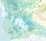
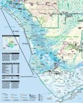
If you go by the first map I put up the swamp runs all the way down the southern coast of the lake, I just put up the closer one to show where the caravan crossed to the big island, it was a older map. My point is that you are never crossing the swamp you are skirting the dge of it along the coast, you really don't ever go into the swamp you just run across one small corner of it. I wasn't trying to show scale with the second map just how the route ran over the island.
There really needs to be a final version of the area map in scale with the caravan routes and the swamp. I'm assuming the swamp is hundreds of miles deep and at least 50 miles across, 100 would be perferable, but that doesn't have much to do with the caravan route it just barely goes through the corner of it.
")