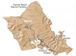
Alsih2o showed me how to do a google image search (when I asked about finding maps on the internet). You can go to google, and click on the images tab, and then type in a criteria. I found this map by typing in "island map".
As you can see, I filled in the valley with various shades of green, and also included a lake in the center, and several rivers. I also slightly increased the size of the small island in the SE corner.
And then finally, I added in some gridlines to produce the finished product.
Another map of Oahu, Hawaii that I had showed a scale of 10 miles being equal to almost half the distance across the entire island. So, by placing a grid on it, I effectively changed the scale from a tiny little thing, to an entire continent. The "hills" of Oahu suddenly became vast expanses of mountains as well.
What I was planning on doing was to do a large zoomed-in picture of each square on the grid (at least the relevant ones) and place numbers so that I knew where the interesting locations where.
This is actually a lost continent (think Isle of Dread, 'cept larger) so there aren't any major cities or trade routes. There are abandoned ruins, and dungeon locations, however.
What I was planning on doing was to do a large zoomed-in picture of each square on the grid (at least the relevant ones) and place numbers so that I knew where the interesting locations where.