I've been browsing some more medieval maps, in my ongoing campaign against "water walls". ")
Here's some links to individual maps that I think are relevant to this discussion. I won't post the whole map here, because that is bound to get a little big. All of these are from the two resources I've mentioned before:
Historic Cities: Maps & Documents (The 1550 Cosmographiae Universalis by Munster seem to be the earliest high-quality aerial views)
Dutch City maps from Blaeu's Toonneel der Steden
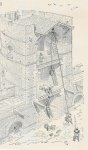
I've seen lots of covered bridges, lots of reinforced bridges inside the city, lots of walls along the river banks, but so far no actual water wall of the scale Knightfall is suggesting for Mor's End.
1) Map of Florence, 1550: The squiggly line across the river in the foreground may be a chain, or may just indicate the city border, but it is definitely *not* a fixed reinforcements. Note the towers on either side of the river, and walls along the river banks.
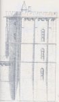
2) Map of Basel, 1550: Note the tower jutting out into the river lower right; walls along part of the river banks; city walls on opposite sides of the iver don't need to line up.
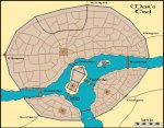
3) Paris, 1550 and Paris, 1572: Good model for Mor's End, with the river crossing across the island (although not entirely to scale, I assume). Towers and some walls along the river banks.
4) Dockum, 1652: At the top of the map, there is one of those bridges that open up in the middle. Not reinforced, and a much smaller span that what we are facing. At the bottom there does seem to be a small water gate, but clearly too small to let ships pass through, that's why they need the tilt-bridge in the North. (Sorry for the scale, but the details are kinda hard to make out on the smaller version...)
5) Maastricht, 1652: Some defensive towers and walls along the banks.
6) Middelburg, 1652: Note the walls sticking out into the river at the entrance to the city.
7) Zwolle, 1652: Earthenworks overlooking the river and some bridges, but no actual water walls.
Do I need to go on? I could probably dig up another ten or so...
How about this for a compromise:
- We keep the water wall on the Western branch. It's the shortest span, and the ships mainly come through the Southern branch anyway. Even better: remove the outher water wall, but keep the reinforced Wallbridge and the walls from the ringwall to the bridge. That's a veritable deathtrap if invaders get stuck in that little piece of water with walls on three sides...
- We add some towers jutting out into the river at the Southern and Eastern river branch to form a bottleneck for anyone trying to invade the city from that direction.
- We post some lookout towers lakewards of the southern branch. We should easily be able to get some advance warning from those.
- We reinforce the river banks with walls on the southern end of Port Jollita and the docks.
- We span a chain that can be raised at night across the southern branch
All of those have real-world precedents, and combined they should provide significantly more security than putting a huge arch across the river...
Opinions?
Here's some links to individual maps that I think are relevant to this discussion. I won't post the whole map here, because that is bound to get a little big. All of these are from the two resources I've mentioned before:
Historic Cities: Maps & Documents (The 1550 Cosmographiae Universalis by Munster seem to be the earliest high-quality aerial views)
Dutch City maps from Blaeu's Toonneel der Steden
I've seen lots of covered bridges, lots of reinforced bridges inside the city, lots of walls along the river banks, but so far no actual water wall of the scale Knightfall is suggesting for Mor's End.
1) Map of Florence, 1550: The squiggly line across the river in the foreground may be a chain, or may just indicate the city border, but it is definitely *not* a fixed reinforcements. Note the towers on either side of the river, and walls along the river banks.
2) Map of Basel, 1550: Note the tower jutting out into the river lower right; walls along part of the river banks; city walls on opposite sides of the iver don't need to line up.
3) Paris, 1550 and Paris, 1572: Good model for Mor's End, with the river crossing across the island (although not entirely to scale, I assume). Towers and some walls along the river banks.
4) Dockum, 1652: At the top of the map, there is one of those bridges that open up in the middle. Not reinforced, and a much smaller span that what we are facing. At the bottom there does seem to be a small water gate, but clearly too small to let ships pass through, that's why they need the tilt-bridge in the North. (Sorry for the scale, but the details are kinda hard to make out on the smaller version...)
5) Maastricht, 1652: Some defensive towers and walls along the banks.
6) Middelburg, 1652: Note the walls sticking out into the river at the entrance to the city.
7) Zwolle, 1652: Earthenworks overlooking the river and some bridges, but no actual water walls.
Do I need to go on? I could probably dig up another ten or so...
How about this for a compromise:
- We keep the water wall on the Western branch. It's the shortest span, and the ships mainly come through the Southern branch anyway. Even better: remove the outher water wall, but keep the reinforced Wallbridge and the walls from the ringwall to the bridge. That's a veritable deathtrap if invaders get stuck in that little piece of water with walls on three sides...
- We add some towers jutting out into the river at the Southern and Eastern river branch to form a bottleneck for anyone trying to invade the city from that direction.
- We post some lookout towers lakewards of the southern branch. We should easily be able to get some advance warning from those.
- We reinforce the river banks with walls on the southern end of Port Jollita and the docks.
- We span a chain that can be raised at night across the southern branch
All of those have real-world precedents, and combined they should provide significantly more security than putting a huge arch across the river...
Opinions?
Last edited: