Here's my latest.
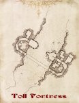
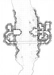
This is actually part 1 of the prior map. En route to the drow archaeological dig, the party came across an old toll fort along what used to be a major underdark trade caravan.
Originally, the building on the right was the main entrance to the 'fort' and they would have pedestrians travel up and over the fort to be inspected, whereas caravans would pass between the tower and fort.
The tower on the left is a full 20 feet higher than the fort on the right (the floor of the tower is 30 feet above the cave floor). It has no access points except via the undercave passage between the fortress and the tower.
In my campaign, the Cerebrelith had been using this as his base of operations between hunts. When the players arrive it is abandoned but there are multiple skull-less bodies hanging from the archway of the tower on the left as well as some in other locations throughout the structure.
- - -
This was mapped using a blue pen instead of my typical mechanical pencil, on standard (although water-damaged) 4-quad graph paper. This meant I couldn't go back and change any mistakes, but it also provided for cleaner detail work in many places (especially along cave walls). After scanning, I desaturated it and increased the contrast to make it look black. The parchment was the one I designed for a book ENP released to support the ENnies two years ago - the base is a scan of tea-soaked paper, with some digital enhancements.


")
")