

Finster
First Post
This is mt first thread, so please excuse me if this gets messed up.
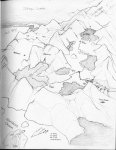
I have sketched a map for my homebrew setting of a mountainous region. The map is hand drawn (I don't have access to terrain generation software) in pencil and scanned from my sketch book.
My question is this:
Do you think that a map like this can be used in playing a game, or do you think that it is neccessary to have a scaled-out topographical (view from above) map? Would something like this make a good hand-out for my players?
I would like to draw my entire setting out like this, region by region, but I don't want to waste a lot of time on it, if it will just get thrown in a folder and never used.
")