You are using an out of date browser. It may not display this or other websites correctly.
You should upgrade or use an alternative browser.
You should upgrade or use an alternative browser.
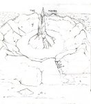
Is a map like this useful?
- Thread starter Finster
- Start date
Land Outcast
Explorer
Well... as a player (or DM) I wouldn't see it as a map.
Actually I'd probably make a copy and hang it up on my working table just for inspiration
awesome? yes, that word fits: awesome.
Not very eloquent today, I beg your pardon
Actually I'd probably make a copy and hang it up on my working table just for inspiration
awesome? yes, that word fits: awesome.
Not very eloquent today, I beg your pardon
BigFreekinGoblinoid
First Post
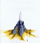
Dude, great map ( The one with the spire is cool too ).
I know my players would immediately dub the "Drumereton" (sp- hard too see ) "Turkey Mountain" though...
I know my players would immediately dub the "Drumereton" (sp- hard too see ) "Turkey Mountain" though...
Exiledprince
First Post
Finster said:This is mt first thread, so please excuse me if this gets messed up.
I have sketched a map for my homebrew setting of a mountainous region. The map is hand drawn (I don't have access to terrain generation software) in pencil and scanned from my sketch book.
My question is this:
Do you think that a map like this can be used in playing a game, or do you think that it is neccessary to have a scaled-out topographical (view from above) map? Would something like this make a good hand-out for my players?
I would like to draw my entire setting out like this, region by region, but I don't want to waste a lot of time on it, if it will just get thrown in a folder and never used.
Yes it is useful. I will be using it tonight. Make more maps.
BTW could you please highlight them in black ink.They tend to print in a faded manner. Thank you.
Last edited:
Very nice maps... while I may not use them, they definitely inspire me to make maps of my own in a similar perspective.
Whether you have a scaled 2D map for yourself or DM or not is up to yourself - the PCs likely only have access to non-scaled maps.
For large amounts of flavour (particularly if you can draw in multiple styles), you could draw different maps from different perspectives - the plainsmen have a very low to the ground feel, while the griffon-riders of the eyrie's have a near overhead view.
Captain Howdy
Explorer
adwyn said:As a player I'd rather receive a map like that than any other. If you're worried about scale do a 2nd DM only map that is more basic and conventional, but do keep using tis style for the players' maps.
I agree with this. You might want to do a basic overland map with a scale for yourself, to keep track of distances and such, but that map is really nice for a player handout. That could even be photoshopped into looking like an old hand-drawn map they might find in a treasure hoard or something.
Eosin the Red
First Post
Finster said:This is a close up of the thing at the center of the second map. It is also in color!
Nice piece of work. Your maps are pretty cool.
Similar Threads
D&D General
Mapping: How Do You Do It?
- Replies
- 133
- Views
- 23K
- Replies
- 4
- Views
- 2K
Recent & Upcoming Releases
-
June 18 2026 -
October 1 2026


