psyekl said:
John Morrow: Providing something that looks that good isn't the problem. Spending the time and effort to make something look that good then finding out that very few people even wanted it, now that's the problem.
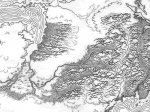
Fair enough. What I'm trying to say is that I'd want maps that I couldn't just slap together myself in a few hours. I'm looking for something that looks cool. Judging from the sample, I think you are on the right track, though color was part of the attraction for me with that WotC map. One suggestion from looking at the sample -- make sure that you leave enough room for the GM to add in his or her own labels, place names, and cities and such. A lot of your map is covered in art. In practice, that could mean either (A) more whitespace or (B) scanning in the geographic features in a mid level gray or various colors or tings and making the main land outlines black. Basically, the GM needs to be able to write over what you've drawn and have it be readable. If you use color, remember that printing large areas of dark color will kill ink cartridges. Keep the large areas of color light.
Again, electronic versions help mitigate these problem if the GM will be adding labels electronically (in Canvas, for example, I simply put a 2pt white line around black text and it creates letters with a white knock-out space around them). They can also color in their own maps.
You probably also want to clean things up a bit more after the scan (e.g., despeckle, make the background pure white, adjust the contrast, etc.). But overall, it's nice work.
psyekl said:
I don't doubt that my style will be appreciated for the most part, but appreciation and marketability are not necessarily in the same boat, which is why I want the input from the very people I'm doing this for.
Absolutely. But give me a map that I can write (either physically or electronically), adding my own place names, cities, and boundaries. You should do that excercise yourself with a copy of one of your maps. How readable are the results?
psyekl said:
I wasn't planning on including a grid or scale on overland maps unless I thought it would be absolutely necessary. Indoor maps will almost always have a scale and grid.
Great. I wasn't thinking about indoor maps. Two points out indoor maps.
First, I was impressed enough by Green Ronin's "Dungeons of Dooms: A Compendium of Fantasy Maps" to buy it. If you want to see the sort of blank interior dungeon maps that I'd pay $20 for in a book, that's the book to look at because I did, after all, buy the thing. It's not perfect but I can actually see myself using some of those maps for the underground portion of the game that I'm running.
Second, I think a fairly complete book of reasonably common and mundane buildings that appear over and over again in fantasy games could be useful -- a few inns and taverns (perhaps "small", "medium", and "large"), a few shop types (perhaps those same size categories or maybe by the class of goods tehy sell), some generic temples, generic keeps, generic towers, etc. The key is to make the designs the generic cookie-cutter designs that a GM can use over and over again (the equivalent of a "colonial", "ranch", "split-level", etc. in houses) rather than oddball architecture that can only be used once (e.g., round inns, taverns with quirky features, towers build in unusual places, temples clearly designed for a specific deity, etc.). I think I'd buy a generic book of medieval fantasy buildings, especially if you did some homework on the designs. Again, my preference is still electronic here (so I can label, modify, etc.) but I'd probably buy a book like this.
Specifically, I have some of the old Citybook series of supplements but the buildings are too specialized. Rather than an "inn", it provides a specific inn. For blank floorplans, I'd want plans that can be used over and over again. And in reality, many buildings are built to certain general patterns over and over again because they work.

")
![:]](http://www.enworld.org/forum/images/smilies/devious.png "Devious :]") ! WotC's maps are rapidly cranked-out digital collections of random rooms thrown together to provide a place to run the game. I'm going to be designing maps with logical floorplans and artistic flourishes and details rarely seen in gaming products. I didn't like the Map Folio at all, and I've yet to be impressed by WotC's map-a-week (though I haven't seen them all). Basically I'm going to put out the type of product I'd like to see, but using the advice of actual gamers to make sure it's something we'll all be able to use.
! WotC's maps are rapidly cranked-out digital collections of random rooms thrown together to provide a place to run the game. I'm going to be designing maps with logical floorplans and artistic flourishes and details rarely seen in gaming products. I didn't like the Map Folio at all, and I've yet to be impressed by WotC's map-a-week (though I haven't seen them all). Basically I'm going to put out the type of product I'd like to see, but using the advice of actual gamers to make sure it's something we'll all be able to use.