D&D 5E A Scale for my map

stroke

First Post
Hey Everybody,

I'm quite new to D&D and have played it only a couple of times so far. However, I am interested in making my own campaign at some point in the future. So I read a lot and watched a ton of videos. Now I made a map by sticking to the advices of WASD20 on youtube. The only thing that really gives me headache is the map scale. Maybe some of you could take a look at it and suggest a reasonable scale that would make sense. Since I made this scan I inserted 7 citites throughout the whole map.

Thanks in advance.
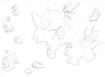
MAP_Mountains,Rivers,Lakes,Forests 001.jpg
 

log in or register to remove this ad

Tobold

Explorer
According to the rules, at a normal pace over road or flat terrain a group travels 24 miles per day. You said you have 7 cities on your map, I assume 4 or 5 of them on the main continent. Now I would think that for a "city" to have enough surrounding land to support it, cities need to be at least a week's travel apart from each other, which is 168 miles. That would make your main continent somewhere between 300 and 400 miles across, and your total map somewhere between 500 and 600 miles.
 

akr71

Hero
[MENTION=6691663]Tobold[/MENTION]'s numbers are sound. I would use those.

However, once you have put those 7 cities on the map, I would stop there. Planning an entire world from the top down is a huge effort. Pick a location where the campaign is going to start and flesh that out it detail. Preferably a small location - a town outside one of the cities or even better - a village outside of the town. From there, fill in the blanks as you need to - well, hopefully a bit in advance of when you need them, but your players will surprise you from time to time and you'll have to wing it.

It is no fun to put a bunch of effort into describing an area that the players never visit. It is fine to have some rough notes on different areas of the continent, but there is no need to go into detail for every region in advance. In fact you can off-load some of it onto the players ;) If they say there character comes from far away, ask them where and what is it like there. Take their details and absorb/mold/refine it to suit your vision.

You've got a great start to a continent and some large off-shore islands. Once the party gets to the coast, there might be areas that have smaller islands near the shore that don't show up on the map (because of scale). If they ever adventure out to some of those large islands, perhaps there is a chain of smaller ones that link the entire archipelago together?
 

stroke

First Post
Thank you very much for your helpful comments. I like the approach of Tobold and I think I am going to apply his numbers into my scale. So, its going to be 30 km per cm which makes the entire map about 1000 kms from left to right. I will also follow your advice, akr71, to let the world grow organically. I have mapped out the area east to the shown one but I'm going to concentrate on fleshing out certain locations on this map now.
 

Tobold

Explorer
[MENTION=6894199]stroke[/MENTION] : I see you prefer metric (km) to imperial (miles). I understand, and I personally also prefer the metric system. But if you are playing with the original rules (and not some of the European translations that are using the metric system) it can get complicated if you have rules that use miles and a map that uses kilometers. I'm using miles on my overland hex maps and a classic 1 square = 5 feet = 1 inch scale for my dungeon and battle maps just because I don't want to constantly convert measures.
 

I would advice not thinking scale and miles/km and instead comparing it to a globe/map.
Do you want this to be the size of England? Great Britain? Western Europe?
Especially look at the northern parts and the southern parts of your world and consider how varied in temperature you want them. Are they all close to the same? Or is the far north frozen and the far south jungle?

When you have the rough size you want, look at how that matches the real world and measure. I recommend hitting Google Maps, right clicking, and selecting "measure distance".

I'd recommend aiming small. Modern people (and North Americans in particular) are used to cars and being able to cover large distances rapidly. And large "empires" that span continents, which would have been rare.
 

cbwjm

Seb-wejem
I would advice not thinking scale and miles/km and instead comparing it to a globe/map.
Do you want this to be the size of England? Great Britain? Western Europe?
Especially look at the northern parts and the southern parts of your world and consider how varied in temperature you want them. Are they all close to the same? Or is the far north frozen and the far south jungle?

When you have the rough size you want, look at how that matches the real world and measure. I recommend hitting Google Maps, right clicking, and selecting "measure distance".

I'd recommend aiming small. Modern people (and North Americans in particular) are used to cars and being able to cover large distances rapidly. And large "empires" that span continents, which would have been rare.
This is what I did to scale one of my maps. I wanted the area to be roughly the size of Britain so I looked up the size of Britain and scaled my map to a similar size.
 

I would advice not thinking scale and miles/km and instead comparing it to a globe/map.
Do you want this to be the size of England? Great Britain? Western Europe?
Especially look at the northern parts and the southern parts of your world and consider how varied in temperature you want them. Are they all close to the same? Or is the far north frozen and the far south jungle?

When you have the rough size you want, look at how that matches the real world and measure. I recommend hitting Google Maps, right clicking, and selecting "measure distance".

I'd recommend aiming small. Modern people (and North Americans in particular) are used to cars and being able to cover large distances rapidly. And large "empires" that span continents, which would have been rare.

I'd agree with this. I made my homebrew setting roughly the size of the British mainland for the exact reason that all my players would be able to instantly understand what that meant. I suggest you do the same for your local area - pick something the size of your US state, or country, or department, or whatever - and work from there. You can helpfully also use that starting point to decide how big you want the scope of your campaign to be. If you just want to have a low-key campaign of pottering around some hills and finding ruins, then perhaps a map the size of Wales is going to be perfect, while a epic save-the-world-from-damnation quest will probably benefit from a map that will let your players travel from Wales to Jerusalem, for example.
 

stroke

First Post
Thank you all for your comments, you've helped me a lot. I applied a scale of 50 miles per inch now and I think that is going to work. Now I'm trying to flesh out specific locations that will be the starting area of a campaign.
 

Dan Chernozub

First Post
I'm running my current whole campaign for 1-2 tier PCs on an isle size of approximately Isle of Man. Going huge is tempting, but it is not strictly necessary.
 

Remove ads

Top