Yes, there are just so many nice existing places, and places that are tantalisingly undeveloped.
There sure are, Trouvere. Why don't you talk a little about some of them?
Why, don't mind if I do.
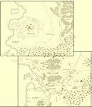
I've attached a slightly reworked version of the Orussus region and Earling maps, which overlap slightly with an offset. I've identified a few marked but unnamed locations and added a few more that we can be fairly sure of: Andren, Monemvassia, Three Rings, the Kree tribal lands, Beth Hannon, Braeholl, Havertown, Seawell, Apple Glade (this village used to be mentioned a lot!), Gemhold, Rincewood, Briarton, Triesk, Grenton, Covington, Otun, Cragger's Rest, Salt Holler.
Familiarise yourselves.
")
Also have a look at the whole world sketch map that Rae made (almost 2 years ago!). It can be found
here.
What do we know about the rest of the world?
The "missing" 250 mile wide strip east of the Earling Map presumably just contains more of the Northern Mountains and Wilding Wood, but somewhere in there probably lies the lake and village plagued by killer fish and merrows in "A Clash of Earth and Sea". I'd be interested to know what lies NE of Hendralia, since you can just see its border marker curling around.
Let's go on to the rectangle that lies immediately south of the Orussus Region Map, and call it the Riverlands Map. At the very top of this map, a river named Rheius flows into the Grellgo from the east. On the southern shore of this river is the city of
Rheim (or Riem). Over on the coast of the Great Sea, the next town down from Drolai and Raithe is
Linilo.
The eponymous Riverlands extend down the western side of the Riverlands Map. The road south crosses rivers seven times, so the area is also known as the Land of Seven Bridges. I am unsure whether there are seven different rivers, or whether one or more loop around to be crossed twice. The Riverlands are generally sub-tropical. Faint blueness on the whole world map hints that many lakes extend north-west towards the coast, south of Linilo. The small town of
Antreil lies in the SW corner of this map. The eastern half of the Riverlands Map remains as yet an unexplored blank - though I believe something can be said of it (see later).
In the rectangle immediately west of the Riverlands Map are two known locations - the city of
Severus, inhabited by gnolls, and the nation of
Ushad. Though each is described as being about 1000 miles SW of Orussus, Ushad lies perhaps 100 miles further north than Severus. Severus definitely lies in the Badlands, among rocky canyons. Ushad is a land ruled by mages who squabble constantly and duel with one another for advancement in the magocratic hierarchy. The church of Gliran is the official state religion of Ushad. As such, the country probably has a pragmatic attitude towards the use of undead (it sounds a little like Thay crossed with Karrnath to me).
The party of 'A Sojourn to Sairundan' crossed through the SW corner of the Riverlands Map into the rectangle that lies south of 'Ushad'. Heading SW across it, the land grows progressively dryer and more barren. There's not much explored in this rectangle. The tiny village of
Tillenvale, the
Haunted City once occupied by elves and dwarves,
Irid's inn on the edge of the desert. Before reaching the inn, the party could see a great range of mountains to the south-east. Once again, the Sairundan party exited this rectangle close to the SW corner, to a rectangle that contains
Sairundan and specifically
Helatia.
If you look at the whole world sketch map, you can see a major feature - a roughly 3x3 set of rectangles (each the size of our standard Orussus map, remember: 1024 x 768 miles, oddly enough) that begins at the SE corner of the Haunted City Map and contains a collection of inland seas. Large bodies of water are sufficiently scarce that they're probably quite important in Enworld.
On the sketch map, you can also follow the coastline of the main landmass in a great curve from Earling west, then north, then east, then south. Somewhere where it turns east you find the very first place that anyone could say is "on the coast north and east of Orussus". Therefore, this is where we ought to find
Osilia - "white in winter, and green in summer", 4 rectangles north of Orussus and anywhere between 0 and 2(?) east. Perhaps also the region of Damas and Ithyria, the City of Roses, though this could be on any coast with a hinterland big enough to support a great river.


")