Looks very nice for a first attempt!
Just a few comments:
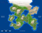
- You should probably add a legend. I assume the heavy red lines are borders, and the thin brownish lines are roads? I would make borders a dashed black line, so you can draw then on top of rivers where need be (such as the Berugh R.) I would also recommend drawing the rivers as a sharp rather than a fuzzy line. Look through some atlases for inspiration.
- Borders and roads typically don't follow smooth arcs like on your map. That would be fine for a more abstracted, "back of the envelope" map, but it clashes with the realism of the rest of your map. Again, real-world atlases can provide good examples (do try to avoid some of the more modern straight-line borders and freeways though). The Ruol-Eragar and Eragar-Prool roads seem rather strange in the way they hug the border. Major cities are typically not near a border, and major roads don't follow borders, because borders are typically very unstable areas.
- Major cities typically have a river flowing through them . Your Beladia and Lords are very noticeable exceptions, with no running water for miles around.
- Try to avoid Y-shaped road intersections. For example, unless there's a valley or other geographical feature North of Lords to force travelers to Riddyn and Carudd to travel in the same direction for a significant distance, you would not likely see such a feature (and if you did, there'd probably be a trade settlement developing there).