Hi Knightfall! Very nice maps, but I do have one major nit to pick...
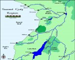
The arrangement of rivers and inland lakes seems *very* unrealistic to me. Let's look at the rivers first: A typical river watershed consists of several smaller streams joining together (typically coming from mountainous regions) into a larger river, and then flowing into the sea. Only
very rarely do you see a river split into two (typically in a delta near the river mouth), or even forming a loop. A real river will almost always carve out one of the two branches deeper than the other, and then just follow the path of least resistance.
Your rivers are almost exactly the opposite: they tend to start relatively wide, split into several smaller streams and
then flow to the sea. In fact, several of your maps would look a lot more realistic if you were to reverse the direction of flow in the rivers!
For example, on your "Kingdom of Thallin (north)" map, the branching pattern of the rivers indicates the water should be flowing from the bottom to the top left. On the "Lake Nest Region (West)" map, the "Riviere de Vie" looks like it flows left to right. On the "Duchy of Minar" map, all rivers seem to be flowing
towards the Sunus Mountains (and you even seem to have one river crossing another in the center of the map). On the "Guardian Bay Region" map all the rivers seem to be flowing bottom left to top right, etc... On the "Kingdom of Ahamudia" map for example they
do flow in the correct direction.
Loops: you have a loop of rivers on the "Eastern Shores", "Ragik Peninsula (east)", "Northwest Malecade", "Lion Mountain Peninsula (south)", "Harqual's West Coast", and probably some of the other maps.
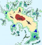
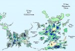
Lakes: you have an amazing multitude of very large lakes on your maps. Several of which are so close to the ocean they would probably have emptied out into it by erosion over the course of the millenia. For example, your "Harqual Continent Overview" map on this page has a large elongated lake in the top middle, almost hugging the coast over most of its length, with no exits to the ocean. You could only get a feature like that if there was a ring of mountains all along the lake borders, isolating it from the ocean. Likewise with the large lake on the island in the top left of the map.
Look at an atlas of our own world: how many actual lakes can you see on a continental map? The North American Great Lakes are
definitely an exception to the norm. If Harqual is about the same size of North America, you just placed about 10-20 Great Lakes on the same surface area!
Also, a large lake typically forms in a fairly flat landscape, exceptions notwithstanding. However, the shape of your continents seems to indicate a very rocky geography. Compare the outlines of Harqual and Janardun with those of continents on earth for example: yours almost look like partially submerged mountain ridges. And mountain lakes tend to be
much smaller...
I don't want to sound overly critical here. I have definitely enjoyed seeing your maps, and I appreciate how much time and effort must have gone into them. But the weirdness of the whole hydrology is something that just jumps out at me.
Of course, it's always possible that your world simply has a very strong God of the Rivers and Lakes. With a little magic, anything's possible.


