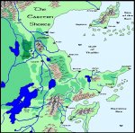
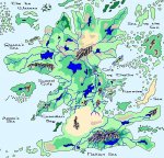
Knightfall's "CC2 Cartography" Thread (Retired: Apr 16/05)

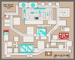
Robert Blezard's Super Dungeon - Level 1

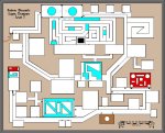
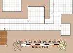
Ok, here's a little project I was working on about a two or three months ago (must really get back to it soon). This is the first level of a dungeon I'm referring to as my Super Dungeon. (Once you see the map scale in my next post, you'll see what I mean.)

Anyway, here's the overview of level 1. Note that blue is water and red is lava.

{EDIT}

Brown is boiling hot mud and black is a open air shaft down to the next level! :)

Cheers!

RPB
 

Attachments

  • sdungeon-lvl1.jpg
    sdungeon-lvl1.jpg
    143.3 KB · Views: 302
Last edited:

log in or register to remove this ad


Guardian Bay Region - Redux

Ok, redid a lot of this region including adding more terrain symbols and adding several new communities, which will either be a part of Izmer or just on the edge of it.

All of the towns that fall within the hills around Antius are under that's city's control, while those near the mountains and hills of The Fortress are more independent unto themselves, although they pay hommage to Izmer.

Note: West of this map, along the shore of Guardian Bay, is the City of Eversink based on Piratecat's excellent Defenders of Daybreak story hour. To the east of the region will be a version of the EN World City Project (Mor's End) modified slightly to fit into the background and history of my World of Kulan campaign setting. (That's region is my next planned mapping project. :) )

Cheers!

KF72

{EDIT}

I'm alos planning on incorporating Cauldron from Dungeon Magazine into the region around Izmer and Mor's End. It'll likely be closer to Mor's End though.
 

Attachments

  • guardianbay-izmer.jpg
    guardianbay-izmer.jpg
    183.2 KB · Views: 284
Last edited:

REPOST: The Eastern Shores

Ok, I had to redo my Eastern Shores Overview Map again. Somehow, when originally creating this one, I left out vital mountain and hill terrain in the northwest corner of the map.

(I don't know what I was inhaling at the time but it must have been good stuff. Just kidding... :D )

Cheers!

KF72

p.s. I've added my Guardian Bay Region map to my EN World Art & Cartography Gallery. I've also taken down the overview maps as they tend to change too much over time for them to remain consistent enough to be in a gallery.
 

Attachments

  • eastern_shores.jpg
    eastern_shores.jpg
    120.7 KB · Views: 267

Harqual Overview Redone!

Ok, I have Conaill to thank/blame for all the revision work I've been doing on this map. (Not that that's a bad thing.)

I decided to shrink the hughe northern lakes down so they aren't so dominantm, as well as redoing several river systems. i've also added more mountainous features to the map. Anywhere that there is brown terrain without mountain symbols will be for hill terrain, which I don't add to maps at this scale (redraw rate is two slow).

So Conaill, what do you think? :)

{EDIT}

This is by no means a final version.
 

Attachments

  • harqual_overview.jpg
    harqual_overview.jpg
    161.8 KB · Views: 261
Last edited:

My Version of Mor's End

Ok, I had to rework an entire region of my continent of Harqual so that I could make my own version of the EN World City Project fit into my world. This includes Mor's End, Kul Moren and Lalaton, as well as my own little additions to the region - the ruined castle known as Helguar, an evil magic tower called Nonar Kyll, and the small ruins of Farfox.

Note: This isn't anything official about Mor's End but it does show that with a little work the city can fit into any campaign setting.

The other major addition to this map is Cauldron, The Shackled City. Anyone who has been following the latest developments in Dungeon Magazine should know what this is. (For those that don't, Cauldron first appears in Dungeon Magazine # 97.) In my world, Cauldron holds sway over the town I call Ialin.

Also on this map is an eastern porton of the Kingdom of Izmer, which I've also 'homebrewed' into my campaign setting. Pretensa and Wellin fall into this region.

The Fortress is also part of the same region as Izmer is in and is home to a colony of mountain dwarves that call themselves the Du'gar.

The Verdalf Forest is home to tribes of hunter elves but tend to be isolationists for the most part.

Cheers!

Knightfall
 
Last edited:

Map moved down two posts.

Needed to change it again in order to edit out some mistakes and match my map closer to what's going on under the Plots & places forum.

The map is now posted right after the next post -- the city map of Mor's End.
 
Last edited:


Krug said:
Oooh wow nice maps Knight!

Thanks Krug. Since I do most of my mapping work using my good hand and the mouse, it doesn't hurt to do it. Thus, it gives me something to do when it hurts too much to type. BTW, I just did a initial version of Mor's End and posted it to the geography thread under plots and places.

For those that haven't checked out Mor's End yet, why not?

Here's the latest version of the map:
 

Attachments

  • mors_end.jpg
    mors_end.jpg
    91.6 KB · Views: 243

Remove ads

Top