Worlds of Design: Medieval Travel & Scale

We previously established the fundamentals of world-building; with a world’s basic rules down, it’s important to consider how you get around in that world. And travel was very different (read: slower) in a medieval setting.

We previously established the fundamentals of world-building; with a world’s basic rules down, it’s important to consider how you get around in that world. And travel was very different (read: slower) in a medieval setting.

canterbury-tales-1730722_960_720.jpg

Picture courtesy of Pixabay.

It’s Not That Far…

As explained by Rick Stump in “Modern Minds and Medieval Distances,” there’s a psychological aspect to travel that should be considered when role-playing in a medieval world. There’s an old saying that 100 years is a long time to Americans but not to Europeans, while 100 miles is not far to an American but far for a European. The time or distance doesn’t change, of course, but the perception is quite different.

Maps can also be deceiving. Nowadays in Western countries there are usually paved roads from most anywhere to anywhere. So when you look at a map you think of distance as closely related to the number of inches between two points on the map. But this varies with terrain and especially with technology.

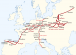
I’m in the early stages of designing a game about the American Civil War (ACW), and of course I knew that the war tended to be divided into eastern and western theaters. The reason is obvious on a certain kind of map, one that shows railroad lines or one that shows the Appalachian Mountains as a barrier, as they were in those days when the railroad lines didn’t go through the mountains. Railroads were the vital method of transportation for ACW armies.

Or look at a map of the Roman Empire. What’s not obvious is that water transportation was much quicker and much cheaper than land transportation, even with the fine Roman road network. So if you just look at the map you get a completely skewed idea of how transportation (and communication) worked.

I once found online an interactive map that showed the weeks of transportation from Rome (it's gone now, but Orbis is similar). You can easily see that it would be quicker to transport something from Rome to southern Spain than from Rome to northern Italy, especially because there are not big north-south running rivers in Italy sort of analogous to the Mississippi River in the United States. River transport was much cheaper than land.

Or is It?

The standard method of transportation in medieval times was walking. Even if you had a cart to carry goods you weren’t going to ride on that cart very much, nor would a cart with solid wooden wheels go very fast. At normal walking speed, which about 3 mph, it takes a heck of a long time to get most anywhere!

Yes, we have examples of forced marches by military units in times before mechanization that are sometimes mind-boggling, as much as 50 miles in 24 hours, though more commonly 20 miles in 24 hours. What you don’t hear about such events is that a lot of soldiers did not get to the end of the march, they dropped out for various reasons or struggled along far behind.

The U.S. Army 30 years ago would periodically send their troops on “12-mile road marches,” carrying about 80 pounds of equipment; that really wore out the guys I knew, who of course weren’t doing it every day, and did not look forward to it. I think the farthest I’ve ever walked in one day was 7 miles, without a backpack, and it sure ruined me for a while (thanks partly to flat feet).

Riding a horse would make this somewhat more comfortable but not much faster. Even when you ride a horse, for a significant part of a long journey you’re walking and leading the horse. Or you won’t end up with much of a horse.

You can see how much difference magical automobiles would make in a medieval world (provided roads are available . . .), let alone something like a magic carpet. We lose some of the sense of wonder such items would invoke in medieval inhabitants because we’re accustomed to modern technology. Even something as simple as a walkie-talkie with good range would be a great wonder in a medieval world, and very useful to military operations or dungeon and wilderness adventures. Splitting the party (which as we all know “you should never do”) would be much safer and more useful with a walkie-talkie set.

Yes, our fantasy characters are tougher than we are, and more inured to drudgery, but we should keep in mind the difference between a non-mechanized society and a modern highly mechanized society, both as players and as world builders.
 

log in or register to remove this ad

Lewis Pulsipher

Lewis Pulsipher

Dragon, White Dwarf, Fiend Folio

GameDaddy

Explorer
The Old Roads in Eastern Europe

Unknown to the Romans, but known to the Britons, Germans, Celts, and Gauls were the old Neolithic roads from the time right after the Ice age. It was these roads that allowed the German tribes to move enmasse and invade other countries, There were a number of ancient minor roads some of which I’ll mention here, but the two major ones, was the North/South road, the via Imperii or Imperial Road, and the east west road, the Via Regia, the Road of Kings.

The Via Imperii was so named, after the Imperial Romans. From Rome, the road stretched North to what is now Nurnberg, and the Romans built the road to Augsburg at least, and perhaps to Nurnburg as well. The rest of the road was built over old German trade roads. The via Imperii road began in the North at Stettin which is on the Baltic Coast, and was a collection point for Amber as well as Chert and Flint from Northern Germany which was used in the Stone Age to make tools and weapons. Anyway the road was a stone age trade path, that was expanded and grew. It was first written about in the eleventh century, but that was about the time Northern Germany first had writing on a large scale with the churches of the nascent Holy Roman Empire. It wasn’t that the roads didn’t exist before then, it was only then, that people wrote about the roads and included the roads in books, passing that knowledge on of the trade routes.

Now the Via Rex, The Road of Kings began in Moscow and Kiev, and traveled west through Germany and France and into Spain and all the way to the Atlantic Coast. It was the trade route of the Gauls and Celts, and the German tribes, as well the Rus, the Slavs, the Tatars, the Avars, and the Belarus. This road was used by the Mongols and the Huns when they invaded Western Europe . In the time of Varus, Arminius the German commander sent messengers to the east along this road and the other old roads calling for recruits to fight the Romans, and the Marcomani sent warriors as well as the Semnones, which were about 400 Km away, and while the Romans of Varus' Legions spent the summer in German Territory “dispensing justice” as legates, the Germans secretly gathered a large army and set a trap for the Romans.

All the tribal chiefs and ancient kings knew of this ancient trade route, that is why it was called the Road of Kings, The Romans never knew about it though until after the fall of the Roman empire, because they presumed the Celts, Gauls, Britons, and Germans were barbarians and uncivilized. Never occurred to the Romans that the Barbarians might have a functioning road network.
 

Attachments

  • Via_Imperii_und_Via_Regia.png
    Via_Imperii_und_Via_Regia.png
    226.4 KB · Views: 225

log in or register to remove this ad

CapnZapp

Legend
Take the above stuff with a truckload of salt.

The Roman Empire existed hundreds of years before any mention of these roads as used by the Holy Roman Empire, a completely different empire.
 

GameDaddy

Explorer
These roads existed before the Roman Republic was even founded! They were just documented in the time of the Holy Roman Empire, because until then, ....literacy wasn't a thing in Germany. Derp. There are other older roads of course that predate the Romans all over Europe. I'm going to highlight a few of these now and add some additional commentary so that everyone here knows just how full of you know what CapnZapp is. Just like the Romans who were ignorant about the pre-existing road network in Europe, CapnZapp derides what he doesn't know. Way to go there!

There was the Kulmer Stieg. This is a synonym for the transport links from the Elbe valley over the eastern part of the Eastern Ore Mountains to Bohemian Chlumec u Chabařovic (German: Kulm), hence the name which means "Kulm Trail". It is an ancient road system of partly derelict and unmetalled historic transport routes. These historic long-distance routes have been uncovered today thanks to archaeological discoveries. The routes all head south from the Elbe valley between Dresden and Pirna and cross the Eastern Ore Mountains over mountain passes on the Saxon side between Fürstenwalde in the west and Oelsen in the east. The lowest crossings are located near Mohelnice from where they continue via Habartice and the Geiersberg as well as Krasný Les and further on over the Nollendorf Pass to Chlumec. The Kulmer Steig was an especially good transport route because the road cut a passage through untamed wilderness and 30 kilometres could be covered in a day on foot. In places it overlaps with the Old Kings Way (Alter Königsweg or Via Regia) from Cologne to Kraków and Berlin to Prague and the Salt Road (Salzstraße) from Halle to Prague.

Then there is the Rennstieg. The Rennsteig is a ridge walk as well as an historical boundary path in the Thuringian Forest, Thuringian Highland and Franconian Forest in Central Germany. The long-distance trail runs for about 170 km (110 miles) from Eisenach and the Werra valley in the northwest to Blankenstein and the Selbitz river in the southeast. The Rennsteig is also the watershed between the river systems of the Weser, Elbe and Rhine. The catchment areas of all three river systems meet at the Dreistromstein ("Three Rivers Rock") near Siegmundsburg..

These Neolithic roads existed in Brittannia as well

The Harrow Way (also spelled as "Harroway") is another name for the "Old Way", an ancient trackway in the south of England, dated by archaeological finds to 600–450 BC, but probably in existence since the Stone Age. The Old Way ran from Seaton in Devon to Dover, Kent. Later the eastern part of the Harrow Way become known as the Pilgrims Way, following the canonisation of Thomas Beckett and the establishment of a shrine in Canterbury, Kent. This pilgrimage route ran from Winchester, Hampshire, via Farnham, Surrey, to Canterbury Kent. The western section of the Harrow Way ends in Farnham, the eastern in Dover.

The name may derive from herewag, a military road, or har, ancient (as in hoary) way, or heargway, the road to the shrine (perhaps Stonehenge). It is sometimes described as the 'oldest road in Britain' and is possibly associated with ancient tin trading.

There is also the Ridgeway. The Ridgeway is a ridgeway or ancient trackway described as Britain's oldest road. The section clearly identified as an ancient trackway extends from Wiltshire along the chalk ridge of the Berkshire Downs to the River Thames at the Goring Gap, part of the Icknield Way which ran, not always on the ridge, from Salisbury Plain to East Anglia. The route was adapted and extended as a National Trail, created in 1972. The Ridgeway National Trail follows the ancient Ridgeway from Overton Hill, near Avebury, to Streatley, then follows footpaths and parts of the ancient Icknield Way through the Chiltern Hills to Ivinghoe Beacon in Buckinghamshire. The National Trail is 87 miles (140 km) long.

For at least 5,000 years travellers have used the Ridgeway. The Ridgeway provided a reliable trading route to the Dorset coast and to the Wash in Norfolk. The high dry ground made travel easy and provided a measure of protection by giving traders a commanding view, warning against potential attacks. The Bronze Age saw the development of Uffington White Horse and the stone circle at Avebury. During the Iron Age, inhabitants took advantage of the high ground by building hillforts along the Ridgeway to help defend the trading route. Following the collapse of Roman authority in Western Europe, invading Saxon and Viking armies used it. In medieval times and later, the Ridgeway found use by drovers, moving their livestock from the West Country and Wales to markets in the Home Counties and London. Before the Enclosure Acts of 1750, the Ridgeway existed as an informal series of tracks across the chalk downs, chosen by travellers based on path conditions. Once enclosures started, the current path developed through the building of earth banks and the planting of hedges.

One interesting thing that the ancient neolithic roads had in common, both in England, and across Europe, is that they typically followed along a ridgeway, or a path along high ground. If you asked the ancient people what path they would choose, they would of course, answer... "The Highway" or "High Road." which referred to the ancient neolithic tracks that existed prior to the arrival of the Romans, and many of which dated back to the Stone Age. Our ancestors were both smarter, and much more sophisticated than modern people are generally aware of. There are of course many more of the ancient roads. Many of these led almost directly from one ancient henges to other ancient henges. These are just some of the better documented ones. Many modern highways are built right over them. Ditto that for Roman roads. Many modern highways are built almost directly over ancient Roman roads, A1 I'm looking at you!

Kulmer Stieg
Kulmer Steig - Wikipedia

Rennstieg
Rennsteig - Wikipedia

The Harrow Way
Harrow Way - Wikipedia

The Ridgeway
The Ridgeway - Wikipedia
 

Attachments

  • Karte_Verlauf_Rennsteig.png
    Karte_Verlauf_Rennsteig.png
    171.5 KB · Views: 212
Last edited:

I've gotta say, this discussion has helped me understand why Sigil is made out to be so relevant in the Planescape setting. When traveling at such slow speeds, any shortcut, even as awkward a one as Sigil with its often troublesome to activate portals and its government by lovecraftian beings and deranged political movements, must be very welcome.
 

Nytmare

David Jose
I'm currently running an online, exploration based hexcrawler where the bulk of the map is unknown to even me. The world is essentially Kentaro Miura's Berserk copy and pasted onto a mostly Sumerian inspired world. Characters are the first generation of people to explore outside their city walls after the Great Old Ones came back and effectively wiped civilization clean off the face of the Earth.

The game is mildly homebrewed Torchbearer with a third party travel minigame tacked on to it. I started by just sketching out what wide swath terrain pieces I wanted where. Deserts to the west, mountains to the east, big ol rivers flowing straight up through the middle of the map. Beyond that though, the rest of the map is generated through exploration and play. Normally my games are reaaaaally heavy on art and props, but I decided I wanted to do something different for our pandemic escape hatch and landed on a game that would be, at least on my end, all text and creative writing.

The game (and mini game) however are heavily based on abstractions of intense accounting. You're keeping insane track of rations and torches and equipment; but it's all abstraction to the point that these aren't the exact number of rations and torches and equipment that you're tracking, these are only the important ones that are tied to story beats.

In amidst that, I don't ever provide an actual picture map for the players. A big part of the game involves THEM mapping things though, but even then, that map the game has them make is just a list of places that they know about, and a checkbox to denote whether or not they've been "drawn" correctly on their map. Once they have enough of that information, they can take it and start sketching out a best guess as to what the actual map that I have might look like, but they're doing all of that with only the abstractions the game provides. How many "important" rations they went through, knowing how many "suitably dramatic" times they had to stop and camp.

Overland travel that flirts with being a rigid concrete system and doesn't involve having the players stare at a satellite image is refreshing. Here there be dragons.
 

I get that the using horses has the drawback that horses need to rest too and therefore doesn't save much time, but a thought recently occurred to me:

What would be the plausibility of incorporating a big horse trailer/miniature stable on wheels into the back of a large carriage? That way horses could be rotated out. Does anybody have any thoughts on whether or not this would be doable? (I suspect that the answer likely comes down to either diminishing returns due to each team having to haul the weight of the other team and/or to the fact that wagon wheels are terrible and might not stand the weight. Does anyone have any data on this?)
 

Lanefan

Victoria Rules
I get that the using horses has the drawback that horses need to rest too and therefore doesn't save much time, but a thought recently occurred to me:

What would be the plausibility of incorporating a big horse trailer/miniature stable on wheels into the back of a large carriage? That way horses could be rotated out. Does anybody have any thoughts on whether or not this would be doable? (I suspect that the answer likely comes down to either diminishing returns due to each team having to haul the weight of the other team and/or to the fact that wagon wheels are terrible and might not stand the weight. Does anyone have any data on this?)
First question is this: assuming typical medieval road conditions, how much useful rest are those horses really going to get while being jolted around in a wagon?

That said, if the roads in one's setting are paved smooth and have no patches of mud then this idea might hold some water.
 

Whizbang Dustyboots

Gnometown Hero
I think the biggest proof that this doesn't work is that none of the horse-powered civilizations did it. It seems unlikely that no one else tried and considered it. If it had worked, it would have been insanely useful for Alexander and the Romans, for instance, with their far-flung empires.
 

Nobby-W

Far more clumsy and random than a blaster
I like to go on hiking trips here in Europe, moving from town to town every day. Not only does it feel great when you crest a hill mid-afternoon and see your destination (in my more fanciful moments it makes me feel like I'm on an epic adventure across Middle Earth or something), it also gives you a very good sense of distance. For instance, if you walk the most common version of the Camino de Santiago, from the Pyrenees, across northern Spain to Santiago de Compostella, it generally takes a month to complete the 800 km.
Hiking in Europe is quite a different experience from hiking in (say) New Zealand. If you go on a hike in much of Europe you're mostly walking between settled areas. A lot of Western Europe doesn't have much in the way of tracts of wilderness big enough to take more than a day to cross - at least outside of the arctic regions. NZ is more sparsely populated and there are plenty of walking trails that have nothing but DOC huts along them.

In Europe a day's walking is often completed with a pint or two at the pub in the village you've just arrived at. It's a remarkably civilised way to spend a day.
 

Fenris-77

Small God of the Dozens
Supporter
The wagons you'd need would be impractically large and heavy, and completely useless without a road, and quite possibly completely useless with one. Never mind the host of other impracticalities. What we really need is a small wagon that carries some little pocket dimensions, with each dimension holding maybe 50 or 100 horses and riders. The clown car image of a whole Ala of cavalry riding out of one little wagon back door is pretty delicious.
 

Remove ads

Remove ads

Top