Are you familiar with the scale of the Blackmoor region maps from the DA series?
It’s 350 miles or so from Blackmoor to Archlis on the opposite side of the peninsula.
I only pay attention to the stuff by Arneson himself. On his map, Blackmoor and Bramwald are roughly 100 miles apart. On the Greyhawk 2024 map, they are roughly 50 miles apart. Each "town" is less than one mile across. There is plenty of room.
Any discrepancies between any maps can be explained by all maps being premodern, merely guesstimates compiling disparate information from sources of various quality. A distortion of distance simply means the map wasnt made by a local.
What I care most about is the hinterland around Blackmoor itself. Everything else can be there or not.
[Edit]:
@AdmundfortGeographer
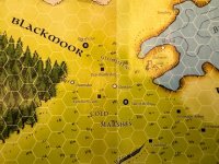
Here, I found this map online, based on the map by Arneson, and look at the scale. According to this map (by Clayton Bunce for Zeitgeist), Blackmoor and Bramwald actually are roughly 50 miles apart. So the scale of the Greyhawk 2024 map holds true. Good enough anyway. In any case, the various publications of the Arneson map have had different scales of distances, so just pick the scale that best matches the Greyhawk 2024 map.
And for comparison:
The main difference between the two maps is, the area by Arneson of the Iron Hills and Black Hills are underwater, and other parts of the "Sinking Lands" have sunk. Stuff like this can be explained, but doesnt even need to be. It is possible to use the Greyhawk 2024 map as-is, for a satisfying version of the Arneson map.