Urbis Cartography

Jürgen Hubert

First Post
I'm currently in the process of redoing my map for Urbis. The old one was functional, but not very attractive, and I'm currently trying to change that. Since I'm still new to cartography and still trying to figure out what works and what doesn't, feedback is highly welcome.

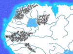
So far, I've got some basic topography - the oceans, mountains, and major rivers. Next I'm planning to add vegetation and other terrain cover - but if you have some suggestions for improving what's already there, I am all ears!
 

Attachments

  • Draft1JPG.jpg
    Draft1JPG.jpg
    237.4 KB · Views: 141
Last edited:

log in or register to remove this ad


Ilium said:
Jürgen, did you use Inkscape for this? Looking good.

I used Inkscape for the basic outlines, and then GIMP for lots and lots of filtering effects.

Since I don't draw anything with GIMP, I can easily recreate the effects - handy if I want to redo parts of the map.


Frukathka said:
I can't view it, access is denied from the computer I am using. I'd love to see it though.

Look at it here - I've uploaded it to my website.

I've also now added the locations of all the cities and other places to the map...


Jürgen Hubert said:
Look at it here - I've uploaded it to my website.

I've also now added the locations of all the cities and other places to the map...

I agree with Fru. That's very neat. Keep up the good work J.H.
 

I was wondering if there might be an interest in a workshop of sorts in a seperate thread where I tell the methods I used to create this map - and where people can try out their own filtering methods and discuss them here...
 

Is there an option to make the ridges of the mountains run out more smoothly? I think that the current solution shows too much contrast, making the mountains look spindly.
 

Remove ads

Top