I draw the occasional D&D map

Dyson Logos

Adventurer
Over the 9 years that I've been drawing maps, I've posted the occasional thread and map to these forums. With all the hoopla going on over Patreon right now (which I use extensively), I figured I could start posting highlights and updates of my work again.

I draw my maps using technical felt-tipped pens on a variety of paper. Lately I've moved almost entirely over to using 32lb white laser printer paper for my work (Hammermill's "Laser Print" paper with the butterfly on the package). The resulting maps are scanned, reduced to pure B&W, sometimes cleaned up a bit in Photoshop (to get rid of minor mistakes and debris on the page), and released at 1200 dpi on my blog ( rpgcharacters.wordpress.com )

The end result is stuff like this:

The Banshee's Tower:
View attachment banshees-tower-patreon-web.png

Fury of the Emerald Hawk
View attachment fury-of-the-emerald-hawk-patreon-web.png

Home of the Master (redrawn from module I1 - Dwellers of the Forbidden City)
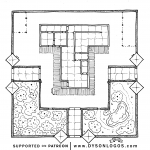
home-of-the-master-patreon-web.png

Stariphos Bay
Stariphos-Bay-Screens-Patreon.png

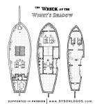
Wreck of the Wight's Shadow
wreck-of-the-wights-shadow-web.png
 
Last edited:

log in or register to remove this ad


Dyson Logos

Adventurer
My project this week is to expand on the maps provided with the classic AD&D D1 adventure. It included a sample tertiary, secondary and primary passage environment map for running encounters in. My goal is to bring each up to five samples instead of one.

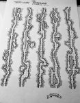
The first set of five tertiary passages is drawn as of this evening, just needs to be scanned.

D1-Tertiary-Passages-Set-1.jpg
 

Thomas Bowman

First Post
How come you draw on paper and then scan it in? I draw directly onto a jpeg file using my Paint program, I can edit easily enough and copy and paste as much as I want. For instance, I don't have to draw every single 5-foot square or 10-foot square that is on your map. If I make a mistake on paper, I can try to erase it, but I can never erase the lines I made completely, with a jpeg I can!
 

Dyson Logos

Adventurer
Because that's how I draw. I like using pens, I like the tactile experience of drawing, and the ability to draw anywhere I am. I like the permanence of ink. I like the physical artifact created. I like that my work has a distinct look and feel from my creative methods.

When I started drawing and posting work a lot, I was on disability and nearly homeless and the only computer I had was a $140 netbook. Working directly digitally wasn't an option whereas ink on paper was. I drew maps on whatever paper I had at hand.

And obviously it has made an impact on others. So I keep at it, and keep improving my skills.
 
Last edited:

Dyson Logos

Adventurer
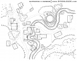
This week's first map is the thorp of Rosnar Hill that I drew up.

Rosnar-Hill-web.png

The patriarch of the cult of the White Archons retired to a tiny little thorp built up around a small bridge over an almost equally small river. He spent a small sum on fixing up the old church where he was first inducted into the order of the White Archons, and a significantly larger sum on a small tower on a hill overlooking the river and the thorp.

The town took on his name and became Rosnar Hill and is growing ever-so-slowly. The central point in town, just west of the river and attached to the bridge, is the “new bridge inn” – a quiet and rustic establishment that serves decent lamb, fair beer, and an excellent imported red wine from the vinyards of Angel’s Dell.


Thanks to my amazing supporters on Patreon, this map can be downloaded at 1200 dpi for personal and/or commercial use from the blog at https://rpgcharacters.wordpress.com/2017/12/12/rosnar-hill/


grimfish

First Post
These are fantastic as always. I frequently rip off your style when I draw my own dungeons or just doodling at work. Never with the same level of skill or imagination. I love how they are completely functional and let the game unfold without being cluttered and messy. You could prep them for the Roll20 market place or whatever fantasy grounds has and try and make some $! Love your work!


Sent from my iPhone using Tapatalk


Cripes

Villager
Have run across your maps several times before, and always been amazed by the quality and imagination. Where do you usually start? With a doodle, some random lines? Or do you usually have most of it mapped out in your head before you put the pen to the paper?
 

Dyson Logos

Adventurer
Gorgeous! I love your work!

Thank you, good sir and mayor / sheriff 'round these parts. Meriff. Mayor and Sheriff. It sounds better in my head.

Have run across your maps several times before, and always been amazed by the quality and imagination. Where do you usually start? With a doodle, some random lines? Or do you usually have most of it mapped out in your head before you put the pen to the paper?

Depends on the map. But generally it starts with one room, one hall, one set of stairs, etc, and grows on its own from there.
 

Cripes

Villager
Depends on the map. But generally it starts with one room, one hall, one set of stairs, etc, and grows on its own from there.

Ah, I really dig that variant of the creative process myself.. Just start somewhere (be it with a map, ideas for a planet, a town full of intrigue, or what have you), get going, and see where you end up. Somehow it often just starts growing on its own, developing a life and direction that you had no idea even existed. Love that.
 

Another fan here, I've copies on my bookshelves of your 2014, 15 & 16 Cartographic reviews and Dyson Delves 1&2, bought through Lulu. Hoping you might in the future publish some of your mega-dungeon compilations in the same fashion??


Dyson Logos

Adventurer
Another fan here, I've copies on my bookshelves of your 2014, 15 & 16 Cartographic reviews and Dyson Delves 1&2, bought through Lulu. Hoping you might in the future publish some of your mega-dungeon compilations in the same fashion??

I WANT to, but I don't feel that just releasing the maps in a book is sufficient, and I never find myself with enough time to really fill them up properly to the point where I'll be happy releasing them.

Love your maps. Printed out they are fabulous!View attachment 92085

Thanks!

It was definitely quite cool to be commissioned to draw a map for an official D&D product release!


Dyson Logos

Adventurer
Thunderhead-web.png

Not all towns and cities are built along rivers, trade roads, and bays… Some boast the most spectacular scenery they can find, and in Thunderhead’s case, if the scenery isn’t good enough, the whole city travels to somewhere with even better views.

Thunderhead is built on magically resistant and strong “cloudstuff”. Once the domain of cloud giants and their kin, the city is now mostly populated by humans with a smaller population of avariels along with a number of aarakocra clans that nest beneath the city in the cloudstuff itself.

Chancellor Zamhatos, a potent sphinx storm sorcerer, doesn’t so much rule the city as maintain peace through threat of power and a network of favours and information that flows out from him to the major families in the cloud. A number of churches to most of the sky gods and stormy powers can be found in Thunderhead, and the city is considered a plum assignment by most associated clergies.

The 1200 dpi version of the map can be downloaded for free thanks to my Patreon supporters at https://rpgcharacters.wordpress.com/2017/12/19/thunderhead-the-cloud-city/


Dyson Logos

Adventurer
Vigilance-Trail-web.png

Here is a somewhat rough and quick map of the Vigilance Trail as it comes down from Raven’s Pass in the Eastern Diamond Range. Not many use Raven’s Pass anymore – the major towns on each side of the pass have mostly died out and most trade now runs south of here to take advantage of routes through Yoon-Suin and the City of Copper Bowls.

Vigilance Trail still sees a few travelers every month – rarely even enough for banditry to be successful along the route. That said, someone has been burning down the abandoned structures in the area. The old inn at the base of the pass is now nothing but ashes and bits of cracked rock walls, and even Overlook Tower south of the inn structures has been burned out and is slowly collapsing with no wooden supports remaining.

The blame goes back and forth between extremist druids or other creatures in the woods, or goblins or other humanoids crawling out by Helm’s Pond at the base of the small waterfall. All that’s left in the immediate region that one would call “civilized” is the Brownside Farm by Raven’s Lake, and the small tower of the retired Magus of Orange.

There are of course several other points of interest near the Vigilance Trail.

A single menhir stands along the road between the Orange tower and the Brownside farm. The menhir is a grey stone, typical of the area, and is very worn down with very little of the old text cut into it remaining – it also detects as magical but no one has figured out exactly what the magic is.

Helm’s Pond has the obvious cave at the base of the waterfall, where rumours are that hostile humanoids are crawling up from the deeps. The reality is that this cave does indeed descend deep into the stony depths, but no humanoids make their homes here because of the much darker evil that twists the depths.

Southwest of the menhir and town is a small cave in the hills – an actual home to a small clan of goblins who try to keep to themselves and are hiding from the evil in the Helm’s Cave pond as well as the locals.

You can download the 1200dpi version of the Vigilance Trail map from the blog post at https://rpgcharacters.wordpress.com/2017/12/22/vigilance-trail/


An Advertisement

Advertisement4

Top