Worlds of Design: Medieval Travel & Scale

We previously established the fundamentals of world-building; with a world’s basic rules down, it’s important to consider how you get around in that world. And travel was very different (read: slower) in a medieval setting.

canterbury-tales-1730722_960_720.jpg

Picture courtesy of Pixabay.

It’s Not That Far…

As explained by Rick Stump in “Modern Minds and Medieval Distances,” there’s a psychological aspect to travel that should be considered when role-playing in a medieval world. There’s an old saying that 100 years is a long time to Americans but not to Europeans, while 100 miles is not far to an American but far for a European. The time or distance doesn’t change, of course, but the perception is quite different.

Maps can also be deceiving. Nowadays in Western countries there are usually paved roads from most anywhere to anywhere. So when you look at a map you think of distance as closely related to the number of inches between two points on the map. But this varies with terrain and especially with technology.

I’m in the early stages of designing a game about the American Civil War (ACW), and of course I knew that the war tended to be divided into eastern and western theaters. The reason is obvious on a certain kind of map, one that shows railroad lines or one that shows the Appalachian Mountains as a barrier, as they were in those days when the railroad lines didn’t go through the mountains. Railroads were the vital method of transportation for ACW armies.

Or look at a map of the Roman Empire. What’s not obvious is that water transportation was much quicker and much cheaper than land transportation, even with the fine Roman road network. So if you just look at the map you get a completely skewed idea of how transportation (and communication) worked.

I once found online an interactive map that showed the weeks of transportation from Rome (it's gone now, but Orbis is similar). You can easily see that it would be quicker to transport something from Rome to southern Spain than from Rome to northern Italy, especially because there are not big north-south running rivers in Italy sort of analogous to the Mississippi River in the United States. River transport was much cheaper than land.

Or is It?

The standard method of transportation in medieval times was walking. Even if you had a cart to carry goods you weren’t going to ride on that cart very much, nor would a cart with solid wooden wheels go very fast. At normal walking speed, which about 3 mph, it takes a heck of a long time to get most anywhere!

Yes, we have examples of forced marches by military units in times before mechanization that are sometimes mind-boggling, as much as 50 miles in 24 hours, though more commonly 20 miles in 24 hours. What you don’t hear about such events is that a lot of soldiers did not get to the end of the march, they dropped out for various reasons or struggled along far behind.

The U.S. Army 30 years ago would periodically send their troops on “12-mile road marches,” carrying about 80 pounds of equipment; that really wore out the guys I knew, who of course weren’t doing it every day, and did not look forward to it. I think the farthest I’ve ever walked in one day was 7 miles, without a backpack, and it sure ruined me for a while (thanks partly to flat feet).

Riding a horse would make this somewhat more comfortable but not much faster. Even when you ride a horse, for a significant part of a long journey you’re walking and leading the horse. Or you won’t end up with much of a horse.

You can see how much difference magical automobiles would make in a medieval world (provided roads are available . . .), let alone something like a magic carpet. We lose some of the sense of wonder such items would invoke in medieval inhabitants because we’re accustomed to modern technology. Even something as simple as a walkie-talkie with good range would be a great wonder in a medieval world, and very useful to military operations or dungeon and wilderness adventures. Splitting the party (which as we all know “you should never do”) would be much safer and more useful with a walkie-talkie set.

Yes, our fantasy characters are tougher than we are, and more inured to drudgery, but we should keep in mind the difference between a non-mechanized society and a modern highly mechanized society, both as players and as world builders.
 
Last edited by a moderator:

log in or register to remove this ad

Lewis Pulsipher

Lewis Pulsipher

Dragon, White Dwarf, Fiend Folio

Hussar

Legend
Fair enough. But, again, just by my quick Wikipedia look up, the world's population in 1400 was around 300 million. That's for the entire world. Think of how sparsely populated the United States is with that sort of population - there are lots of areas with where you really, really want to stop for gas and not try for the next gas station. :D

Now spread that population over the entire planet. Basically, the world looked a lot like Canada or Australia.
 

log in or register to remove this ad

Derren

Hero
Fair enough. But, again, just by my quick Wikipedia look up, the world's population in 1400 was around 300 million. That's for the entire world. Think of how sparsely populated the United States is with that sort of population - there are lots of areas with where you really, really want to stop for gas and not try for the next gas station. :D

Now spread that population over the entire planet. Basically, the world looked a lot like Canada or Australia.
The US is in my, and I admit not all that informed, opinion a good example. Around big cities (1 day or so travel) you have lots of peoples and infrastructure (in fantasy worlds meaning farms, villages, etc.), but once you get away from them and the few big roads connecting the cities its wilderness with no one around (except monsters).

Yes there are fewer people, but there were also no 3+ story houses to house them and 90% if them had to farm land to provide food. So the use of space would imo have been quite high relative to the number of people.

Edit: This is for already highly organized and developed areas for that timeframe like the coast of china, india, iraq or central europe later.
Tribal areas would be one village, a few crop fields or grazing areas around it and then wilderness for a few days till you find the next tribe/village.

And for nomads its all wilderness, although on the tame side, at least as long as you are in the area circulated by the nomads. Outside of that its pure wilderness.
 
Last edited:

Dioltach

Legend
I think both these points are very valid. Lower populations in medieval times, but also denser populations around towns and cities. Where fantasy maps go wrong, I think, is in putting too much wilderness between the centres of population. The FR adventure I mentioned above, for example, is set in a supposedly fairly populous area, but still the distances between anything are disproportionate to what people would normally travel for regular commerce.

I once hiked in Spain's Maestrazgo region. It has one of the lowest population densities in Western Europe: something like 2.5 per sqkm, if I recall correctly. We saw more eagles and mountain goats than people over the course of a week. The landscape is harsh and unforgiving: bone dry, with steep slopes and deep gorges. But still, the villages were no more than 10-15km apart.
 

Derren

Hero
I think both these points are very valid. Lower populations in medieval times, but also denser populations around towns and cities. Where fantasy maps go wrong, I think, is in putting too much wilderness between the centres of population. The FR adventure I mentioned above, for example, is set in a supposedly fairly populous area, but still the distances between anything are disproportionate to what people would normally travel for regular commerce.

I once hiked in Spain's Maestrazgo region. It has one of the lowest population densities in Western Europe: something like 2.5 per sqkm, if I recall correctly. We saw more eagles and mountain goats than people over the course of a week. The landscape is harsh and unforgiving: bone dry, with steep slopes and deep gorges. But still, the villages were no more than 10-15km apart.
Its admittedly only 2nd hand half knowledge but it depended a lot on cities. A city required a lot of food which was farmed with for todays standards very low efficency. So everything within 1 day of the city was basically farmland so that the farmers could bring the food to the market. How far you could go in a day depended on what transportation was available so along a river 1 day travel could mean some distance.

After that radius there was mostly wilderness, maybe a independent village or, more likely a fortress with town/village around it.
The more fertile and important an area was, the more cities which eventually created continous stretches of civilization.
 

Aldarc

Legend
@lewpuls, after reading this article, I would not mind seeing you try to tackle medieval medicine and healing. I have actually dated several people in medical fields who have not been particularly happy with how D&D (and many other TTRPGs) kinda trivialize and gloss over their professional expertise via magical healing and the like.
 

Derren

Hero
@lewpuls, after reading this article, I would not mind seeing you try to tackle medieval medicine and healing. I have actually dated several people in medical fields who have not been particularly happy with how D&D (and many other TTRPGs) kinda trivialize and gloss over their professional expertise via magical healing and the like.
I don't think there is a way around that. D&D and similar games are build around the idea of very quick magical healing. And when that is available mundane medicine will always be glossed over.

With the Agents of Edgewatch AP for PF2 having been released something about medieval law or government would be nice.
Other things to look at might be trade, nobility or the impact of religion. Or things like how typical towns looked like.

Or maybe something else and you take an existing article and look how the things described in there differs according to region/continent.
 

S'mon

Legend
I once hiked in Spain's Maestrazgo region. It has one of the lowest population densities in Western Europe: something like 2.5 per sqkm, if I recall correctly. We saw more eagles and mountain goats than people over the course of a week. The landscape is harsh and unforgiving: bone dry, with steep slopes and deep gorges. But still, the villages were no more than 10-15km apart.

Aye - from referring to maps of the Scottish Highlands, I use a cap of 10 miles for distance between villages in borderlands regions. More than that they are out of regular foot contact and likely to die out, so only suitable for post-apocalypse type settings.
 

Ilbranteloth

Explorer
As the article says, travel by horse would not be really faster than travel by foot, unless you can change horses frequently.

Exactly, in part because most of the time horses or other animals were used to carry stuff (or pull stuff) rather than riding.

Having animals also reduced actual travel time, because they needed to be rested, fed, and watered, and resting often meant relieving them of their burden as well. Animals were expensive, and typically only the wealthy would consider using one for riding, since we're perfectly capable of walking. And the pace would be one to not put an undue burden on those expensive animals.

(Actual) resting is something I find many (most?) games ignore in general, other than the type needed for recovering abilities. In real life, people tend not to overexert themselves unless they have to. They also really like their breaks, meals, snacks, etc. Waiting until it is light to get moving, and stopping with ample time to set up camp, collect firewood, and have a meal before it's dark as well. Long distance travel is often in large groups, and at a leisurely pace so everybody can keep up.
 

GameDaddy

Explorer
Unimproved Roads and trails in Ancient Gaul

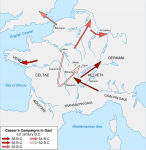
I'm going to weigh in here with some historical references campaigns along ancient roads and speak about travel times in Roman Europe. Now there were ancient roads and trails that existed in Neolithic times and were in place from about 18,000 BC or so right after the Ice sheet melted, right up until now, the modern day. Today. These ancient roads are still in use. The first ones I'm going to mention are the roads and trails that Caesar used when he invaded Gaul in 58 B.C. He traveled out of Italy up the Po river Valley and to the Rhone river valley in what is now the Burgundian Highlands. Then he traveled North along the Rhone in 58 B.C. and ended his campaign that year about 80 Km North-Northeast of Lake Geneva on the West bank of the Southern Rhine in Germania Superior where his Legions camped for the winter.

In the Spring of 57 BC he traveled west cutting France in two and attacked the Veneti Tribe north of present day Nantes along the Brittany Coast and in the modern province of Pas de la Loire on the north bank of the Loire in Western France. This was about 400 Km the Roman Army traveled on foot from their winter quarters in Cisalpine Gaul.

Caesar’s activities in the Loire Valley alarmed the Belgae to the north. Again, internal dissension among tribes led one, the Remi, to invite Caesar in against another, the Suessiones. Caesar faced 160,000 combatants with 8 legions and Gallic allies. He was outnumbered about 4:3. He defeated these as well and incorporated this new territory under his command. Next he besieged the Aduatuci, alleged descendants of the Cimbri and Teutons, 53,000 prisoners taken via siege. Then the Veneti submitted to Rome. Caesar placed Seven Legions in winter quarters along the line of the Loire River.

In the winter of 57 B.C. he split his army. The Twelfth Legion with some Cavalry went to Cisalpine Switzerland and settled into Winter quarters to protect the passes into Italy, but was attacked by the Gauls. Alba was in charge of the 12th Legion, and defeated the Gauls, but rejoined Caesars main camp shortly after that fearing a followup Gallic attack. Caesar wintered in along the Loire river in Western France again.

During winter in 56 BC, there were renegade activities of the Veneti by sea. After the conference at Luca, Caesar returned to humble the Veneti. He dispatched officers in varying directions, Labienus to watch the Belgae, P. Crassus to Aquitania. Caesar attacked the Veneti by land and sea. Again, his army was quartered for winter along the Loire, and also along the Seine in central France near present day Paris. At this point he has eight Legions, (about 90,000 soldiers, including Cavalry, plus loyal Gaul auxiliaries) who volunteered to be in the Roman Army, approximately 120,000 troops total.

The threat of more Germanic migration caused Caesar to build his famous bridge over the Rhine. Caesar conquered all of Transalpine Gaul by 55 B.C. Caesar claimed that, in the course of his conquest of Gaul, the Britons had supported the campaigns of the mainland Gauls against him, with fugitives from among the Gallic Belgae fleeing to Belgic settlements in Britain, and the Veneti of Armorica, who controlled seaborne trade to the island, calling in aid from their British allies to fight for them against Caesar in 56 BC. Strabo says that the Venetic rebellion in 56 BC had been intended to prevent Caesar from traveling to Britain and disrupting their commercial activity, suggesting that the possibility of a British expedition had already been considered by then. In August of 55 BC he took ninety-two Galleys and an unknown number of warships, and two Legions with some Cavalry, and scouted out Britannia.

The Britons opposed the landing. They were eventually driven back with catapultae and slings fired from the warships into the exposed flank of their formation and the Romans managed to land and drive them off. The Cavalry, in twelve Galleys which had launched from a different port were delayed by adverse winds, still had not arrived, so the Britons could not be pursued and finished off, and Caesar could not enjoy what he calls, in his usual self-promoting style, his "accustomed success". He withdrew before winter set in dashing the plans of the Britons to pin him into place and force his surrender during the winter.

Determined not to make the same mistakes as the previous year, in 54 B.C. Caesar gathered a larger force than on his previous expedition with five legions as opposed to two, plus two thousand cavalry, carried in ships which he designed, with experience of Veneti shipbuilding technology so as to be more suitable for a beach landing than those used in 55 BC, being broader and lower for easier beaching. This time he named Portus Itius as the departure point.

Using a divide and conquer strategy, Caesar defeated a number of British tribes, but some held out, and as winter approached Caesar was eager to return to Gaul for the winter due to growing unrest there, and an agreement was mediated by Commius, a Briton. Cassivellaunus Caesars’ foe, gave hostages, agreed to an annual tribute, and undertook not to make war against Mandubracius or the Trinovantes, Roman Allies in Briton. Caesar wrote to Cicero on 26 September, confirming the result of the campaign, with hostages but no booty taken, and that his army was about to return to Gaul. He then left, leaving not a single Roman soldier in Britain to enforce his settlement. Whether the tribute was ever paid is unknown.

The winter camps in 54 B.C. were largely in Belgica. Caesar went to Cisapline Gaul. With increasing rumors of rebellions, in 53 B.C. Caesar deposed several dangerous kings. Rebellions erupted along the Rhine (Eburones). Roman camps were overrun. There was an additional uprising of Nervii in Belgica. Caesar lost more than one legion. He recruited two more in Cisalpine Gaul, and asked Pompey for a loan of another. Caesar laid waste to Gallic territories in the north (Nervii, Treveri, Eburones, Senones, Carnutes). He installed new sets of friendly kings. Roman troops were quartered in these northern regions and in central Celtica for the winter of 53 BC. During winter, numerous Gallic chiefs conspired against him and this time organized synchronous rebellions.

In 52 BC The Averni took the lead under a young noble, Vercingetorix, whose father had been executed for aspiring to the throne. Vercingetorix took Gergovia and proclaimed himself king of the Averni. He took hostages from allied tribes and organized a large cavalry. Caesar had to march through snow-laden Alps to reach his army from his winter headquarters in Cisalpine Gaul. Vercingetorix engaged in scorched earth methods to deprive Caesar’s forces of food. Vercingetorix destroyed bridges as well to break up Roman communications. Caesar focused on sieges of rebellious towns. The Gallic desertion became widespread. Caesar’s forces were now stretched thin and over extended. Caesar assembled all forces (10 legions) into a field army to confront Vercingitorix, who at Bibracte was universally proclaimed king of the Gauls. Vercingetorix with 80,000 selected Alesia as his main base. Caesar chose to assault him there. Caesar defeated Vercingetorix in the field and encircled him in the town. Vercingetorix’ calls for help brought 250,000 Gallic warriors. Caesar’s celebrated double circumvallation. With the fall of Alesia and capture of Vercingetorix, the rebellion was crushed even though Caesars Army was outnumbered by a 4-1 margin.

All of this campaigning took place in Gaul, and along the English Coast, less than 1,000 Km from the borders of (Rome) Italy to Belgica. The Roman Legions could typically travel 50 Km a day when they were well supplied and marching during their campaign on unimproved roads and trails. Everyone who went with Caesar and survived became very wealthy from that campaign.

Caesar converted Gaul into his “hidden” powerbase: Used Gaul as a recruiting ground for troops; Also as a source of revenue, Caesar ceased to be a “debtor” and became a creditor of senators much like Crassus; took money from him; cos. Of 50 BC, L. Aemilius Paullus took a huge bribe from Caesar to refurbish the Basilica Aemilia that stood in ruins.

Events in Rome, from the tribuneship of P. Clodius, in 58 BC

The aristocracy had to build its own mob elements and Annius Milo; was recalled in 57 BC

Caesar’s growing threat in to Pompey and Crassus alike. Caesar’s 5 year grant of imperium in was due to expire in 54 BC.

The First triumvirate secretly meet at Luca in 56 BC; renewing the triumvirate: Pompey and Crassus held the consulship in 55 BC; Caesar’s external command and consulship in Gaul was renewed for 5 more years; Pompey and Crassus would each obtain extraordinary commands, Pompey in Spain and then the Mediterranean; Crassus in Syria vs. the Parthians. They prevented the elections from taking place in Rome; 55 BC began with an interregnum. Pompey and Crassus were elected consuls.

Pompey remained at and governed his provinces through legates.; adding to the division, Caesar’s daughter Julia died in childbirth in 54; Crassus died at the Battle of Carrhae in 53; Death of P. Clodius at the hands of Milo in 52; Cato agreed to let Pompey be sole consul for 52. Pompey allows all 10 tribunes to pass a law permitting Caesar to be a candidate for the consulship in absence.

Consuls of 50 BC, Aemilius Paullus; C. Claudius Marcellus, ardently anti-Caesarian. Received as his consular province Cisalpine Gaul, he made a point of scourging a citizen of Novum Comum in who was awarded Roman citizenship by Caesar.

C. Scribonius Curio, in 50 BC took a massive bribe from Caesar and conducted brilliant defense of Caesar’s position in the Senate, winning an overwhelming senatorial vote for both Caesar AND Pompey to surrender their “extraordinary commands”, disarm, and return to as private citizens. Thus demonstrating the distaste generally in Rome for civil war.

Marec Antony was in 49 BC, was driven out of Rome by Marcellus. He fled to Caesar’s camp on the border of Cisalpine Gaul, precipitating Caesar’s invasion of Rome.
 

Attachments

  • 1024px-Caesar_campaigns_gaul-en.svg.png
    1024px-Caesar_campaigns_gaul-en.svg.png
    265.6 KB · Views: 201
Last edited:

GameDaddy

Explorer
Fifty Years of Road Building.

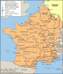
In the newly conquered territories, Augustus Caesar built roads. Attached in this post you’ll find the Roman Road map for 9 AD, right at the time that Varus lost his three legions along with his life in the battle of Teutoburg Forest in 9 AD. This was just forty years after Caesar had been assassinated in Rome.

In Varus’ time It typically took a Roman rider Just eight days to travel from Rome to Vetera which was the home of the nineteenth legion in Northern Belgium just across the Rhine from Germany. That was a 600 Km road trip, so the messengers and Roman Cavalry Officers were making about 75 Km a day. About 55 Miles a day on average. Here is how they did it…

The cursus publicus (Latin:"the public way") was the state mandated and supervised courier and transportation service of the Roman Empire, later inherited by the Eastern Roman Empire. It was a system based on obligations placed on private persons by the Roman State. They provided as contractors, "mancipes", the equipment, animals, and wagons. In the Early Empire compensation had to be paid but this had fallen into abeyance in Late Antiquity when maintenance was charged to the inhabitants along the routes. The service contained only those personnel necessary for administration and operation. These included veterinarians, wagon-wrights, and grooms. The couriers and wagon drivers did not belong to the service: whether public servants or private individuals, they used facilities requisitioned from local individuals and communities. The costs in Late Antiquity were charged to the provincials as part of the provincical tax obligations in the form of a liturgy/munus on private individual taxpayers.

The Emperor Augustus created it to transport messages, officials, and tax revenues between the provinces and Italy. The service was still fully functioning in the first half of the sixth century in the Eastern Empire, when the historian Procopius accuses Emperor Justinian of dismantling most of its sections, except for the route leading to the Persian border.

A series of forts and stations was spread out along the major road systems connecting the regions of the Roman world. The relay points or change stations (stationes) provided horses to dispatch riders and (usually) soldiers as well as vehicles for magistrates or officers of the court. The vehicles were called clabulae, but little is known of them. A diploma, or certificate, issued by the emperor himself was necessary to use the services supplied by the cursus publicus. Abuses of the system existed, for governors and minor appointees used the diplomata to give themselves and their families free transport. Forgeries and stolen diplomata were also used. Pliny the Elder and Trajan write about the necessity of those who wish to send things via the imperial post to keep up-to-date licences.

Another term, perhaps more accurate if less common, for the cursus publicus is the cursus vehicularis, particularly in the period before the reforms of Diocletian. At least one 'Praefectus Vehiculorum', Lucius Volusius Maecianus, is known; he held the office during the reign of Antoninus Pius. Presumably, he had some sort of supervisory responsibility to ensure the effective operation of the network of stations throughout the Empire and to discourage abuse of the facility by those not entitled to use it. There is evidence that inspectors oversaw the functioning of the system in the provinces, and it may be conjectured that they reported to the 'Praefectus' in Rome. However, the office does not seem to have been considered a full-time position because Maecianus was also the law tutor of the young Marcus Aurelius, apparently his main function.

Although the government supervised the functioning and maintenance of the network of change stations (with repair facilities), 'mutationes,' and 'full service change stations with lodging, 'mansiones,' the service was a department of state in the same way as, say, the modern British Royal Mail or a series of State-owned and operated hotels and repair facilities. As Altay Coskun notes in a review of Anne Kolb's work done in German, the system "simply provided an infrastructure for magistrates and messengers who traveled through the empire. It consisted of thousands of stations placed along the main roads; these had to supply fresh horses, mules, donkeys, and oxen, as well as carts, food, fodder, and accommodation." The one who was sending a missive would have to supply the courier, and the stations had to be supplied out of the resources of the local areas through which the roads passed. As seen in several rescripts and in the correspondence of Trajan and Pliny, the emperor would sometimes pay for the cost of sending an ambassador to Rome along the cursus publicus, particularly in the case of just causes.

Following the reforms of Diocletian and Constantine I, the service was divided in two sections: the fast (Latin: cursus velox) and the regular (Latin: cursus clabularis). The fast section provided horses, divided into veredi ("saddle-horses") and parhippi ("pack-horses"), and mules, and the slow section provided only oxen. The existence of the 'cursus clabularis' service shows that it was used to move heavy goods as well as to facilitate the travel of high officials and the carriage of government messages. Maintenance charged to the provincials under the supervision of the governors under the general supervision of the diocesan vicars and praetorian prefects.
 

Attachments

  • Roman-Gaulin Varus time.gif
    Roman-Gaulin Varus time.gif
    301.9 KB · Views: 154

Remove ads

Remove ads

AD6_gamerati_skyscraper

Remove ads

Recent & Upcoming Releases

Top