William Ronald
Explorer
(OOC: Edena, I thought the spat was going to come later, so I will reply later. I need to write an adequate response. Eclavdra will hate it. Also, I will have to catch up to the AFTS pact. (Rikandur, my first reaction was what were the people at WotC drinking when they signed off on it. There are EPIC Level spells that do less damage over their area of effect.) I like it, but I have to catch up to Bugbear's character. Let's say that I was inattentive to the end of the post. I was waiting for Venus to respond. However, Al'Akbar is a demigod and very far from perfect. However, I will make up for it. And give everyone an Ekbir link, although it is in French. Living Greyhawk Ekbir site and this is the main Living Greyhawk campaign site. )
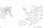
First, based on my measurements, a continent opposite the Solnor Ocean from Oerik could be fairly large. I estimated there is something like 5,200 or so miles of land or water not on the inset Oreth map on the LGG map. This is less than the distance of Africa at its widest point. So, there is room for continets roughly the size of Africa and North America. (Oerth is traditionally described as having four continents. Hepmonaland is perhaps 3,000 or more miles long and is not very wide.) The Ana Keris continent, off the southwest coast of the Oerik continent appears comparable in size to the Flanaess.
I tried downloading an old adventure that details part of Aquaria, but it did not work. I sent SV Games an e-mail. So, I will have something soon. One of the links has a timeline of Aquaria, developed by Frank Mentzner. (E. Gary Gygax did say in the past that it was canon.) I think some name changes are needed, especially for one of the rulers. Note that there should be room on an Aquaria style continent for good, neutral ane even evil factions. The modules are set about 30 years before our IR.
Here are some links I found about different versions of the Oerik continent, Oerth, and other places. Do check out the Grodog's Greyhawk pages. There is a section listing places referred to in Greyhawk books or various adventure modules. There is room for lots of concepts. (Some name changes are welcome. Several designers have retroactively apologized for some of the names on the big Oerik continent map. Plus, you can work with themes. Ishtarland could have a Babylonian or Sumerian name. Here are a few: Kalam (literally "the Land" in Sumerian, Kengir, "Land of the Gods", or Ki-Uri, "the Land of Ur.")
I think someone should claim the Olman and Touv of Hepmonaland. I can try to calculate their population and we can work with the numbers. Similarly, if Kalanyr can't have Ye'Cind, I think someone should claim him. He is a demigod with a long history on Oerth. Heck, he may be the only one on Oerth who remembers Vecna being around the first time. (Using the timeline in the History of Oerth link on page one.)
Rikandur, Iggwilv is not a demigoddess, but a very powerful arcane spellcaster. She is probably comparable in power to Mordenkainen, focusing on summoning and necromancy. I can give you some information on Tuerny the Merciless from the adventure The Return of the Eight. (Iggwilv does not get along with Graz'zt, Iuz's father, but many families have their rough spots.)
Here are some links that I found. Many concern the nature of the planet and its continents. Ironically, one answers a question I asked Serpenteye about. Apparently, not only is Oerth at the center of its solar system, the stars seem to exist within the Crystal Sphere. (Airwhale is our Greyspace expert,)
I can help out people with concepts as well as PC leaders for their factions, based on what I know of Greyhawk. Some demipowers might work well, and there are hero deities who might serve to add some Greyhawk flavor to your factionLiving Greyhawk deities, demigods, and hero deities. (I am waiting for an old Living Greyhawk Journal to arrive that details the hero deities.)
One version of the Oerik continent, using some of the Chainmail stuff. (At least the names are better than the ones on the Oerik map. This article might help you generate some ideas, such as dwarves in a mountain chain west of the Celestial Imperium or maybe a Hobgoblin Empire.): http://www.canonfire.com/htmlnew/modules.php?name=News&file=article&sid=364
Oerth Summary: http://www.canonfire.com/htmlnew/modules.php?name=News&file=article&sid=15
The Grodog's Greyhawk Adventures (Yes, this does even include a list of place names that includes Demiplanes.): http://www.greyhawkonline.com/grodog/greyhawk.html
Oerth from the Ground Up: http://www.tc.umn.edu/~monax002/Council/OJ3/go1.html
Measuring Oerth from the Ground Up: http://www.tc.umn.edu/~monax002/Council/OJ4/measure.html
Gord's Greyhawk (Place names and people from E. Gary Gygax's Gord the Rogue novels):
http://home.comcast.net/~chris.s/bakluni.html
The High History of the Flanaess (Includes a timeline for Aquaria.): http://www.tc.umn.edu/~monax002/Council/OJ1/history3.html
") If that landmass is supposed to be two continents though, the Solnor is going to have to expand tremendously and Polaria and Hyperboria will make even less sense as polar masses I think.
If that landmass is supposed to be two continents though, the Solnor is going to have to expand tremendously and Polaria and Hyperboria will make even less sense as polar masses I think.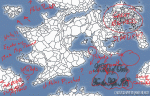
") ) for the Flanaess, and your beautiful map
) for the Flanaess, and your beautiful map